Estimation of Paddy Rice Plant Height using UAV Remote Sensing
doi: 10.14456/mijet.2021.14
Keywords:
UAV, remote sensing, plant height, estimation, paddy riceAbstract
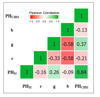
The study aims to estimation paddy rice plant height (PH) using UAV remote sensing for evaluation of the growth status of rice in fields. The study area is in Kantharawichai District, Maha Sarakham Province, Thailand. Modeling to estimate the plant height of rice from the correlation between height data from 120 sample field measurements, and reflectance data and digital elevation model (DEM) data was obtained by RGB camera-equipped UAVs, the camera has a resolution of 12 million pixels, the flight recorded an image at an altitude above the ground of 90 meters. and consider the photo data at ground sample distance (GSD) of 5 cm. Analyzed to modeling with a generalized linear model algorithm, the analysis data was divided into two parts for modeling and testing 60 and 40 percent replicas, respectively. The results show that the relationship between measured PH and estimated PH has R2 of 0.70 and RMSE of 0.13 meter. This study shows that the digital elevation model (DEM) from aerial photography with unmanned aerial vehicle, it is an important parameter in estimating the plant height of rice.
References
[2] Van Niel, Tom G., and Tim R. McVicar. Remote sensing of rice-based irrigated agriculture: a review. 2005.
[3] Mulla, D. J. (2013). Twenty five years of remote sensing in precision agriculture: Key advances and remaining knowledge gaps. Biosystems engineering, 114(4), 358-371.
[4] Wang, L., Tian, Y., Yao, X., Zhu, Y., & Cao, W. (2014). Predicting grain yield and protein content in wheat by fusing multi-sensor and multi-temporal remote-sensing images. Field Crops Research, 164, 178-188.
[5] Fernandez, M. G. S., Becraft, P. W., Yin, Y., & Lübberstedt, T. (2009). From dwarves to giants? Plant height manipulation for biomass yield. Trends in plant science, 14(8), 454-461.
[6] Boomsma, C. R., Santini, J. B., West, T. D., Brewer, J. C., McIntyre, L. M., & Vyn, T. J. (2010). Maize grain yield responses to plant height variability resulting from crop rotation and tillage system in a long-term experiment. Soil and Tillage Research, 106(2), 227-240.
[7] Chapman, S. C., Merz, T., Chan, A., Jackway, P., Hrabar, S., Dreccer, M. F., ... & Jimenez-Berni, J. (2014). Pheno-copter: a low-altitude, autonomous remote-sensing robotic helicopter for high-throughput field-based phenotyping. Agronomy, 4(2), 279-301.
[8] Sankaran, S., Khot, L. R., Espinoza, C. Z., Jarolmasjed, S., Sathuvalli, V. R., Vandemark, G. J., ... & Pavek, M. J. (2015). Low-altitude, high-resolution aerial imaging systems for row and field crop phenotyping: A review. European Journal of Agronomy, 70, 112-123.
[9] Watanabe, K., Guo, W., Arai, K., Takanashi, H., Kajiya-Kanegae, H., Kobayashi, M., ... & Iwata, H. (2017). High-throughput phenotyping of sorghum plant height using an unmanned aerial vehicle and its application to genomic prediction modeling. Frontiers in plant science, 8, 421.
[10] De Souza, C. H. W., Lamparelli, R. A. C., Rocha, J. V., & Magalhães, P. S. G. (2017). Height estimation of sugarcane using an unmanned aerial system (UAS) based on structure from motion (SfM) point clouds. International journal of remote sensing, 38(8-10), 2218-2230.
[11] Feng, A., Zhang, M., Sudduth, K. A., Vories, E. D., & Zhou, J. (2019). Cotton yield estimation from UAV-based plant height. Transactions of the ASABE, 62(2), 393-404.
[12] Wang, X., Zhang, R., Song, W., Han, L., Liu, X., Sun, X., ... & Zhao, J. (2019). Dynamic plant height QTL revealed in maize through remote sensing phenotyping using a high-throughput unmanned aerial vehicle (UAV). Scientific reports, 9(1), 1-10.
[13] Holman, F. H., Riche, A. B., Michalski, A., Castle, M., Wooster, M. J., & Hawkesford, M. J. (2016). High throughput field phenotyping of wheat plant height and growth rate in field plot trials using UAV based remote sensing. Remote Sensing, 8(12), 1031.
[14] Han, X., Thomasson, J. A., Bagnall, G. C., Pugh, N., Horne, D. W., Rooney, W. L., ... & Cope, D. A. (2018). Measurement and calibration of plant-height from fixed-wing UAV images. Sensors, 18(12), 4092.
[15] Bendig, J., Bolten, A., Bennertz, S., Broscheit, J., Eichfuss, S., & Bareth, G. (2014). Estimating biomass of barley using crop surface models (CSMs) derived from UAV-based RGB imaging. Remote sensing, 6(11), 10395-10412.
[16] Bendig, J., Yu, K., Aasen, H., Bolten, A., Bennertz, S., Broscheit, J., ... & Bareth, G. (2015). Combining UAV-based plant height from crop surface models, visible, and near infrared vegetation indices for biomass monitoring in barley. International Journal of Applied Earth Observation and Geoinformation, 39, 79-87.
[17] Kawamura, K., Asai, H., Yasuda, T., Khanthavong, P., Soisouvanh, P., & Phongchanmixay, S. (2020). Field phenotyping of plant height in an upland rice field in Laos using low-cost small unmanned aerial vehicles (UAVs). Plant Production Science, 23(4), 452-465.

Downloads
Published
How to Cite
Issue
Section
License
Copyright (c) 2021 Engineering Access

This work is licensed under a Creative Commons Attribution-NonCommercial-NoDerivatives 4.0 International License.


