Flood-Prone Map Projection and its Relationship Analysis with City Growing Map using Geographical Information System Approach: A Case Study of Flood and Urban Expansion of Jabodetabek, Indonesia
doi: 10.14456/mijet.2022.13
Keywords:
Urban expansion, Flood, Flood-prone map, Remote sensing, Geographical Information SystemAbstract
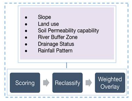
Extensive un-managed rapid city expansion extremely making flooding in many ways, which lead to huge losses and become one of a typical big-city disease, especially in developing countries. One of the great examples is in Jabodetabek (Jakarta and its surrounding area). Flood and city expansion predicted having a strong connection like diabetes and obesity. This research aims to visualize an updated Jabodetabek flood-prone map, presents which area of Jabodetabek will be flooded then compare it with the city growth map to see how these maps relate to each other. City growth detection was developed using SaTScan to see how the city significantly changes by years. Scoring using AHP, re-classifying, and weighting overlay method. ArcGIS was used to make Jabodetabek flood-prone map with rainfall pattern, land use, slope, drainage status, river buffer zone, and soil permeability capability used as the flood factors. The map-to-map comparison method was used to catch visually the differences and the similarity of the city growth map and flood-prone map. The result indicates that Jabodetabek flood is affected by many flood factors combination, high intensity of rainfall, rapid and un-managed land use and strongly supported by bad drainage condition. Flood and city growth seem correctly have a strong connection like diabetes and obesity. In one part, this city is the center of everything for Indonesia, that is why the city keeps growing and extended its development. However, the flood accelerated together with this city expansion. The trend of flood increase in several places, where the built-up area increased.
References
B. Mondal, D. N. Das and G. Dolui, "Modeling Spatial Variation of Explanatory Factors of Urban Expansion of Kolkata: a Geographically Weighted Regression Approach," Modeling Earth Systems and Environment, vol. 1, 2015.
Bappenas/Badan Penanggulangan Nasional Report, Indonesia, 2020.
N. Yuhanafia and H. Andreas, "Pertambahan Estimasi Kerugian Ekonomi Akibat Banjir Dengan Pengaruh Penurunan Tanah Di Jakarta," Jurnal Geografi GEA, vol. 17, no. 2, pp. 182-191, 2017.
Schumann, "Preface: Remote Sensing in Flood Monitoring and Management," Remote sensing journal, vol. 7, no. 12, pp. 17013-17015, 2015.
D. F. Kamasela, I. Saizen, S. K. Boontanon, "Statistical Cluster Detection of Built-up Area Changes using SaTScan," Kyoto University Master Thesis Report, 2020.
T. L. Saaty, The Analytic Hierarchy Process: Planning, Priority Setting, Resource Allocation. California, USA: McGraw-Hill, 1980.
H. Visser and T. de Nijs, "The Map Comparison Kit," Environmental Modelling & Software, vol. 21, no. 3, pp. 346-358, 2006.
CNN Indonesia. PUPR Sebut Penyebab Banjir Jakarta karena Kondisi Drainase Indonesia, February 28, available online : www.cnnindonesia.com, [Accessed: April 2021].
A. E. Pravitasari, I. Saizen, N. Tsutsumida and E. Rustiadi, "Detection of Spatial Clusters of Flood- and Landslide-Prone Areas using Local Moran Index in Jabodetabek Metropolitan Area, Indonesia" International Journal of Ecology and Environmental Sciences, vol. 40, no. 4, pp. 233-243, 2014.
D. I. Stern, "The Rise and Fall of the Environmental Kuznets Curve" World Development, vol. 32, no. 8, pp. 1419-1439, 2004.
A. Purnama, "Pemetaan Kawasan Rawan Banjir di Daerah Aliran Sungai Cisadane Menggunakan Sistem Informasi Geografis," Senior Project, IPB University, Indonesia, 2008.
Jakarta Flood Disaster Management, 2014.
Y. Budiyono, J. C. J. H. Aerts, D. Tollenaar, and P. J. Ward, “River flood risk in Jakarta under scenarios of future change, Natural Hazards and Earth System Sciences, Vol. 16, no. 3, pp. 757–774, 2016.
Finance.detik.com 2020, Potret Kepadatan Penduduk di DKI Jakarta, https://finance.detik.com/foto-bisnis/d-4904748/potret-kepadatan-penduduk-di-dki-jakarta [Accessed: April 2021].
Downloads
Published
How to Cite
Issue
Section
License

This work is licensed under a Creative Commons Attribution-NonCommercial-NoDerivatives 4.0 International License.