Catchment-Scale Flood Hazard Mapping in the Lower Areas of Lam Pao River Basin, Thailand
doi: 10.14456/mijet.2022.7
Keywords:
Flood frequency, Gumbel distribution, Flood hazard assessment, Return period, SWATAbstract
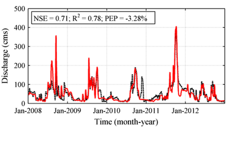
Floods have resulted in the reduction of agricultural production in Thailand. Flood hazard mapping in the lower part of Lam Pao River Basin is a challenging task because its upper part is controlled by the Lam Pao Reservoir. The present study aims at developing flood hazard maps using an integrated approach based on the SWAT hydrological model and satellite data. The SWAT model was used to transform observed daily meteorological data between 2008 and 2017 into runoff hydrographs. The results indicated that the SWAT model had capability to reproduce extreme flood hydrographs according to Nash-Sutcliffe Efficiency, R2 and percent error in peak. The simulated discharges were found to be satisfactorily fitted to the Gumbel distribution based on the Chi-square test. The flood peaks with return periods of 5, 10 and 20 years at each sub-catchment were classified into four levels of flood hazards, namely low, medium, high and very high flood hazards based on the frequency of flood occurrences acquired from the satellite data. It was found that six sub-catchments along the main river had very high degrees of flood hazard. The results of the sub-catchments S15 and S16 located downstream were verified by the satellite data. There were three flood events occurred in the two sub-catchments during the study period. Moreover, some sub-catchments of tributary streams were found to have high degrees of flood hazard. We conclude that flooding spatial information of satellite data can help to improve hydrological prediction and to prioritise flood protection areas in ungauged sites.

Downloads
Published
How to Cite
Issue
Section
License
Copyright (c) 2021 Engineering Access

This work is licensed under a Creative Commons Attribution-NonCommercial-NoDerivatives 4.0 International License.


