GIS-based Land Suitability Analysis to Support Transit-Oriented Development (TOD) Master Plan: A Case Study of the Campus Station of Thammasat University and Its Surrounding Communities
Keywords:
Geographic Information Systems (GIS), Spatial Multi-Criteria Decision Making Analysis (SMCDA), Transit-Oriented Development (TOD), Campus StationAbstract
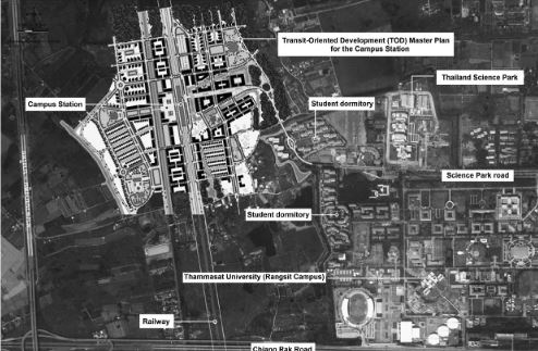
This article presents a study of land suitability analysis and Transit-Oriented Development (TOD) of a campus station of Thammasat University (Rangsit Campus). The Geographic Information Systems (GIS) and multi-criteria evaluation were used to identify the most suitable areas, in which its geospatial databases were derived from various organizations of Thailand. Eventually, the collective data was analyzed by map overlay analysis technique in an ArcView Model Builder program. In addition, integrating spatial analysis technique with the Spatial Multi-Criteria Decision Making Analysis (SMCDA) as applied to establish criteria weights and ranking them in order to analyze impacts on the transit-oriented communities and to supporting urban designer and planners with some practical approaches in decision making while planning. These analysis techniques are effective and prevalently used in various fields of studies such as geography, environmental science, landscape architecture and urban planning. Subsequently, the gathering analyzed data was applied for design guidelines of Transit-Oriented Development (TOD) Master Plan of Thammasat University and its surrounding communities. The study purposed various land uses such as commercial areas, real estate development, and necessary facilities.
Downloads
References
Atiwitawat, P., & Thongsukplang, S. (2004). Analysis of physical factors, which have influences to potential of the site in supporting settlement and city development with Potential Surface analysis (PSA): Case studies of Samut Sakhon, Nakhon Pathom, Samut Songkram,Petchaburi, Hua Hin, Pajuap Kiri Khan. Pathumthani, Thailand: Thammasat University Press.
Berlin, P., Frunzi, N., Napoleon, E., & Ormsby, T. (1999). Getting to know ArcView GIS (3rd ed.). California, USA.: ESRI Press.
Boonyopas, A. (2003). Geographic information system for landscape architecture. Bangkok, Thailand: Chulalongkorn University Press.
City Development Office. (1970). Handout for physical development and environment. Department of Provincial Administration. Bangkok: Ministry of Interior (Thailand).
Department of Public Works and Town & Country Planning. (2009). A study of standard tools for analysis of principle city planning (Final Report). Bangkok: Ministry of Interior (Thailand).
International Society on MCDM. (2017). Mission of the society. Retrieved September 18, 2017 from http://www.mcdmsociety.org.
Lathrop, W. (2001). On the horizon: Tribute (Professional Surveyor Magazine). Retrieved April 7, 2006 from http://www.profsurv.com/newpsm/archivepb.
McHarg, I. (1969). Design with nature. New York: Garden City.
Sisk, T. D. (1998). Geographic information system. Land use history of the Colorado Plateau. Retrieved April 10, 2006 from http://www.cpluhna.nau.edu/Tools/gis.htm.
Thompson, W. (1991). A natural legacy: Ian McHarg and his followers(American Planning Association). Retrieved April 8, 2006 from http://www.planning.org/25anniversary/planning/1991nov.htm.
Iamtrakul, P., & Ruangratanaamporn, I. (2016). The study on promoting hybrid canal-rail connectivity in Bangkok and its vicinity. International Journal of Building, Urban, Interior and Landscape Technology, 8, 13-26.
Malczewski, J. (1999). GIS and multi-criteria decision analysis. Ontario, Canada: University of Western Ontario Press.
Office of Transport and Traffic Policy Planning. (2009). A study of connectivity between the Sub-urban Railway stations and surrounding communities around Thammasat University. Bangkok: Ministry of Transport (Thailand).
Yang, J. L., Chiu, H. N., Tzeng, G.-H., & Yeh, R. H. (2008). Vendor selection by integrated fuzzy MCDM techniques with independent and interdependent relationships. Retrieved September 19, 2017 from http://www.sciencedirect.com/science/article/pii/S0020025508002065.
Zardari, N. H., Ahmed, K., Shirazi, S. M., & Yusop, Z. B. (2015).Weighting methods and their effects on multi-criteria decision making model outcomes in water resources management. Retrieved September 19, 2017 from http://www.springer.com/us/book/9783319125855.
Downloads
Published
How to Cite
Issue
Section
License
Copyright (c) 2017 International Journal of Building, Urban, Interior and Landscape Technology (BUILT)

This work is licensed under a Creative Commons Attribution-NonCommercial-NoDerivatives 4.0 International License.