A Collaborative Geodesign Approach for Integrating Local and Technical Knowledge in Establishing Land-Use Planning for the Border Town Comprehensive Plan
DOI:
https://doi.org/10.56261/built.v10.117038Keywords:
Planning Support System (PSS), Geodesign, Spatial indicators, Land-Use planning, Border townAbstract
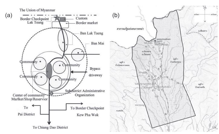
his article presents an original approach to comprehensive planning for supporting decision-making processes in the land-use planning of border town which integrates a set of frameworks and methodologies into technologies based on the use of geospatial information. The technologies embrace the domain of planning support systems, whose urban planner is based on the Geodesign framework. The purpose of this study was to develop a practical framework for Geodesign process to support the spatial planning process in practice. In this paper, a land-use suitability analysis (LUSA) method is proposed and demonstrated for the location requirements of the development and use of land. The study uses the Ban Lak Taeng Border Checkpoint Comprehensive Planning Project (a border checkpoint between Thailand and Myanmar to promoting cross-border trade and tourism, which is located in Wiang Haeng District, Chiang Mai Province, Thailand), as the research context for examining the ways that Geodesign was promoted the practical application. This Geodesign enhanced collaborative planning processes, built knowledge of natural and production systems at the urban landscape scale, and integrated consideration of feedback from multiple performance criteria into an adaptive and iterative process of land-use planning and design. The study describes the development and application of the Geodesign system used in the land-use planning process and offers important insights into how the system contributed to the collaborative stakeholder engagement, informed stakeholder decision making, and enhanced the comprehensive plan outcomes.
Downloads
References
Bank of Thailand (2016). Foreign trade through customs houses in the northern region. Retrieved December 2016 from http://www2.bot.or.th/statistics/ BOTWEBSTAT.aspx?reportID=497&language=ENG
Bentrup, G. (2001). Evaluation of a collaborative model: a case study analysis of watershed planning in the intermountain west. Environmental Management, 27(5), 739–748.
Coppola, P., Ibeas, Á., dell’Olio, L., & Cordera, R. (2013). LUTI model for the metropolitan area of Santander. J. Urban Plann. Dev., 153–165.
Dangermond, J. (2010). GeoDesign and GIS—designing our future. Proceedings of digital landscape architecture, 502–514.
ESRI Press. (2013). Geodesign: past, present, and future. Redlands, CA: ESRI Press.
Flaxman, M. (2010). Fundamentals of geodesign. Proceedings of digital landscape architecture, Anhalt University of Applied Science.
Geertman, S., & Stillwell, J. (2003). Planning support systems: an introduction. Planning Support Systems in Practice Eds S Geertman, J Stillwell (Springer, Berlin), 3–23.
Goodchild, M. F. (2010). Towards geodesign: repurposing cartography and GIS?. Cartographic Perspectives, 3(66), 7–22.
Htut, K. Z., Mon, E.E., Johnstone, L., Pueboobpaphan, R., Ratanavaraha, V., Goodary, R., & Beehary, R. (2016). Application of GIS to traffic accident analysis: case study of Naypyitaw-Mandalay Expressway (Myanmar). International Journal of Building, Urban, Interior and Landscape Technology, [BUILT], 7, 35-42.
Katpatal, Y. B., & Rama Rao, B. V. S. (2011). Urban spatial decision support system for municipal solid waste management of Nagpur urban area using high-resolution satellite data and geographic information system. J. Urban Plann. Dev., 65–76.
Klosterman, R. E. (1997). Planning support systems: a new perspective on computer-aided planning. Journal of Planning Education and Research, 17, 45–54.
Krainara, C., & Routray, J. K. (2015). Cross-border trades and commerce between Thailand and neighboring countries: Policy implications for establishing special border economic zones. Journal of Borderlands Studies, 30(3), 345-363.
Lyle, J. T. (1985). The alternating current of the design process. Landscape Journal, 4(1), 7–13.
Mandarano, L. A. (2008). Evaluation of collaborative planning outputs and outcomes: restoring and protecting habitat and the New York—New Jersey Harbor estuary program. Journal of Planning Education and Research, 27(4), 456–468.
McHarg, I. L. (1969). Design with nature. Garden City, NY: Natural History Press.
Nassauer, J. I., & Opdam, P. (2008). Design in science: extending the landscapeecology paradigm. Landscape Ecology, 6, 633–644.
Obermeyer, N. J. (1998). The evolution of public participation GIS. Cartography and Geographic Information Systems, 25(2), 65–66.
Slotterback, C. S., Runck, B., Pitt, D. G., Kne, L., Jordan, N. R., Mulla, D.J., Zerger, C., & Reichenbach, M. (2016). Collaborative geodesign to advance multifunctional landscapes. Landscape and Urban Planning, 156, 71–80. Srivanit, M. (2016). Book Review: A framework for geodesign: Changing geography by design. International Journal of Building, Urban, Interior and Landscape Technology [BUILT], 7, 53-60.
Srivanit, M., & Selanon, P. (2017). GIS-based land suitability analysis to support Transit-Oriented Development (TOD) Master plan: A case study of the campus station of Thammasat University and its surrounding communities. International Journal of Building, Urban, Interior and Landscape Technology [BUILT], 9, 49-60.
Steinitz, C. (2012). A framework for geodesign: Changing geography by design California. USA: Esri Press, 224.
Witlox, F. (2005). Expert systems in land-use planning: An overview. Expert Syst. Appl., 29(2), 437–445.
Wang, H., Shen, Q. P., Tang, B. S., & Skitmore, M. (2013). An integrated approach to supporting land-use decisions in site redevelopment for urban renewal in Hong Kong. Habitat Int., 38, 70–80.
Downloads
Published
How to Cite
Issue
Section
License
Copyright (c) 2017 International Journal of Building, Urban, Interior and Landscape Technology (BUILT)

This work is licensed under a Creative Commons Attribution-NonCommercial-NoDerivatives 4.0 International License.