Study on Bangkok its Urban Heat Island effect and the Relationship with Electricity Consumption using Geoinformatics
Keywords:
Urban Heat Island, LST, Energy Consumption, Landsat, MODISAbstract
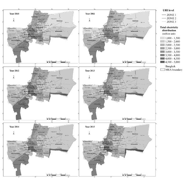
The research aims to study the urban heat island in Bangkok using remote sensing and Geo-information sciences, to determine the relationship between the UHI phenomenon and energy consumption and establish an electricity conservation plan. In this study, we investigated electricity consumption, solar radiation intensity, climate data, land surface temperature data, and land cover change. The quantified LST obtained from satellite imagery is used to identify areas exposed to the UHI effect. The quantified data is validated through field and observed measurements. We also illustrate LST spatial distribution and subsequent land use land cover types related to high LST. The relationship between LST, the Normalized Difference Vegetation Index, and the Normalized Difference Built Index was analyzed. LST was measured and correlated with climate data from meteorological stations. The relationship between increased LST and energy consumption was illustrated through linear regression analysis.
In the results, the energy consumption and UHI illustrate a positive relationship. Electricity consumption and LST have a high correlation of 70-90%. In the hope to mitigate the UHI effect, appropriate mitigation measures are needed to minimize its impact. Mitigation measures such as the reduction of electricity consumption by encouraging citizens to be more conscious of air conditioning use and private transportation use. Another mitigation measure is incorporating sustainable urban planning principles techniques into urban expansion such as increasing urban green spaces and the use of public transportation.
Downloads
References
Akbari, H., Cartalis, C., Kolokotsa, D., Muscio, A., Pisello, A.L., Rossi, F., Santamouris, M., Synnefa, A., Wong, N. H., & Zinzi, M. (2016a). Local climate change and urban heat island mitigation techniques–the state of the art. Journal of Civil Engineering and Management, 22(1), 1-16.
Akbari, H., Rosenfeld, A., Taha, H., & Gartland, L. (2016b). Mitigation of summer urban heat islands to save electricity and smog. Paper presented at the 76th Annual Meteorological Society Meeting. Atlanta, Georgia.
Arifwidodo, S. D. (2015). Factors contributing to urban heat Island in Bangkok, Thailand. Journal of Engineering and Applied Sciences, 10(15), 6435-6439.
Arifwidodo, S. D., & Tanaka, T. (2015). The characteristics of urban heat Island in Bangkok, Thailand. Procedia - Social and Behavioral Sciences, 195, 423-428. DOI: 10. 1016/j.sbspro.2015.06.484.
Bhatti, S. S., & Tripathi, N. K. (2014). Built-up area extraction using Landsat 8 OLI imagery. GIScience & Remote Sensing, 51(4), 445–467.
Boonjawat, J., Niitsu, K., & Kubo, S. (2000). Urban heat island: thermal pollution and climate change in Bangkok. Journal of health science, 9(1), 49-55.
Estoque, R. C., & Murayama, Y. (2017). Monitoring surface urban heat island formation in a tropical mountain city using Landsat data (1987–2015). ISPRS Journal of Photogrammetry and Remote Sensing, 133, 18-29.
Jongtanom, Y., Kositanont, C., & Baulert, S. (2011). Temporal variations of urban heat Island intensity in three major cities, Thailand. Modern Applied Science, 5 (5). DOI: 10.5539/mas.v5n5p105.
Kuttler, W. (2008). The urban climate - basic and applied aspects. In J. M. Marzluff, E. Shulenberger, W. Endlicher, M. Alberti, G. Bradley, C. Ryan, U. Simon, & C. ZumBrunnen (Eds.), Urban Ecology (pp. 233-248). Springer, US. DOI: 10.1007/978-0-387-73412-5.
Landsat 7 (L7) Data Users Handbook. (2018). Version 1.0, Department of the Interior, U.S. Geological Survey, pp. 78-81. Washington, USA: Author.
Li, X., Li, W., Middel, A., Harlan, S. L., Brazel, A. J., & Turner, B. L. (2016). Remote sensing of the surface urban heat island and land architecture in Phoenix, Arizona: Combined effects of land composition and configuration and cadastral–demographic–economic factors. Remote Sensing of Environment, 174, 233-243.
Liao, W., Liu, X., Wang, D., & Sheng, Y. (2017). The impact of energy consumption on the surface urban heat island in China’s 32 major cities. Remote Sensing, 9(3), 250.
Lin, W.-Z., Tsai, H.-C., Wang, C.-H., & Wu, K.-Y. (2005). The subtropical urban heat island effect revealed in eight major cities of Taiwan. In, WSEAS International Conference on Environment, Ecosystems and Development (pp. 14-20). Venice, Italy.
Magli, S., Lodi, C., Contini, F. M., Muscio, A., & Tartarini, P. (2016). Dynamic analysis of the heat released by tertiary buildings and the effects of urban heat island mitigation strategies. Energy and Buildings, 114, 164-172.
Murphy, D. J., Hall, M. H., Hall, C. A. S., Heisler, G. M., Stehman, S. V., & Anselmi-Molina, C. (2011). The relationship between land cover and the urban heat island in northeastern Puerto Rico. International Journal of Climatology, 31(8), 1222-1239. DOI: 10.1002/joc.2145.
National Statistics Office. (2012). The 2010 population and housing census. Bangkok, Thailand: Author.
Peng, S., Piao, S., Ciais, P., Friedlingstein, P., Ottle, C., Bréon, F.o.-M., Nan, H., Zhou, L., & Myneni, R. B. (2011). Surface urban heat island across 419 global big cities. Environmental Science & Technology, 46(2), 696-703.
Sheng, L., Tang, X., You, H., Gu, Q., & Hu, H. (2017). Comparison of the urban heat island intensity quantified by using air temperature and Landsat land surface temperature in Hangzhou, China. Ecological Indicators, 72, 738-746.
Srivanit, M., Hokao, K., & Phonekeo, V. (2012). Assessing the impact of urbanization on ubran thermal environment: A case study of Bangkok Metropolitan. nternational Journal of Applied Sicence and Techonology, 2(7), 243-256.
Srivanit, M., & Kazunori, H. (2011). The Influence of Urban Morphology Indicators on Summer Diurnal Range of Urban Climate in Bangkok Metropolitan Area, Thailand.International Journal of Civil & Environmental Engineering, 11(5), 34-46.
United Nations. (2014). World urbanization prospects: The 2014 revision, highlights. Department of Economic and Social Affairs. Population Division, USA.: Authors.
United States Geological Survey [USGS]. (2016). Landsat 8 (L8) data users handbook (LSDS-1574 version 2.0). USGS Landsat User Services. USA.: Authors. Retrieved from http://www.webcitation.org/6mu9r7riR.
Wan, Z. (2013). Collection-6 MODIS land surface temperature products users’ guide, ERI. California, USA: University of California, Santa Barbara.
Wang, Y., Berardi, U., & Akbari, H. (2016). Comparing the effects of urban heat island mitigation strategies for Toronto. Canada. Energy and Buildings, 114, 2-19.
Wangpattarapong, K., Maneewan, S., Ketjoy, N., & Rakwichian, W. (2008). The impacts of climatic and economic factors on residential electricity consumption of Bangkok Metropolis. Energy and Buildings, 40(8), 1419-1425.
Weng, Q. (2012). Remote sensing of impervious surfaces in the urban areas: Requirements, methods, and trends. Remote Sensing of Environment, 117, 34–49.
Xiong, Y., Huang, S., Chen, F., Ye, H., Wang, C., & Zhu, C. (2012). The impacts of rapid urbanization on the thermal environment: A remote sensing study of Guangzhou, South China. Remote Sensing, 4(7), 2033-2056.
Zhang, X., Estoque, R. C., & Murayama, Y. (2017). An urban heat island study in Nanchang City, China based on land surface temperature and social-ecological variables. Sustainable Cities and Society, 32, 557-568. DOI: 10.1016/j.scs.2017.05.005.

Downloads
Published
How to Cite
Issue
Section
License

This work is licensed under a Creative Commons Attribution-NonCommercial-NoDerivatives 4.0 International License.


