Google Earth Engine for Monitoring Drought Impacts on Urban Tree Using the Standardized Vegetation Index (SVI) in Amphoe Mueang, Nakhonratchasima Province, Thailand
Keywords:
Google Earth Engine, Drought, Urban Tree, Standardized Vegetation Index, Terra/MODIS satelliteAbstract
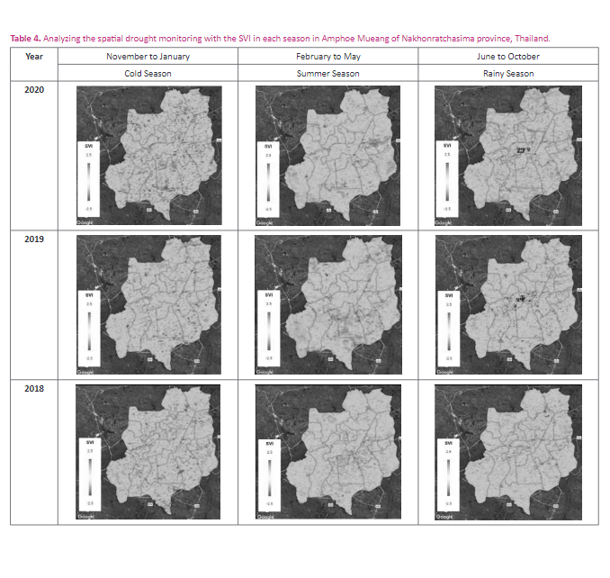
The study aimed to apply the Google Earth Engine (GEE) for monitoring drought impacts on urban tree with the Standardized Vegetation Index (SVI) for long-term and near real-time period in Amphoe Mueang, Nakhonratchasima Province, Thailand. Terra/MODIS satellites from 2000 to recently were analyzed and accessed drought impacts on urban tree in the study area. The results of this study indicated that the SVI values (-2.50 to -1.50) in the condition of very high drought were found mostly in 2019, especially in summer season and with an increasing trend of higher drought in the middle of the study area (Tambon Nai Mueang) and in the south part of the study area (Tambon Nong Chabok, Pho Klang, and Nong Bua Sala) where should be seriously realized and considered on coming dry conditions. Based on the SVI timeseries, the condition of high drought (-1.5 to -0.5) was obviously found in years of 2002, 2005, 2015, 2016, and 2019. In addition, the study demonstrated that the GEE could display the SVI image of the whole timescale in the map section and can receive a pixel value from the visualized SVI images by clicking on a location within the study area in long-term and near real-time period. Conclusively, the application of the GEE for monitoring drought impacts on urban tree can be an efficiency tool for planning urban management to mitigate the impact of drought on urban tree and is helpful to take care of tree growth in urban area.Downloads
References
Anyamba, A., & Tucker, C. J. (2012). Historical perspective of AVHRR NDVI and vegetation drought monitoring. Remote Sens Drought: Innovative Monit Approaches, 23.
Bowler, D.E., Buyung-Ali, L., Knight, T. M., & Pullin, A.S. (2010). Urban greening to cool towns and cities: A systematic review of the empirical evidence. Landscape and Urban Planning, 97(3), 147–155.
Brune, M. (2016). Urban trees under climate change. Potential impacts of dry spells and heat waves in three German regions in the 2050s. Report 24. Climate Service Center Germany, Hamburg.
Byun, H. R., & Wilhite, D. A. (1996). Daily quantification of drought severity and duration. J. Clim.; 5, 1181–1201.
Chen, T., van der Werf, G. R., de Jeu, R. A. M., Wang, G., &Dolman, A. J. (2013). A global analysis of the impact of drought on net primary productivity. Hydrol. Earth Syst. Sci.17: 3885–3894.
Chotchaiwong, P., & Wijitkosum, S. (2019). Relationship between land surface temperature and land use in Nakhon Ratchasima City, Thailand. Engineering Journal;Vol.23(4): 1-14.
Columbia Business School and Columbia University. (2003).Statistical Sampling and Regression: t-Distribution. Retrieved from: http://ci.columbia.edu/ci/premba_test/c0331/s7/s7_4.html.
Department of the Interior. (2020). Statistics, population, and house statistics for the year 2019.
Didan, K., Munoz, A. B., Solano, R., & Huete, A. (2015). MODIS Vegetation Index User’s Guide. Vegetation Index and Phenology Lab. The University of Arizona. Retrieved from https://lpdaac.usgs.gov/documents/103/MOD13_User_Guide_V6.pdf
Doick, K., & Hutchings, T. (2013). Air temperature regulation by urban trees and green infrastructure, Farnham: Forestry Commission (UK). 1-10 pages. Available at: http://www.forestry.gov.uk/PDF/FCRN012.pdf/$FILE/FCRN012.pdf [Accessed January 8, 2015].
Gao, Y., Markkanen, T., Thum, T., Aurela, M., Lohila, A., Mammarella, I., Kämäräinen, M., Hagemann, S., & Aalto,T. (2016). Assessing various drought indicators in representing summer drought in boreal forests in Finland. Hydrology and Earth System Sciences; 20, 175–191.
Gill, S. E., Handley, J. F., Ennos, A. R., & Pauleit, S. (2014). Adapting The Role Cities for Climate of the Green Change: Infrastructure. Built Environment, 33(1), 115–133.
Gorelick, N., Hancher, M., Dixon, M., Ilyushchenko, S., Thau, D., & Moore, R. (2017). Google Earth Engine: Planetary- scale geospatial analysis for everyone. Remote Sens.Environ.; Vol. 202, 18–27.
Hansen, M. C., Patel, N. N., Joshi, A. R., Huang, H., & Xiong, J. (2013). High-resolution global maps of 21st-century forest cover change. Science; Vol. 850: 2011–2014.
Hao, Z. C., & AghaKouchak, A. (2013). Multivariate Standardized Drought Index: A parametric multi-index model. Adv. Water Resour.; 57, 12–18.
Huang, H., Chen, Y., Clinton, N., Wang, J., Wang, X., Liu, C., Gong, P., Yang, J., Bai, Y., Zheng, Y., & Zhu, Z. (2017). Mapping major land cover dynamics in Beijing using all landsat images in Google Earth Engine. Remote Sens. Environ.; Vol.202: 166–176.
Intasen, M., Hauer, R. J., Werner, L. P., & Larsen, E. (2016). Urban forest assessment in Bangkok, Thailand. Journal of Sustainable Forestry; Vol. 36(2).
Jantakat, Y., Juntakut, P., & Kranka, S. (2018). Applied Geo- Informatics Technology to Urban Green Space Management on Role of Stormwater Runoff Reducing and Increasing of Subsurface Water. 2nd Conference on Geoinformatics, Feb. 1-2 in Bangkok, Thailand; 15-24.
Jantakat, Y., Juntakut, P., Plaiklang, S., Arree, W., & Jantakat, C. (2019). Spatiotemporal Change of Urban Agriculture using Google Earth Imagery: A Case of Municipality of Nakhonratchasima City, Thailand. The International Archives of the Photogrammetry, Remote Sensing and Spatial Information Sciences, Vol. XLII-2/W13. ISPRS Geospatial Week 2019, 10-14 June, Enschede, The Netherlands; 1301-1306.
Jantakat, Y., Juntakut, P., Kisanthia, P., & Udom, K. (2020). Application of Geographic Information System via Web for Class of Local Resource and Environmental Management. The Journal of Spatial Innovation Development; Vol. 1(2): 70-82.
Jantakat, Y., Hudkhuntod, T., Muankhamla, A., Mangkalanan,S., Garcia, L. E., Srithumma, K., Rengprapan, S., & Juntakut, P. (2021). ArcGIS Web-based Rapid Application Development for Presenting Urban Street Trees on Sidewalks. International Journal of Building, Urban, Interior and Landscape Technology (BUILT), 17, 29-40. Retrieved from https://ph02.tci-thaijo.org/index.php/BUILT/article/view/244005
Kleerekoper, L., van Esch, M., & Salcedo, T. B. (2012). How to make a city climate-proof, addressing the urban heat island effect. Resources, Conservation and Recycling, 64, 30-38.
Kogan, F. N. (1995). Droughts of the late 1980s in the United States as derived from NOAA polar-orbiting satellite data. Am. Meteorol; 76: 655–668.
Kogan, F., & Guo, W. (2015). Agricultural Drought Detection and Monitoring Using Vegetation Health Methods. In Remote Sensing of Water Resources, Disasters, and Urban Studies; THENKABAIL P.S., Ed.; CRC Press: Boca Raton, FL, USA: 339.
Kumar, L., & Mutanga, O. (2018). Google Earth Engine applications since inception: Usage, trends, and potential. Remote Sens.; Vol. 10(10).
McKee, T. B., Doesken, N. J., & Kleist, J. (1993). The relationship of drought frequency and duration to time scales. In Proceedings of the Eighth Conference on Applied Climatology, Boston, MA, USA, 17–22 Jan.: 179–184.
Nam, W. H., Choi, J. Y., Yoo, S. H., & Jang, M. W. (2012). A decision support system for agricultural drought management using risk assessment. Paddy Water Environ.; 10, 197–207.
Palmer, W.C. (1965). Meteorological Drought. White R.M., Ed.; U.S. Weather Bureau: Washington, DC, USA.
Park, J. S., Kim, K. T., & Choi, Y. S. (2008). Application of Vegetation Condition Index and Standardized Vegetation Index for Assessment of Spring Drought in South Korea, in IGARSS 2008-2008 IEEE International Geoscience and Remote Sensing Symposium, 3: 774.
Patel, N. N., Angiuli, E., Gamba, P., Gaughan, A., Lisini, G.,Stevens, F. R., Tatem, A. J., & Trianni, G. (2015). Multitemporal settlement and population mapping from Landsat using Google Earth Engine. Int. J. Appl. Earth Observ. Geoinf.; Vol.35: 199–208.
Pekel, J. F., Cottam, A., Gorelick, N., & Belward, A. S. (2016). High-resolution mapping of global surface water and its long-term changes. Nature; Vol.540(7633): 418–422.
Peters, J. A., Walter-Shea, E. A., Ji, L., Andres, V., Michael, H., & Svoboda, M. D. (2002). Drought Monitoring with NDVI-Based Standardized Vegetation Index. Photogrammetric Engineering & Remote Sensing, 68(1): 71.
Rimkus, E., Stonevicius, E., Kilpys, J., Maciulyte, V., & Valiukas, D. (2017). Drought identification in the eastern Baltic region using NDVI. Earth System Dynamics; 8, 627–637.
Sazib, N., Mladenova, L., & Bolten, J. (2018). Leveraging the Google Earth Engine for Drought Assessment Using Global Soil Moisture Data. Remote Sens; 10(8), 1265.
Thai Meteorological Department. (2021). Climatological Center. Retrieved from http://climate.tmd.go.th/map/thailand
Trek, S. (2018). Statistics and probability. Retrieved from: https://stattrek.com/
Tsakiris, G., Pangalou, D., & Vangelis, H. (2007). Regional drought assessment based on the Reconnaissance Drought Index (RDI). Water Resour. Manag.; 21, 821–833.
United Nations Office for Outer Space Affairs. (2020). Knowledge Portal. Retrieved from https://www.un-spider.org/advisory-support/recommended-practices/recommended-practice-drought-monitoring-using-standard
Vaz Monteiro, M., Handley, P., Morison, J. I. L., & Doick, K. J. (2019). The role of urban trees and greenspaces in reducing urban air temperatures. Forest Research. ISBN: 978-0-85538-984-0.
Vicente, S. S. M., Begueria, S., & Lopez-Moreno, J. I. (2010). A multiscalar drought index sensitive to global warming: The Standardized Precipitation Evapotranspiration Index. J. Clim; 23: 1696–1718.
Wang, J. J., & Meng, Y. B. (2013). An analysis of the drought in Yunnan, China, from a perspective of society drought severity. Nat. Hazards, 67: 431–458.
Wang, Q. F., Wu, J. J., Lei, T. J., He, B., Wu, Z. T., Liu, M., Mo, X. Y., Geng, G. P., Li, X. H., & Zhou, H. K. (2014). Temporal- spatial characteristics of severe drought events and their impact on agriculture on a global scale. Quat. Int. 349: 10–21.
Wijitkosum, S., & Sriburi, T. (2008). Impact of urban expansion on water demand: The case study of Nakhon Ratchasima city, Lam Ta Kong Watershed. Nakhara: Journal of Environmental Design and Planning; Vol.4: 69-88.
Wu, J. J., Zhou, L., Liu, M., Zhang, J., Leng, S., & Diao, C. Y. (2013). Establishing and assessing the Integrated Surface Drought Index (ISDI) for agricultural drought monitoring in mid-eastern China. Int. J. Appl. Earth Obs.; 23, 397- 410.
Xiong, J., Thenkabail, S., Gumma, M. K., Teluguntla, P., Poehnelt, J., Congalton, R. G., Yadav, K., & Thau, D. (2017). Automated cropland mapping of continental Africa using Google Earth Engine cloud computing. ISPRS J. Photogramm. Remote Sens.; Vol.126: 225–244.
Zhang, Z. X., Chen, X., Xu, C. Y., Hong, Y., Hardy, J., & Sun, Z. H. (2015). Examining the influence of river-lake interaction on the drought and water resources in the Poyang Lake basin. J. Hydrol. 522: 510–521.
Downloads
Published
How to Cite
Issue
Section
License
Copyright (c) 2021 International Journal of Building, Urban, Interior and Landscape Technology (BUILT)

This work is licensed under a Creative Commons Attribution-NonCommercial-NoDerivatives 4.0 International License.