QGIS Simulation Using Openstreetmap Data on Pedestrian Routes from Schools to Green Open Spaces
DOI:
https://doi.org/10.56261/built.v23.256899Keywords:
urban, green open space, pedestrian path, QGIS, shortest route, schoolAbstract
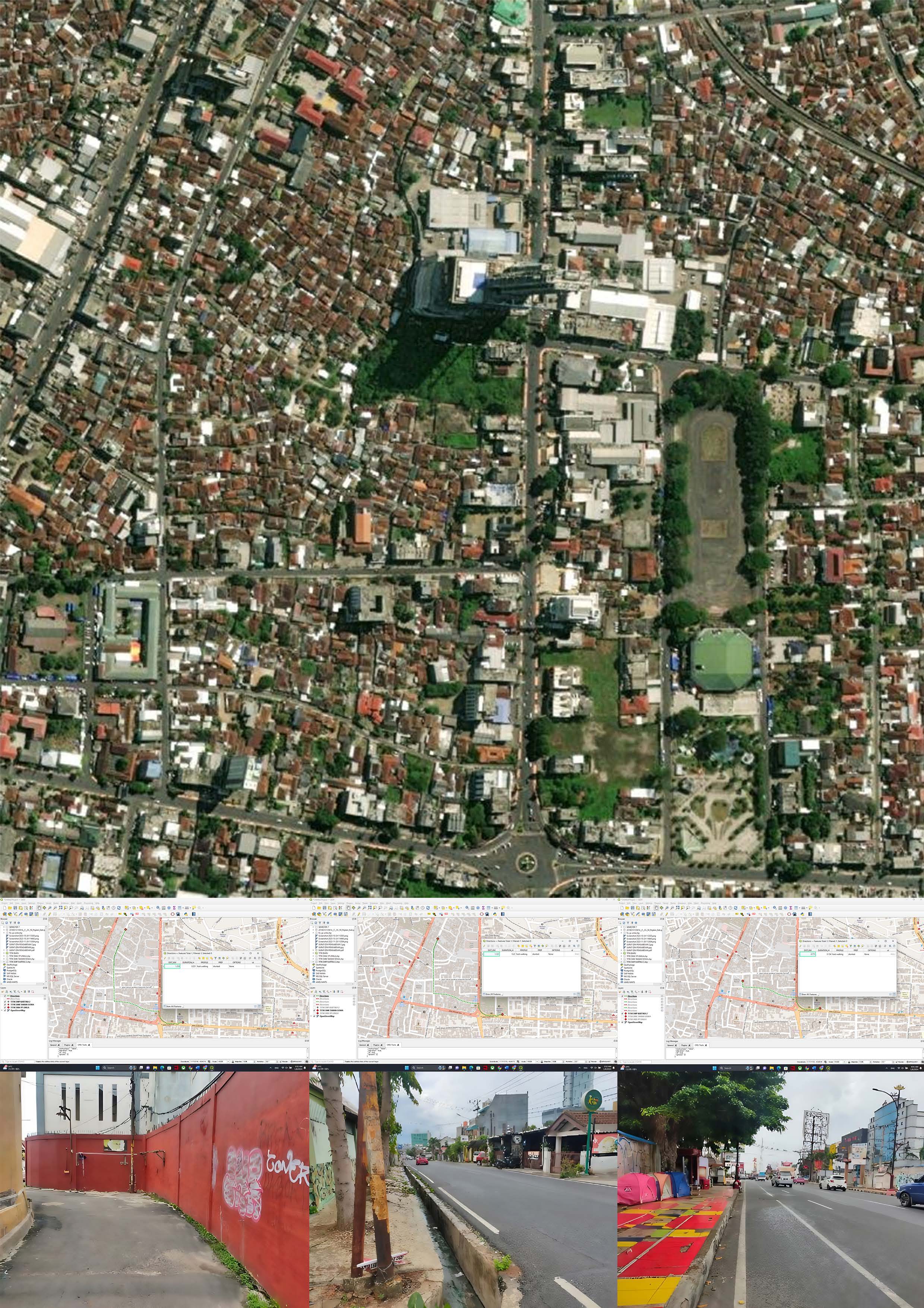
Green open spaces play an important role in modern urban development, benefiting both the ecology and the quality of life of city dwellers. Functional pedestrian path is an important element to support the accessibility of green open spaces. Commonly in Indonesia, green open spaces are isolated and disconnected from pedestrian path network. This research used spatial analysis combined with descriptive method to elaborate systematically and factually, regarding the accessibility of the fastest and shortest routes of pedestrian paths from selected schools to Lampung Elephant Park in Bandar Lampung, as the observed green open spaces. Authors suggested that the connection between schools and green open spaces is important in relation to facilitated environmental and physical education. Field observations and software simulation using QGIS based on OpenStreetMap were utilized to analyse the existing pedestrian path and to indicate the shortest routes. The simulation could suggest routes that accommodate comfortable walking times. The findings from this research can serve as valuable recommendations for urban planning, specifically aimed at enhancing pedestrian accessibility to green open spaces. Priority could be given to improving walking infrastructure along the proposed pedestrian pathways by closely addressing any unmet requirements. Future studies will explore advanced simulation techniques to further refine and optimize these recommendations.
Downloads
References
Afaar, V. M. (2015). Studi ruang terbuka hijau di Kabupaten Mimika berdasarkan Rencana Tata Ruang Wilayah Kabupaten Mimika [English Title] [Unpublished master's thesis]. Universitas Atma Jaya Yogyakarta. http://e-journal.uajy.ac.id/id/eprint/6933 (In Indonesian)
Aronoff, S. (1989). Geographic informations Systems: A management perspective. WDL Publications. https://books.google.co.id/books?id=8e9OAAAAMAAJ DOI: https://doi.org/10.1080/10106048909354237
Arsanjani, J. J., Zipf, A., Mooney, P., & Helbich, M. (2015). An introduction to OpenStreetMap in geographic information science: Experiences, research, and applications. In A. and M. P. and H. M. Jokar Arsanjani Jamal and Zipf (Ed.), OpenStreetMap in GIScience: Experiences, research, and applications (pp. 1–15). Springer International Publishing. https://doi.org/10.1007/978-3-319-14280-7_1 DOI: https://doi.org/10.1007/978-3-319-14280-7_1
Brown, E., & Shortell, T. (Eds.). (2016). Walking in cities: Quotidian mobility as urban theory, method, and practice. Temple University Press. https://doi.org/10.2307/j.ctvrdf2qs DOI: https://doi.org/10.2307/j.ctvrdf2qs
Burrough, P. A. (1986). Principles of geographical information systems for land resources assessment. Clarendon Press. https://books.google.co.id/books?id=KsMsAQAAMAAJ DOI: https://doi.org/10.1080/10106048609354060
Christiyandi, A. (2022). Ketersediaan Ruang Terbuka Hijau Publik Kota Bandar Lampung. Seminar Nasional Insinyur Profesional (SNIP) [English Title] , 2(1). https://doi.org/10.23960/snip.v2i1.82 (In Indonesian) DOI: https://doi.org/10.23960/snip.v2i1.82
Ehrig-Page, J. C. (2020). Evaluating methods for downloading OpenStreetMap data. Cartographic Perspectives, (95), 42–49. https://doi.org/10.14714/CP95.1633 DOI: https://doi.org/10.14714/CP95.1633
Farhana, F. Z. (2019). Pengaruh Pembelajaran Di Ruang Terbuka Hijau Terhadap Motivasi Belajar Siswa [English Title] . Jurnal Tata Kelola Pendidikan, 1(2), 102-106. https://ejournal.upi.edu/index.php/jtkp/article/view/37503 (In Indonesian) DOI: https://doi.org/10.17509/jtkp.v2i2.37503
Foody, G., See, L., Fritz, S., Mooney, P., Olteanu-Raimond, A.-M., Fonte, C. C., & Antoniou, V. (2017). Mapping and the Citizen Sensor. Ubiquity Press. https://doi.org/10.5334/bbf DOI: https://doi.org/10.5334/bbf
Gunawan, R. A., Nuzir, F. A., & Gao, W. (2019). Pedestrian disaster evacuation route for individuals with different abilities in Wakamatsu. Jailcd, May. https://www.researchgate.net/profile/Rachmat-Gunawan-3/publication/333161716_Pedestrian_Disaster_Evacuation_Route_for_Individuals_With_Different_Abilities_in_Wakamatsu/links/5cde4d4092851c4eaba69d1b/Pedestrian-Disaster-Evacuation-Route-for-Individuals-With-Different-Abilities-in-Wakamatsu.pdf
Ischak, M., & Burhannudinnur, M. (2020). Upaya Meningkatkan Pengetahuan Dan Kesadaran Masyarakat Tentang Pentingnya Ruang Terbuka Hijau Di Permukiman Padat [English Title] . Jurnal AKAL : Abdimas Dan Kearifan Lokal, 1(1), 6–17. https://doi.org/10.25105/akal.v1i1.7746 (In Indonesian) DOI: https://doi.org/10.25105/akal.v1i1.7746
Iswanto, D. (2003). Mengkaji fungsi keamanan dan kenyamanan bagi pejalan kaki di jalur pedestrian (trotoar) Jalan Ngesrep Timur V Semarang (akses utama Kampus UNDIP Tembalang) [English Title] [Unpublished master's thesis]. Universitas Diponegoro, Semarang, Indonesia. http://eprints.undip.ac.id/14855/ (In Indonesian)
Lindén, P. (2021). Improving accessibility to the bus service: Building an accessibility measurement tool in QGIS [Unpublished master’s thesis]. Umeå University, Umeå, Sweden. https://umu.diva-portal.org/smash/get/diva2:1572503/FULLTEXT01.pdf
Nuzir, F. A., & Dewancker, B. (2015). Re-Finding PL.AC.E. for Walking: Assessment of Key-Elements using questionnaire. Current Urban Studies, 3(4), 267–285. DOI: https://doi.org/10.4236/cus.2015.34023
Nuzir, F. A., & Dewancker, B. (2016a). A Study on pedestrian’s profile, activity, and environment by descriptive analysis of questionnaire datasets in Kitakyushu, Japan. International Journal of Building, Urban, Interior and Landscape Technology (BUILT), 7, 23–34. https://ph02.tci-thaijo.org/index.php/BUILT/article/view/169281
Nuzir, F. A., & Dewancker, B. J. (2016b). Redefining place for walking: A literature review and key-elements conception. Theoretical and Empirical Researches in Urban Management, 11(1), 59–76. http://www.jstor.org/stable/24873549
Petersen, R. (2004). Sustainable transport: A sourcebook for policy-makers in developing cities. Module 2a: Land use planning and urban transport. Deutsche Gesellschaft für Technische Zusammenarbeit (GTZ).
Pooley, C., Tight, M., Jones, T., Horton, D., Scheldeman, G., Jopson, A., Mullen, C., Chisholm, A., Strano, E., & Constantine, S. (2014). Understanding walking and cycling: Summary of key findings and recommendations. Lancaster University. https://api.semanticscholar.org/CorpusID:128296271 DOI: https://doi.org/10.2307/j.ctt1t6p71q
Sasongko, W., Ramadhani, N.A., & Kurniawan, E. B. (2022). Kajian Tingkat Walkability Jalur Pejalan Kaki Di Kawasan Cbd Bintaro Jaya, Kota Tangerang Selatan [English Title] . Tata Kota dan Daerah, 14(2), 127–134. https://doi.org/10.21776/ub.takoda.2022.014.02.9 (In Indonesian) DOI: https://doi.org/10.21776/ub.takoda.2022.014.02.9
Syiko, S. F., Ayu R, T., & Yudono, A. (2013). Evacuation Route planning in Mount Gamalama, Ternate Island-Indonesia. Procedia Environmental Sciences, 17, 344–353. https://doi.org/10.1016/j.proenv.2013.02.047 DOI: https://doi.org/10.1016/j.proenv.2013.02.047
Downloads
Published
How to Cite
Issue
Section
License
Copyright (c) 2025 International Journal of Building, Urban, Interior and Landscape Technology

This work is licensed under a Creative Commons Attribution-NonCommercial-NoDerivatives 4.0 International License.