Use of Hot Spot Analysis to Detect Underground Coal Fires from Landsat-8 TIRS Data: A Case Study in the Khanh Hoa Coal Field, North-East of Vietnam DOI: 10.32526/ennrj.17.3.2019.17
Article Sidebar
Main Article Content
Abstract
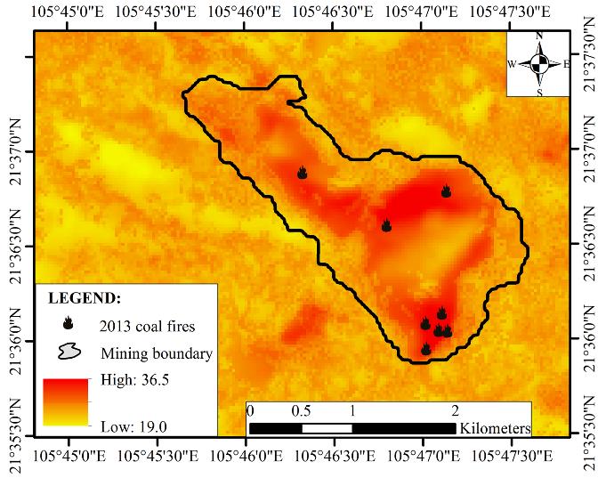
Underground coal fire (UCF) detection from remotely sensed data plays an important role in controlling and preventing the effects of coal fires and their environmental impact. The limitation of commonly used methods does not take into account spatial autocorrelation among observations. For solving this limitation, a method for UCF detection was proposed using hot spot analysis (HSA). Based on the radiative transfer equation (RTE), land surface temperatures (LSTs) were firstly retrieved from the Landsat-8 TIRS data. The degree of spatial clustering among these LSTs was measured using HSA. UCF areas were then delineated based on 99 percent confidence level of hot spot areas. These fires were finally validated using known UCF sites and cross-validated with the results extracted from the ASTER TIR image. It was found from a case study in the Khanh Hoa coal field (North-East of Vietnam); (i) UCFs were strongly correlated with known coal fires and were highly consistent with those obtained from the ASTER TIR data; (ii) a total fire area of 197 hectares was detected, of which the fire areas of low, medium, high and extremely high levels were 37.3, 47.3, 53.2 and 59.3 hectares respectively; (iii) these fires were mainly detected in the central area and at coal ash dump sites of the southern coal field. The results show HSA can be used to effectively detect UCFs.
Article Details
Published articles are under the copyright of the Environment and Natural Resources Journal effective when the article is accepted for publication thus granting Environment and Natural Resources Journal all rights for the work so that both parties may be protected from the consequences of unauthorized use. Partially or totally publication of an article elsewhere is possible only after the consent from the editors.
References
2. Barsi JA, Barker JL, Schott JR. An atmospheric correction parameter calculator for a single thermal band earth-sensing instrument. Proceedings of the International Geoscience and Remote Sensing Symposium (IGARSS); 2003 Jul 21-25; Toulouse, France: New York: IEEE; 2003.
3. Bhattacharya A, Reddy S, Mukherjee T. Multi-tier remote sensing data analysis for coal fire mapping in Jharia coal field of Bihar, India. Proceedings of the Twelfth Asian Conference on Remote Sensing; 1991 30th Oct - 5th Nov; National University of Singapore, Singapore: 1991.
4. Chatterjee A, Bhattacharya A, Mukherjee A, Pramanik T. Study of coal mine fire in Damodar River basin, India using thermal remote sensing technique. Proceedings of the 38th COSPAR Scientific Assembly; 2010 July 15-18; Bremen, Germany: 2010.
5. Chatterjee R. Coal fire mapping from satellite thermal IR data-a case example in Jharia Coal field, Jharkhand, India. ISPRS Journal of Photogrammetry and Remote Sensing 2006;60:113-28.
6. Ding L, Chen K-L, Liu T, Cheng S-G, Wang X. Spatial-temporal hotspot pattern analysis of provincial environmental pollution incidents and related regional sustainable management in china in the period 1995-2012. Sustainability 2015;7:14385-407.
7. Dozier J. A method for satellite identification of surface temperature fields of subpixel resolution. Remote Sensing of Environment 1981;11:221-9.
8. Du X, Bernardes S, Cao D, Jordan TR, Yan Z, Yang G, Li Z. Self-adaptive gradient-based thresholding method for coal fire detection based on ASTER data - Part 2, validation and sensitivity analysis. Remote Sensing 2015a;7:2602-26.
9. Du X, Cao D, Mishra D, Bernardes S, Jordan TR, Madden M. Self-adaptive gradient-based thresholding method for coal fire detection using ASTER thermal infrared data, part I: methodology and decadal change detection. Remote Sensing 2015b;7:6576-610.
10. Finkelman R, Stracher G. Environmental and health impacts of coal fires. In: Stracher GB, Prakash A, Sokol EV, editors. Coal and Peat Fires: A Global Perspective: Volume 1: Coal-Geology and Combustion. English: Elsevier Science; 2011. p. 115-25.
11. Gangopadhyay PK, Lahiri-Dutt K, Saha K. Application of remote sensing to identify coalfires in the Raniganj Coalbelt, India. International Journal of Applied Earth Observation and Geoinformation 2006;8:188-95.
12. Greene GW, Moxham RM, Harvey AH. Aerial infrared surveys and borehole temperature measurements of coal mine fires in Pennsylvania. Proceedings of the Sixth International Symposium on Remote Sensing of Environment, Volume II. Held; 1969 Oct 13-16; University of Michigan, USA: 1969
13. Huijun D, Shijun H, Jie F. The detection method of fire abnormal based on directional drilling in complex conditions of mine. Proceedings of the 4th International Conference on Energy Materials and Environment Engineering (ICEMEE 2018); 2018 Sep 28-30; Zhuhai, China: 2018.
14. Huo H, Jiang X, Song X, Li Z-L, Ni Z, Gao C. Detection of coal fire dynamics and propagation direction from multi-temporal nighttime Landsat SWIR and TIR data: A case study on the Rujigou coalfield, Northwest (NW) China. Remote Sensing 2014a;6:1234-59.
15. Huo H, Jiang X, Song X, Ni Z, Liu L. Coal fires dynamics detection over Rujigou coalfield, Ningxia, NW China. Proceedings of the IEEE Geoscience and Remote Sensing Symposium (IGARSS); 2014 July 13-18; Quebec City, Canada: 2014b.
16. Huo H, Ni Z, Gao C, Zhao E, Zhang Y, Lian Y, Zhang H, Zhang S, Jiang X, Song X, Zhou P, Cui T. A study of coal fire propagation with remotely sensed thermal infrared data. Remote Sensing 2015;7:3088-113.
17. Jiang W-g, Gu L, Yang B, Chen Q. Monitoring method of underground coal fire based on night thermal infrared remote sensing technology. Spectroscopy and Spectral Analysis 2011;31:357-61.
18. Cheng KL, Hsu SC, Li WM, Ma HW. Quantifying potential anthropogenic resources of buildings through hot spot analysis. Resources, Conservation and Recycling 2018;13:10-20.
19. Kuenzer C, Dech S. Thermal Infrared Remote Sensing: Sensor, Methods, Applications. New York: Springer; 2014.
20. Kuenzer C, Zhang J, Li J, Voigt S, Mehl H, Wagner W. Detecting unknown coal fires: synergy of automated coal fire risk area delineation and improved thermal anomaly extraction. International Journal of Remote Sensing 2007;28:4561-85.
21. Kuenzer C, Zhang J, Sun Y, Jia Y, Dech S. Coal fires revisited: The Wuda coal field in the aftermath of extensive coal fire research and accelerating extinguishing activities. International Journal of Coal Geology 2012;102:75-86.
22. Künzer C, Zhang J, Tetzlaff A, Voigt S, Wagner W. Automated demarcation, detection and quantification of coal fires in China using remote sensing data. In: Stefan V, Horst R, Li JH, Li J, Jayakumar R, editors. Spontaneous Coal Seam Fires: Mitigating a Global Disaster. Beijing: Tsinghua University Press; 2008. p. 362-80.
23. Lu D, Song K, Zang S, Jia M, Du J, Ren C. The effect of urban expansion on urban surface temperature in Shenyang, China: an analysis with landsat imagery. Environmental Modeling and Assessment 2015; 20:197-210.
24. Mitchel A. The ESRI Guide to GIS analysis, Volume 2: Spartial Measurements and Statistics. 1st ed. California, USA: ESRI Press; 2005.
25. Nguyen TT. Use of Moran’s I and robust statistics to separate geochemical anomalies in Jiurui area (Southeast China). Maden Tetkik ve Arama Dergisi 2018;156:181-94.
26. Nguyen TT, Vu DT, Trinh LH, Nguyen TLH. Spatial cluster and outlier identification of geochemical association of elements: A case study in Juirui copper mining area. Bulletin of the Mineral Research and Exploration 2016;153:159-67.
27. Obida CB, Blackburn GA, Whyatt JD, Semple KT. Quantifying the exposure of humans and the environment to oil pollution in the Niger Delta using advanced geostatistical techniques. Environment International 2018;111:32-42.
28. Odland J. Spatial autocorrelation. California, USA: Sage Publications; 1988.
29. Ord JK, Getis A. Local spatial autocorrelation statistics: distributional issues and an application. Geographical Analysis 1995;27:286-306.
30. Pal S, Vaish J, Kumar S, Bharti AK. Coal fire mapping of East Basuria Colliery, Jharia coalfield using vertical derivative technique of magnetic data. Journal of Earth System Science 2016;125:165-78.
31. Pandey J, Kumar D, Panigrahi D, Singh V. Temporal transition analysis of coal mine fire of Jharia coalfield, India, using Landsat satellite imageries. Environmental Earth Sciences 2017;76:439.
32. Peeters A, Zude M, Käthner J, Ünlü M, Kanber R, Hetzroni A. Getis-Ord’s hot-and cold-spot statistics as a basis for multivariate spatial clustering of orchard tree data. Computers and Electronics in Agriculture 2015;111:140-50.
33. Qi G, Wang D, Zheng K, Xu J, Qi X, Zhong X. Kinetics characteristics of coal low-temperature oxidation in oxygen-depleted air. Journal of Loss Prevention in the Process Industries 2015;35:224-31.
34. Roy P, Guha A, Kumar KV. An approach of surface coal fire detection from ASTER and Landsat-8 thermal data: Jharia coal field, India. International Journal of Applied Earth Observation and Geoinformation 2015a;39:120-7.
35. Roy P, Guha A, Kumar KV. Structural control on occurrence and dynamics of Coalmine fires in Jharia Coalfield: a remote sensing based analysis. Journal of the Indian Society of Remote Sensing 2015b;43:779-86.
36. Saini V, Gupta RP, Arora MK. Environmental impact studies in coalfields in India: A case study from Jharia coal-field. Renewable and Sustainable Energy Reviews 2016;53:1222-39.
37. Singh A, Raju A, Pati P, Kumar N. Mapping of coal fire in Jharia coalfield, India: A Remote Sensing Based Approach. Journal of the Indian Society of Remote Sensing 2017;45:369-76.
38. Sobrino JA, Jiménez-Muñoz JC, Sòria G, Romaguera M, Guanter L, Moreno J. Land surface emissivity retrieval from different VNIR and TIR sensors. IEEE Transactions on Geoscience and Remote Sensing 2008;46:316-27.
39. Song Z, Kuenzer C. Spectral reflectance (400-2,500 nm) properties of coals, adjacent sediments, metamorphic and pyrometamorphic rocks in coal-fire areas: A case study of Wuda coalfield and its surrounding areas, Northern China. International Journal of Coal Geology 2017;171:142-52.
40. Song Z, Kuenzer C, Zhu H, Zhang Z, Jia Y, Sun Y. Analysis of coal fire dynamics in the Wuda syncline impacted by fire-fighting activities based on in-situ observations and Landsat-8 remote sensing data. International Journal of Coal Geology 2015;141:91-102.
41. Stopka TJ, Goulart MA, Meyers DJ, Hutcheson M, Barton K, Onofrey S. Identifying and characterizing hepatitis C virus hotspots in Massachusetts: A spatial epidemiological approach. BMC Infectious Diseases 2017;17:294.
42. Su H, Zhou F, Qi H, Li J. Design for thermoelectric power generation using subsurface coal fires. Energy 2017;140:929-40.
43. Team RC. R: A language and environment for statistical computing. R Foundation for Statistical Computing, Vienna, Austria [Internet]. 2016. Available from: ftp://ftp.uvigo.es/CRAN/web/packages/dplR/vignettes/intro-dplR.pdf.
44. Tobler WR. Smooth pycnophylactic interpolation for geographical regions. Journal of the American Statistical Association 1979;74:519-30.
45. Tran DX, Pla F, Latorre-Carmona P, Myint SW, Caetano M, Kieu HV. Characterizing the relationship between land use land cover change and land surface temperature. ISPRS Journal of Photogrammetry and Remote Sensing 2017;124:119-32.
46. Tran VT, Tran DK, Phan QV. Exploitation and management of burning coal seams in underground mines of Vietnam. Proceedings of the Second International Conference on Coal Fire Research (ICCFR 2); 2010 May 19-21; Berlin, Germany: 2010.
47. Trinh LH, Zablotskii V. The application of LANDSAT multi-temporal thermal infrared data to identify coal fire in the Khanh Hoa coal mine, Thai Nguyen province, Vietnam. Izvestiya, Atmospheric and Oceanic Physics 2017;53:1081-7.
48. Tuyen LT, Tuan NV, Ohga K, Isei T. Characteristics of spontaneous combustion of Anthracite in Vietnamese coal mines. Journal of the Mining and Materials Processing Institute of Japan 2016;132:167-74.
49. Voigt S, Tetzlaff A, Zhang J, Künzer C, Zhukov B, Strunz G. Integrating satellite remote sensing techniques for detection and analysis of uncontrolled coal seam fires in North China. International Journal of Coal Geology 2004;59:121-36.
50. Vu HN. Assessment of the Environmental Status in Khanh Hoa Coal Field, Thai Nguyen Province [dissertation]. Thai Nguyen, Vietnam: Thai Nguyen University of Agriculture and Forestry; 2013.
51. Yang B, Chen Y, Li J, Gong A, Kuenzer C, Zhang J. Simple normalization of multi-temporal thermal IR data and applied research, on the monitoring of typical coal fires in northern China. Proceedings of the Geoscience and Remote Sensing Symposium; 2005 July 29-29; Seoul, South Korea: 2005.
52. Zanter K. Landsat 8 (L8) data users handbook. Landsat Science Official Website. 2016. Available from: https://landsat. usgs. gov/landsat-8-l8-data-users-handbook.
53. Zhang H, Tripathi NK. Geospatial hot spot analysis of lung cancer patients correlated to fine particulate matter (PM2.5) and industrial wind in Eastern Thailand. Journal of Cleaner Production 2018; 170:407-24.
54. Zhang X, Cassells C, Van Genderen J. Multi-sensor data fusion for the detection of underground coal fires. Geology and Mining 1998;77:117-28.
