Assessment of Urban Heat Island Patterns in Bangkok Metropolitan Area Using Time-Series of LANDSAT Thermal Infrared Data DOI: 10.32526/ennrj.17.4.2019.34
Article Sidebar
Main Article Content
Abstract
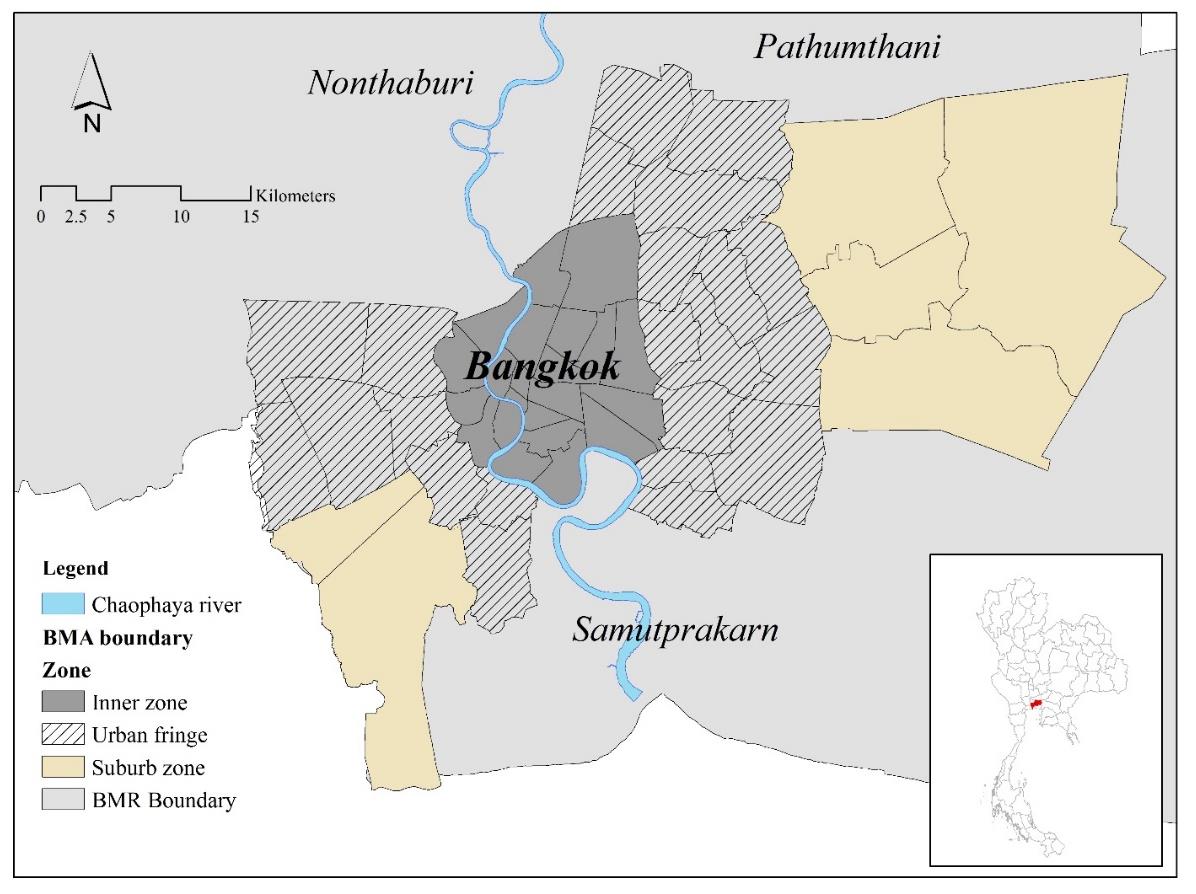
Bangkok is a rapidly expanding city with existing natural areas being replaced by developed areas creating an urban heat island (UHI) phenomenon in the city. LANDSAT imagery, near-infrared wavelength data, and time series information were used to study and to monitor the phenomenon of surface urban heat island (SUHI) in Bangkok. The variation of land surface temperature (LST) and the urban heat island intensity (UHII) phenomenon during 2008-2014 were investigated and the relationship between the UHII phenomenon and urban sprawl in Bangkok was studied. Using the UHII, we compared nine LST images of the investigated areas defined as inner, urban fringe and suburb zones. The UHI in Bangkok in the winter (dry) is higher than in the summer. Satellite imageries were used to classify the land use types as open spaces with high-rise buildings, very high density of buildings and high-rise buildings. Low vegetation index was found in urban fringe areas and inner city area with high surface temperature. The vegetation index value is high in areas of agricultural land, and low density building, it appears in suburb areas with low surface temperature. The results indicate that NDVI and High-rise building zones influence LST distribution and UHII phenomenon.
Article Details
Published articles are under the copyright of the Environment and Natural Resources Journal effective when the article is accepted for publication thus granting Environment and Natural Resources Journal all rights for the work so that both parties may be protected from the consequences of unauthorized use. Partially or totally publication of an article elsewhere is possible only after the consent from the editors.
References
2. Bangkok Information Center. Bangkok Nowadays [Internet]. 2015. Available from: https://www.bangkokgis.com/gis_information/population/ (in Thai).
3. Chayapong P. Spatial Analysis of Urban Heat Island Phenomenon and Its Relationship with Land Use and Land Cover and Electrical Energy Consumption: A Case Study in Bangkok Metropolitan Area [dissertation]. Nakhon Ratchasima, Suranaree University of Technology; 2010.
4. Chen XL, Zhao HM, Li PX, Yin ZY. Remote sensing image-based analysis of the relationship between urban heat island and land use/cover changes. Remote Sensing of Environment 2006;104:133-46.
5. Department of City Planning. Final Report of the Project on BMA Central City Planning (3rd Revision). Bangkok, Department of City Planning BMA; 2011 (in Thai).
6. Grimm NB, Faeth SH, Golubiewski NE, Redman CL, Wu J, Bai X, Briggs JM. Global change and the ecology of cities. Science 2008;319:756-60.
7. Hung T, Uchihama D, Ochi S, Yasuoka Y. Assessment with satellite data of the urban heat island effects in Asian mega cities. International Journal of Applied Earth Observation and Geoinformation 2006;8:34-48.
8. Imhoff ML, Zhang P, Wolfe RE, Bounoua L. Remote sensing of the urban heat island effect across biomes in the continental USA. Remote Sensing Environment 2010;114:504-13.
9. Jiang XD, Xia BC, Guo L. Research on urban heat island and its environmental effects of rapidly urbanized regions. Ecologic Science 2006;25:171-5.
10. Keramitsoglou I, Kiranoudis CT, Ceriola, G, Weng Q, Rajasekar U. Identification and analysis of urban surface temperature patterns in Greater Athens, Greece, using MODIS imagery. Remote Sensing of Environment 2011;115:3080-90.
11. Komonveeraket K. The Effects of Land Cover on Urban Heat Islands in Bangkok Metropolis [dissertation]. Bangkok, Chulalongkorn University; 1998 (in Thai).
12. Li YY, Zhang H, Kainz W. Monitoring patterns of urban heat islands of the fast-growing Shanghai metropolis, China: Using time-series of LANDSAT TM/ETM+ data. International Journal of Applied Earth Observation and Geoinformation 2012;19:127-38.
13. Lo CP, Quattrochi DA, Luvall JC. Application of high-resolution thermal infrared remote sensing and GIS to assess the urban heat island effect. International Journal of Remote Sensing 1997;18:287-304.
14. Manjula R, Ronal CE, Yuji M. An urban heat island study of the Colombo Metropolitan Area, Sir Lanka, based on LANDSAT data(1997-2017). ISPRS International Journal of Geo-Information 2017;6:189.
15. Meng F, Liu M. Remote-sensing image-based analysis of the patterns of urban heat islands in rapidly urbanizing Jinan, China. International Journal of Remote Sensing 2013;34(24):8838-53.
16. National Aeronautics and Space Administration (NASA). Landsat 7 Science Data Users Handbook. Washington D.C., USA: National Aeronautics and Space Administration; 2014.
17. Nichol JE. High-resolution surface temperature patterns related to urban morphology in a tropical city: asatellite-based study. Journal of Applied Meteorology and Climatology 1996;35:135-46.
18. Pongrácz R, Bartholy J, Dezsö Z. Application of remotely sensed thermal information to urban climatology of central European cities. Physics and Chemistry of the Earth 2010;35:95-9.
19. Poolakhon B, Boonyaputthipong C. The comparing of Heat on concrete and asphalt. Proceedings of the 9th Mahasarakham Research Conference; 2013 September 12-13; Bangkok; 2014.
20. Qin Z, Karnieli A, Berliner P. A Mono-window algorithm for retrieving land surface temperature from LANDSAT TM data and its application to the Israel-Egypt border region. International Journal of Remote Sensing 2001;22:3719-46.
21. Song W, Mu X, Ruan G, Gao Z, Li L, Yan G. Estimating fractional vegetation cover and the vegetation index of bare soil and highly dense vegetation with a physically based method. International Journal of Applied Earth Observation and Geoinformation 2017;58:168-76.
22. Streutker DR. A remote sensing study of the urban heat island of Houston, Texas. International Journal of Remote Sensing 2002;23(12):2595-608.
23. Streutker DR. Satellite-measured growth of the urban heat island of Houston, Texas. Remote Sensing of Environment 2003;85:282-9.
24. Teanmanee T. Urban heat island and urban physical environment [dissertation]. Nakhon Pathom, Silpakorn University; 2002 (in Thai).
25. Tongliga B, Xueming L, Jing Z, Yingjia Z, Shenzhen T. Assessing the distribution of urban green spaces and its Anisotropic cooling distance on urban heat island pattern in Baotou, China. ISPRS International Journal of Geo-Information 2016;5(2):12.
26. United States Environmental Protection Agency (U.S. EPA) Reducing Urban Heat Islands: Compendium of Strategies: Chapter 1: Urban Heat Island Basics. USA: United States Environmental Protection Agency; 2012.
27. U.S. Geological Survey (USGS). Landsat 8 Data Users Handbook. USA: US Geological Survey; 2019.
28. Voogt JA, Oke TR. Thermal remote sensing of urban climates. Remote Sensing of Environment 2003;86: 370-84.
29. Weng Q. Thermal infrared remote sensing for urban climate and environmental studies: methods, applications, and trends. ISPRS Journal of Photo-grammetry and Remote Sensing 2009;64:335-44.
30. Weng Q, Fu P, Gao F. Generating daily land surface temperature at LANDSAT resolution by fusing LANDSAT and MODIS data. Remote Sensing of Environment 2014;145:55-67.
31. Weng Q, Liu H, Lu D. Assessing the effects of land use and land cover patterns on thermal conditions using landscape metrics in city of Indianapolis, United States. Urban Ecosystems 2007;10(2):203-19.
32. Weng Q, Lu D, Schubring J. Estimation of land surface temperature-vegetation abundance relationship for urban heat island studies. Remote Sensing of Environment 2004;89(4):467-83.
33. Xu HQ, Chen BQ. Remote sensing of the urban heat island and its changes in Xiamen City of SE China. Journal of Environmental Sciences 2004;16:276-81.
34. Yuan F, Bauer ME. Comparison of impervious surface area and normalized difference vegetation index as indicators of surface urban heat island effects in LANDSAT imagery. Remote Sensing of Environment 2007;106(13):375-86.
35. Zhang L, Meng Q, Sun A, Sun Y. Spatial and temporal analysis of the mitigating effects of industrial relocation on the surface urban heat island over China. ISPRS International Journal of Geo-Information 2017;6(4): 121.
36. Zhou D, Zhao S, Liu S, Zhang L, Zhu C. Surface urban heat island in China’s 32 major cities: spatial patterns and drivers. Remote Sensing of Environment 2014;152:51-61.
