Revision of Vajiralongkorn Dam’s Reservoir Characteristic Curves Using NDWI Derived from Landsat 8 Data DOI: 10.32526/ennrj.18.2.2020.13
Article Sidebar
Main Article Content
Abstract
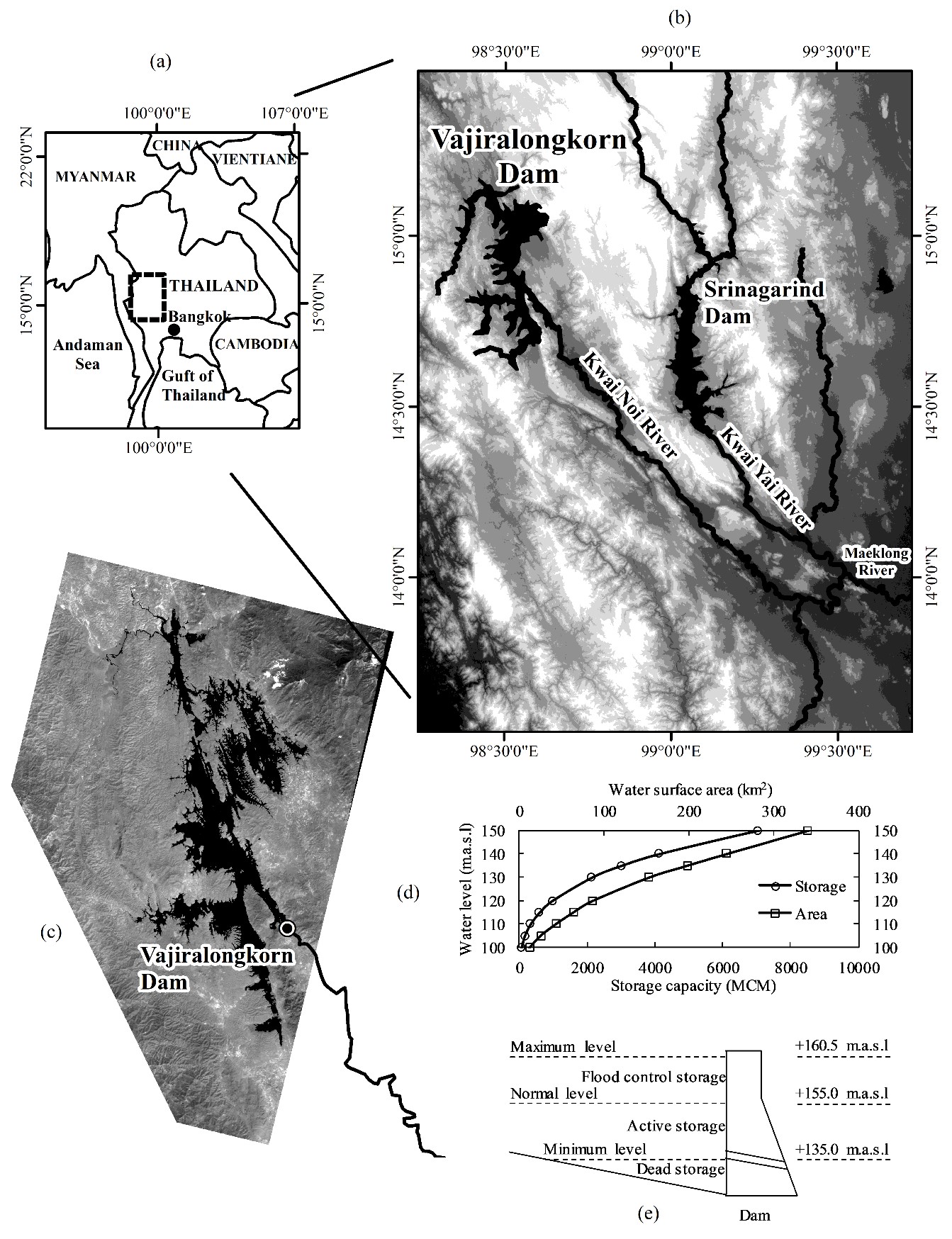
Reservoir characteristics are the essential information for water management planning and reservoir operation. Regular monitoring and assessment of the reservoir characteristics can reduce risks associated with the reservoir operation. This research assessed the reservoir characteristics (water surface, volume) of Vajiralongkorn Dam using remote sensing. Reservoir water surface was classified using the Normalized Difference Water Index (NDWI) derived from the Landsat 8 data, and validated using the streamline matching rate (SMR) and the streamline matching error (SME) techniques for shoreline accuracy assessment. The volume between two water levels was calculated using the prismatic equation. The storage capacity curve was constructed from the reservoir water level and cumulative volume. The accuracy of NDWI technique was satisfactory in identifying reservoir water surface with a good accuracy of shoreline delineation (SMR>95% and SME=11.7 m). The water surface has decreased on the average of 8.2 km2 (2.8%) compared with the original data in 1980. The storage capacity has decreased 495.3 million m3 (MCM) over 38 years from 1980 to 2018, an annual capacity loss of 13 MCM. Finally, sustainable service of the reservoir needs better knowledge of the effects of storage loss, the erosion and sediment-transport processes, and conservation measures.
Article Details
Published articles are under the copyright of the Environment and Natural Resources Journal effective when the article is accepted for publication thus granting Environment and Natural Resources Journal all rights for the work so that both parties may be protected from the consequences of unauthorized use. Partially or totally publication of an article elsewhere is possible only after the consent from the editors.
References
2. Cesare DD, Schleiss A, Hermann F. Impact of turbidity currents on reservoir sedimentation. Journal of Hydraulic Engineering 2001;127(1):6-16.
3. Chander G, Markham BL, Helder DL. Summary of current radiometric calibration coefficients for Landsat MSS, TM, ETM+, and EO-1 ALI sensors. Remote Sensing of Environment 2009;113(5):893-903.
4. Chen Y, Wilson J, Zhu Q, Zhou Q. Comparison of drainage-constrained methods for DEM generalization. Computers and Geosciences 2012;48:41-9.
5. Cui L, Qiu Y, Fei T, Liu Y, Wu G. Using remotely sensed suspended sediment concentration variation to improve management of Poyang Lake, China. Lake and Reservoir Management 2013;29(1):47-60.
6. Deng Z, Sun Y, Zhang K, Qiu Q, Sun W. A water identification method basing on grayscale Landsat 8 OLI images. Geocarto International 2019:1-11.
7. Du Z, Li W, Zhou D, Tian L, Ling F, Wang H, et al. Analysis of Landsat-8 OLI imagery for land surface water mapping. Remote Sensing Letters 2014;5(7):672-81.
8. El-Shazli A, Hoermann G. Development of storage capacity and morphology of the Aswan High Dam Reservoir. Hydrological Sciences Journal 2016;61(14):2639-48.
9. Fan J, Morris GL. Reservoir sedimentation. I: delta and density current deposits. Journal of Hydraulic Engineering 1992a; 118(3):354-69.
10. Fan J, Morris GL. Reservoir sedimentation. II: Reservoir desiltation and long-term storage capacity. Journal of Hydraulic Engineering 1992b;118(3):370-84.
11. Felde GW, Anderson GP, Cooley TW, Matthew MW, Adler-Golden SM, Berk A, et al. Analysis of hyperion data with the FLAASH atmospheric correction algorithm. Proceedings of the International Geoscience and Remote Sensing Symposium (IGARSS); 2003 Jul 21-25; Toulouse, France; 2003.
12. Feyisa GL, Meilby H, Fensholt R, Proud SR. Automated water extraction index: A new technique for surface water mapping using Landsat imagery. Remote Sensing of Environment 2014;140:23-35.
13. Foteh R, Garg V, Nikam BR, Khadatare MY, Aggarwal SP, Kumar AS. Reservoir sedimentation assessment through remote sensing and hydrological modelling. Journal of the Indian Society of Remote Sensing 2018;46(11):1893-905.
14. Gao B-C. NDWI-A normalized difference water index for remote sensing of vegetation liquid water from space. Remote Sensing of Environment 1996;58(3):257-66.
15. Grin S. Geometry and water height-area-volume curves of the reservoirs in the semiarid Madalena basin in Northeast Brazil [Bachelor final project]. Enschede, University of Twente; 2014.
16. Gupta RP, Banerji S. Monitoring of reservoir volume using LANDSAT data. Journal of Hydrology 1985;77(1):159-70.
17. Jain SK, Singh P, Seth SM. Assessment of sedimentation in Bhakra Reservoir in the western Himalayan region using remotely sensed data. Hydrological Sciences Journal 2002;47(2):203-12.
18. Jeyakanthan VS, Sanjeevi S. Reservoir capacity estimation of Singoor reservoir, India, by per-pixel and sub-pixel processing of multi-date satellite images. Geocarto International 2011;26(4):305-20.
19. MacPheson KR, Freeman LA, Flint LE. Analysis of Methods to Determine Storage Capacity of, and Sedimentation in, Loch Lomond Reservoir, Santa Cruz County, California, 2009. Reston, VA: U.S. Geological Survey; 2011.
20. Malarvizhi K, Kumar SV, Porchelvan P. Use of high resolution Google Earth satellite imagery in landuse map preparation for urban related applications. Procedia Technology 2016; 24:1835-42.
21. McFeeters SK. The use of the Normalized Difference Water Index (NDWI) in the delineation of open water features. International Journal of Remote Sensing 1996;17(7):1425-32.
22. Mishra N, Haque M, Leigh L, Aaron D, Helder D, Markham B. Radiometric cross calibration of Landsat 8 operational land imager (OLI) and Landsat 7 Enhanced Thematic Mapper Plus (ETM+). Remote Sensing 2014;6(12):12619-38.
23. Morris GL, Fan J. Reservoir Sedimentation Handbook: Design and Management of Dams, Reservoirs, and Watersheds for Sustainable Use. New York, USA: McGraw-Hill; 1998.
24. Odhiambo BK, Boss SK. Integrated echo sounder, GPS, and GIS for reservoir sedimentation studies: Examples from two Arkansas lakes. Journal of the American Water Resources Association 2004;40(4):981-97.
25. Ortt RA, Kerhin RT, Wells D, Cornwell J. Bathymetric Survey and Sedimentation Analysis of Loch Raven and Prettyboy Reservoirs. Coastal and Estuarine Geology File Report. Baltimore, MD: Maryland Geological Survey; 2000.
26. Ouma YO, Tateishi R. Lake water body mapping with multiresolution based image analysis from medium-resolution satellite imagery. International Journal of Environmental Studies 2007;64(3):357-79.
27. Pandey A, Chaube UC, Mishra SK, Kumar D. Assessment of reservoir sedimentation using remote sensing and recommendations for desilting Patratu Reservoir, India. Hydrological Sciences Journal 2016;61(4):711-8.
28. Peng D, Guo S, Liu P, Liu T. Reservoir storage curve estimation based on remote sensing data. Journal of Hydrologic Engineering 2006;11(2):165-72.
29. Ran L, Lu XX. Delineation of reservoirs using remote sensing and their storage estimate: an example of the Yellow river basin, China. Hydrological Processes 2012;26(8):1215-29.
30. Rodrigues LN, Sano EE, Steenhuis TS, Passo DP. Estimation of small reservoir storage capacities with remote sensing in the Brazilian Savannah region. Water Resources Management 2012;26(4):873-82.
31. Scheffers AM, Kelletat DH. Lakes of the World with Google Earth, Understanding Our Environment. Dordrecht, the Netherlands: Springer; 2016.
32. Su H, Liu H, Heyman WD. Automated derivation of bathymetric information from multi-spectral satellite imagery using a non-linear inversion model. Marine Geodesy 2008;31(4):281-98.
33. United States Geological Survey (USGS). Landsat 8 (L8) Data User’s Handbook. Sioux Falls, SD: Earth Resources Observation and Science Center; 2016.
34. Wu C-H, Chen C-N, Tsai C-H, Tsai C-T. Estimating sediment deposition volume in a reservoir using the physiographic soil erosion-deposition model. International Journal of Sediment Research 2012;27(3):362-77.
35. Zhang F, Li J, Zhang B, Shen Q, Ye H, Wang S, et al. A simple automated dynamic threshold extraction method for the classification of large water bodies from landsat-8 OLI water index images. International Journal of Remote Sensing 2018;39(11):3429-51.
36. Zhou Q, Chen Y. Generalization of DEM for terrain analysis using a compound method. ISPRS Journal of Photogrammetry and Remote Sensing 2011;66(1):38-45.
