Landslide Hazard Mapping in Panchase Mountain of Central Nepal DOI: 10.32526/ennrj.18.4.2020.37
Article Sidebar
Main Article Content
Abstract
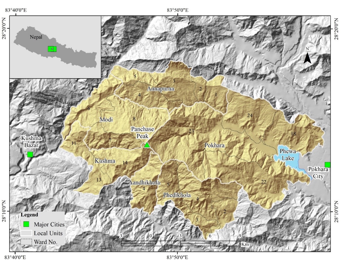
Numerous slope failures have been noticed in the Panchase region of central Nepal posing threats to people and biodiversity. Considering the need to reduce landslide risks, this research determined the spatial extent of landslide hazard degrees in the Panchase area. The research site, with an area of 278.324 km2, consists of parts of the Kaski, Parbat, and Syangja Districts. A Statistical Index Method was used for hazard analysis that produced weights. Positive weight values for each factor class represented a higher hazard and vice versa. An inventory of the study area identified 556 landslides measuring 1.511 km2 indicating a landslide density of 2 per km2 area. Thirteen percent (36.18 km2) of the total experimental area was rated as a very high hazard zone. Similarly, the area occupied by high hazard and moderate hazard zones were 77.66 km2 (28%), and 81.83 km2 (29%) respectively. The validation showed that the method can produce results with of accuracy of 82.8%. This indicated the hazard assessment process is acceptable and replicable. The factor classes having greater influence for higher landslide hazard are: near the streams, near the roads, barren or grassland, land with phyllite bedrocks, land receiving rainfalls greater than 4,000 mm, lands with an elevation range from 1,000 m to 1,500 m, slopes steeper than 30°, and south-facing slope. During risk management work by local authorities, considerations should be given to these factors and areas with higher hazards.
Article Details
Published articles are under the copyright of the Environment and Natural Resources Journal effective when the article is accepted for publication thus granting Environment and Natural Resources Journal all rights for the work so that both parties may be protected from the consequences of unauthorized use. Partially or totally publication of an article elsewhere is possible only after the consent from the editors.
References
Adhikari S, Baral H, Nitschke CR. Identification, prioritization and mapping of ecosystem services in the Panchase Mountain Ecological Region of Western Nepal. Forests 2018;9:Article ID 554.
Alkhasawneh MS, Ngah UK, Tay LT, Mat Isa NA, Al-Batch MS. Determination of important topographic factors for landslide mapping analysis using MLP network. The Scientific World Journal 2013;2013:Article ID 415023.
Basnet P, Balla MK, Pradhan BM. Landslide hazard zonation, mapping and investigation of triggering factors in Phewa lake watershed, Nepal. Banko Janakari 2006;22:43-52.
Bhandari AR, Khadka UR, Kanel KR. Ecosystem services in the mid-hill forests of western Nepal: A case of Panchase Protected Forest. Journal of Institute of Science and Technology 2018;23(1):10-7.
Bhatt BP, Awasthi KD, Heyojoo BP, Silwal T, Kafle G. Using geographic information system and analytical hierarchy process in landslide hazard zonation. Applied Ecology and Environmental Sciences 2013;1(2):14-22.
Bhusan K, Goswami DC. Triggering factors of landslides and determination of rainfall threshold: A case study from northeast India. In: Margottini C, Canuti P, Sassa K, editors. Landslide Science and Practice, Volume 4: Global Environmental Changes. Heidelberg, Germany: Springer; 2013. p. 87-92.
Budha PB, Paudyal K, Ghimire M. Landslide susceptibility mapping in eastern hills of Rara Lake, western Nepal. Journal of Nepal Geological Society 2016;50:125-31.
Cascini L, Bonnard C, Jibson R, Montero-Olarte J. Landslide hazard and risk zoning for urban planning and development. Proceedings of the International Conference on Landslide Risk Management; 2005 May 31-Jun 3; Vancouver: Canada; 2004.
Dahal RK. Rainfall-induced landslides in Nepal. International Journal of Erosion Control Engineering 2012;5(1):1-8.
Dahal RK, Hasegawa S. Representative rainfall thresholds for landslides in the Nepal Himalaya. Geomorphology 2008; 100:429-43.
Dawadi B. Climatic records and linkage along an altitudinal gradient in the southern slope of Nepal Himalaya. Journal of Nepal Geological Society 2017;53:47-56.
Dhakal S. The Role of Landslides on the Sediment Budget in Upper Phewa Watershed, Western Nepal [dissertation]. Eschede, Faculty of Geo-Information Science and Earth Observation, University of Twente; 2016.
Dikshit A, Sarkar R, Pradhan B, Acharya S, Dorji K. Estimating rainfall thresholds for landslide occurrence in the Bhutan Himalayas. Water 2019;11:Article ID 1616.
Ghimire M. Landslide occurrence and its relation with terrain factors in the Siwalik Hills, Nepal: Case study of susceptibility assessment in three basins. Natural Hazards 2010;56(1):299-320.
Guzzetti F. Landslide Hazard and Risk Assessment [dissertation]. Germany, University of Bonn; 2005.
Hirzel AH, Le Lay G, Helfer V, Randin C, Guisan A. Evaluating the ability of habitat suitability models to predict species presences. Ecological Modelling 2006;199(2):142-5.
Kayastha P, Dhital MR, De Smedt F. Evaluation and comparison of GIS based landslide susceptibility mapping procedures in Kulekhani Watershed, Nepal. Journal of the Geological Society of India 2013;81(2):219-31.
Leibundgut G, Sudmeier-Rieux K, Devkota S, Jaboyedoff M, Derron M-H, Penna I, et al. Rural earthen roads impacts assessment in Phewa watershed, Western Region, Nepal. Geoenvironmental Disasters 2016;3(13):1-25.
Lennartz T. Constructing Roads - Constructing risks? Settlement decisions in view of landslide risk and economic opportunities in western Nepal. Mountain Research and Development 2013;33(4):364-71.
Maes J, Kervyn M, de Hontheim A, Dewitte O, Jacobs L, Mertens K, et al. Landslide risk reduction measures: A review of practices and challenges for the tropics. Progress in Physical Geography: Earth and Environment 2017;41(2):191-221.
McAdoo BG, Quak M, Gnyawali KR, Adhikari BR, Devkota S, Rajbhandari PL, et al. Roads and landslides in Nepal: how development affects environmental risk. Natural Hazards and Earth System Sciences 2018;18:3203-10.
Nachappa TG, Kienberger S, Meena SR, Hölbling D, Blaschke T. Comparison and validation of per-pixel and object-based approaches for landslide susceptibility mapping. Geomatics, Natural Hazards and Risk 2020;11(1):572-600.
Phuyal P, Koirala M, Dhakal S. Comparative study of carbon stock in different forest types of Panchase. In: Bhuju DR, Rijal KR, editors. Building EbA knowledge in Nepal (Compilation of EbA research studies in Panchase, EbA Pilot Site). Kathmandu: Central Department of Environmental Science, Tribhuvan University; 2015. p. 62-5.
Pradhan AMS, Kim Y-T. Landslide susceptibility mapping of Phewa catchment using multilayer perceptron artificial neural network. Nepal Journal of Environmental Science 2016;4:1-9.
Regmi AD, Yoshida K, Dhital MR, Devkota K. Effect of rock weathering, clay mineralogy, and geological structures in the formation of large landslide, a case study from Dumre Besei landslide, Lesser Himalaya Nepal. Landslides 2013;10(1):1-13.
Ramsar Sites Information Service (RSIS). Lake cluster of Pokhara Valley [Internet]. 2016 [cited 2017 Dec 4]. Available from: https://rsis.ramsar.org/ris/2257?language=en.
United Nations International Strategy for Disaster Reduction (UNISDR). 2009 UNISDR Terminology on Disaster Risk Reduction. Geneva: United Nations International Strategy for Disaster Reduction; 2009.
Upreti BN. The physiography and geology of Nepal and their bearing on the landslide problem. In: Tainchi L, Chalise SR., Upreti BN, editors. Landslide Hazard Mitigation in the Hindu Kush-Himalayas. Kathmandu: International Centre for Integrated Mountain Development (ICIMOD); 2001. p. 30-50.
van Westen CJ, Rengers N, Terlien MTJ, Soeters R. Prediction of the occurrence of slope instability phenomena through GIS-based hazard zonation. Geologische Rundschau. 1997;86:404-14.
Varnes DJ. Landslide Hazard Zonation: A Review of Principles and Practices. United Nations Educational, Scientific and Cultural Organization; 1984.
Watson CS, Kargel JS, Regmi D, Rupper S, Maurer JM, Karki A. Shrinkage of Nepal’s second largest lake (Phewa Tal) due to watershed degradation and increased sediment influx. Remote Sensing 2019;11:Article ID 444.
