Estimation of Cadmium Contamination in Different Restoration Scenarios by RUSLE Model DOI: 10.32526/ennrj.18.4.2020.36
Article Sidebar
Main Article Content
Abstract
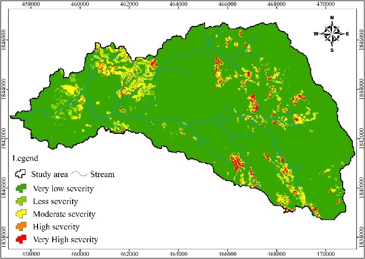
The Mae Tao watershed of Thailand faced cadmium (Cd) contamination problems from zinc mining for a long time until the mining area was closed to decrease the level of Cd concentration. This study reproduced the possible scenarios of Cd contamination due to soil loss. Four scenarios of forest restoration were implemented in this study, all of which were calculated with the Revised Universal Soil Loss Equation (RUSLE) integrated with satellite imagery and Geographic Information Systems (GIS). Landsat 8-OLI was acquired and land use/land cover (LULC) was classified in each scenario. Soil loss maps were created. An inverse distance weighting (IDW) technique was used to estimate the concentration of Cd based on the field data consisting of 101 points of measured Cd concentration. Results from RUSLE model and IDW technique were combined to calculate Cd contamination due to soil loss for all four scenarios. Results showed that the restoration of Scenario 3, forest restoration in old and new mining areas in cooperation with reservoir construction, helped decrease Cd contamination the most. The lowest level of Cd contamination from soil loss was found in this scenario by about 156 ha (total of Cd contamination by 165,924.32 ton/year).
Article Details
Published articles are under the copyright of the Environment and Natural Resources Journal effective when the article is accepted for publication thus granting Environment and Natural Resources Journal all rights for the work so that both parties may be protected from the consequences of unauthorized use. Partially or totally publication of an article elsewhere is possible only after the consent from the editors.
References
Atoma H, Suryabhagaven K, Balakrishnan M. Soil erosion assessment using RUSLE model and GIS in Huluka watershed, central Ethiopia. Sustainable Water Resources Management 2020;6:1-12.
Azpurua M, Ramos K. A comparison of spatial interpolation methods for estimation of average electromagnetic field magnitude. Progress in Electromagnetics Research 2020;14:135-45.
Batista G, Silva N, Silva C, Curi N, Bueno T, Junior A, et al. Modeling spatially distributed soil losses and sediment yield in the upper Grande River Basin-Brazil. Catena 2017;157:139-50.
Chuenchum P, Xu M, Tang W. Estimation of soil erosion and sediment yield in the Lancang-Mekong River using the modified revised universal soil loss equation and GIS techniques. Water 2020;12,135.
Department of Primary Industries and Mines (DPIM). Report of the Study on the Solution of Cd Contamination in the Mae Tao Basin, Mae Sot District, Tak Province. Bangkok, Thailand: Office of Primary Industries and Mines Khet3 (Northern part), Ministry of Industry; 2009a.
Department of Primary Industries and Mines (DPIM). Report of Water Quality and Stream Sediment Monitoring at Doi Padaeng zinc Mining in Mae Sot District, Tak Province. Bangkok, Thailand: Office of Primary Industries and Mines Khet3 (Northern part), Ministry of Industry; 2009b.
European Commission. Soil erosion risk assessment in Italy [Internet]. 2000 [cited 2020 Feb 24]. Available from: https://esdac.jrc.ec.europa.eu/ESDB_Archive/serae/GRIMM/italia/eritaly.pdf.
Farhan Y, Zregat D, Farhan I. Spatial estimation of soil erosion risk using RUSLE approach, RS, and GIS techniques: A case study of Kufranja watershed, Northern Jordan. Journal of Water Resource and Protection 2013;5:1247-61.
Ganasri P, Ramesh H. Assessment of soil erosion by RUSLE model using remote sensing and GIS-A case study of Nethravathi Basin. Geoscience Frontiers 2016;7:953-61.
Kassawmar T, Gessesse GD, Zeleke G, Subhatu A. Assessing the soil erosion control efficiency of land management practices implemented through free community labor mobilization in Ethiopia. International Soil and Water Conservation Research 2018;6:87-98.
Kim HS. Soil Erosion Modeling Using RUSLE and GIS on the IMHA Watershed, South Korea [dissertation]. USA: Colorado State University; 2006.
Land Development Department. Soil Loss in Thailand. Bangkok, Thailand: Ministry of Agriculture and Cooperatives; 2000.
Lazzari M, Gioia D, Piccarreta M, Daneses M, Lanorate A. Sediment yield and erosion rate estimation in the mountain catchments of the Camastra artificial reservoir (Southern Italy): A comparison between different empirical methods. Catena 2015;127:323-39.
Lee S, Lee H. Scaling effect for estimating soil loss in the RUSLE model using remotely sensed geospatial data in Korea. Journal of Hydrology and Earth System Science 2006;3:135-57.
Mesnard L. Pollution models and inverse distance weighting: Some critical remarks. Computer and Geosciences 2013;52:459-69.
Millward A, Mersey J. Adapting the RUSLE to model soil erosion potential in a mountainous tropical watershed. Catena 1999;38:109-29.
Oliveria S, Wendland E, Nearing A. Rainfall erosivity in Brazil: A review. Catena 2012;100:139-47.
Ostovari Y, Ghorbani-Dashtaki S, Bahrami H, Naderi M, Dematte A. Soil loss estimation using RUSLE model, GIS and remote sensing techniques: A case study from the Dembecha Watershed, Northwestern Ethiopia. Geoderma 2017;11:28-36.
Ozcan U, Erpul G, Basaran M, Erdogan E. Use of USLE/GIS technology integrated with geostatistics to assess soil erosion risk in different land uses of Indagi Mountain Pass-Cankırı, Turkey. Environment Geology 2007;53:1731-41.
Pollution Control Department (PCD). Annual Report 2013. Bangkok, Thailand: Ministry of Natural Resources and Environment; 2013.
Rammahi AH, Khassaf SI. Estimation of soil erodibility factor in RUSLE equation for Euphrates River watershed using GIS. International Journal of GEOMATE 2018;14:164-9.
Simmons RW, Pongsakul P. Towards the development of a sampling strategy to evaluate the spatial distribution of Cd in contaminated irrigated rice-based agricultural systems. Proceeding of the 17th World Congress of Soil Science; 2002 Aug 14-21; Bangkok: Thailand; 2002.
Simmons RW, Pongsakul P, Chaney RL, Saiyasipanich D, Klinphoklap S, Nobuntou W. The relative exclusion of zinc and iron from rice grain in relation to rice grain cadmium as compared to soybean: Implications for human health. Plant Soil 2003;257:163-70.
Simmons RW, Sukreeyaponge O, Noble AD, Chinabut N. Final Report of LDD-IWMI Land Zoning and Cd Risk Assessment Activities Undertaken in Phatat Pha Daeng and Mae Tao Mai Sub-district, Mae Sot, Tak Province, Thailand. SEA Regional Office, Kasetsart University, Thailand: International Water Management Institute; 2005.
Somprasong K, Chaiwiwatworakul P. Estimation of potential cadmium contamination using an integrated RUSLE, GIS and remote sensing technique in a remote watershed: A case study of the Mae Tao Basin, Thailand. Environmental Earth Sciences 2015;73:4805-18.
Sriprachote A, Kanyawongha P, Ochiai K, Matoh T. Current situation of cadmium-polluted paddy soil, rice and soybean in the Mae Sot District, Tak Province, Thailand. Soil Science and Plant Nutrition 2012;58:349-59.
Suppakarn T, Waragorn S, Pirat J. Application of vegetation and soil indices for monitoring the reclamation area at Phadeng zinc mine in Tak Province, Northern Thailand. Proceeding of the Asia-Pacific Conference on Engineering and Applied Science; 2016 Aug 25-27; Tokyo: Japan; 2016.
Thamjedsada T, Chaiwiwatworakul P. Evaluation of cadmium contamination in the Mae Tao Creek sediment. Proceeding of the 2012 International Conference on Sustainable Environmental Technologies (ICSET); 2012 Apr 26-27; Century Park Hotel, Bangkok: Thailand; 2012.
Unhalekhaka U, Kositanont C. Distribution of cadmium in soil around zinc mining area. Thai Journal of Toxicology 2008;23:170-4.
Xu L, Xu X, Meng X. Risk assessment of soil erosion in different rainfall scenarios by RUSLE model coupled with information diffusion model: A case study of Bohai Rim, China. Catena 2012;100:74-82.
