Landslide Risk Analysis on Agriculture Area in Pacitan Regency in East Java Indonesia Using Geospatial Techniques 10.32526/ennrj/19/2020167
Article Sidebar
Main Article Content
Abstract
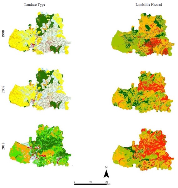
Pacitan is one of the regencies in East Java Province, dominated by hills and mountain landforms covering 85% of its area. Since 2011, more than 16 landslides have occurred significantly in this area. These disasters have engulfed more than 350 ha of agricultural land in Pacitan. This study analyzed the risk of future landslides due to land use change. The parameters used were rainfall, slope, topography, geology, soil, and land use which were assessed and weighed by the Paimin method. Land-use classification from Landsat 8 OLI in 1998, 2008, and 2018 were analyzed using regression formula to calculate the trend of change in 2030. Land use was also classified from the land capability classification (LCC) and regional spatial planning (RSP) as land use options in 2030. The results showed that land use changed over time due to the changes in landslide hazards, which increased three-foldfrom 1998 to 2018 and will peak tremendously in 2030. There are 29.47 ha of agricultural land in 2018 that have a high potential landslide hazard if no intervention is made. The accuracy for prediction of the 2018 data mapping was 82%. The LCC strategy suggests land use planning to reduce a high level of the landslides.
Article Details
Published articles are under the copyright of the Environment and Natural Resources Journal effective when the article is accepted for publication thus granting Environment and Natural Resources Journal all rights for the work so that both parties may be protected from the consequences of unauthorized use. Partially or totally publication of an article elsewhere is possible only after the consent from the editors.
References
Arif N, Projo D, Hatono H. Raster-based qualitative spatial erosion modeling (case study in das serang, kulonprogo district. Journal of Environmental Science 2017;15(2):127-34.
Arsyad S. Soil and Water Conservation. Bogor, Indonesia: Institut Pertanian Bogor Press; 1989.
Avridianto DF. Landslides risk level in ketro village, tulakan sub-district, Pacitan District. Swara Bhumi 2016;1(2):18-27.
Badan Nasional Penanggulangan Bencana (BNPB). Indonesian Disaster Information Data [Internet]. 2016 [cited 2020 Jul 21]. Available from: http://dibi.bnpb.go.id/.
Budiono UF. White Book of Pacitan District Sanitation Chapter I. Preliminary. Pacitan, Indonesia: Pacitan Distric Government. 2012.
Conforti M, Pascale S, Robustelli G, Sdao F. Evaluation of prediction capability of the artificial neural networks for mapping landslide susceptibility in the Turbolo River catchment (northern calabria, italy). Catena 2014;113(2-3):236-50.
Cruden DM. A simple definition of a landslides. Bulletin of the International Association of Engineering Geology 1991; 43(1):27-9.
Dagdelenler G, Nefeslioglu HA, Gokceoglu C. Modification of seed cell sampling strategy for landslide susceptibility mapping: An application from the eastern part of the gallipoli peninsula (canakkale, turkey). Bulletin of Engineering Geology and the Environment 2015;75(2):575-90.
Fan W, Wei X, Cao Y, Zheng B. Landslide susceptibility assessment using the certainty factor and analytic hierarchy process. Journal of Mountain Science 2017;14(5):906-25.
Faturahman BM. Strategy of emergency response of flood and landslide disaster in pacitan regency. Jurnal Ilmu Administrasi Media Pengembangan Ilmu dan Praktek Administrasi 2018;15(2):133-47.
Frounde MJ, Petley DN. Global fatal landslide occurrence 2004 to 2016. Natural Hazards and Earth System Sciences 2018;18:2161-81.
Glade T. Landslide occurrence as a response to land use change: A review of evidence from New Zealand. Catena 2003;51(3-4):297-314.
Haigh MJ, Rawat JS, Batarya SK, Rai SP. Interactions between forest and landslide activity along new highways in the kumaun himalaya. Forest Ecology and Management 1995;78(1-3):173-89.
Hidayah RA, Dzakiya N. Analysis geological and geophysical data for landslide prediction hazard zone with weight of evidence method in pacitan district east java. Journal of Applied Geospatial Information 2018;2(1):117-23.
Hidayat R, Sutanto SJ, Hidayah A, Ridwan B, Mulyana A. Development of a landslide early warning system in indonesia. Geosciences 2019;9(10):451.
Jakob M. The impacts of logging on landslide activity at clayoquot sound, british columbia. Catena 2000;38(4):279-300.
Jaya I. Landslide detection techniques using multi-time spot imagery, case studies in Teradomari, Tochio and Shidata Mura, Niigata, Japan. Journal of Tropical Forest Management 2005;10(1):31-48.
Jiao Y, Zhao D, Ding Y, Liu Y, Xu Q, Qiu Y, et al. Performance evaluation for four gis-based models purposed to predict and map landslide susceptibility: A case study at a world heritage site in southwest china. Catena 2019;183:104221.
Karsli F, Atasoy M, Yalcin A, Reis S. Effects of land-use changes on landslides in a landslide-prone area (ardesen, rize, ne turkey). Environmnet and Monitoring Assesment 2009;156(1-4):241-55.
Kingsburry PA. Preliminary Assessment of the Johnson Hill Landslide, Palliser Bay. Contract Report 94.205. North Island, New Zealand: Wellington Regional Council; 1994.
Kirschbaum D, Stanley T, Zhou Y. Spatial and temporal analysis of a global landslide catalog. Geomorphology 2015;294:4-15.
Mohd MH, Rahman MAA, Azman FNUZ, Jusoh A. Landslide susceptibility mapping at lebir and galas river basins after extreme flood event using weights of evidence. Journal of Sustanability Science and Management 2019;14(2):103-15.
Naryanto HS, Soewandita H, Ganesha D, Prawiradisastra F. Analysis of the causes of the occurrence and evaluation of landslides in Banaran Village, Pulung District, Ponorogo Regency, East Java Province. Journal of Environmental Science 2019;17(2):272-82.
Nita I, Putra AN, Fibrianingtyas A. Analysis of drought hazards in agricultural land in Pacitan Regency, Indonesia. Journal of Soil Science and Agroclimatology 2020;17(1):7-15.
Nohani E, Moharrami M, Sharafi S, Khosravi K, Pradhan B, Pham BT, et al. Landslide susceptibility mapping using different gis-based bivariate models. Water 2019;11(7):1402.
Nusantara YP, Setianto A. Landslide hazard mapping using the frequency ratio method in piyungan and pleret sub-districts, bantul district, yogyakarta special area. Proceedings of 8th Academia-industry Lingkage National Earth Seminar; 2015 Oct 15-16; Graha Sabha Permana, Yogyakarta: Indonesia; 2015.
Paimin, Pramono IB, Purwanto, Inrawati DR. Watershed Management Planning System. Jakarta, Indonesia: Ministry of Forestry, Forestry Research and Development Agency, Research and Development Center for Conservation and Rehabilitation; 2012.
Paimin, Sukresno, Pramono IB. Flood and Landslide Mitigation Techniques. Balikpapan, Indonesia: Tropenbos International Indonesia Programme; 2009.
Panagos P, Standardi G, Borrelli P, Lugato E, Montanarella L. Cost of agricultural productivity loss due to soil erosion in the European Union: From direct cost evaluation approaches to the use of macroeconomic models. Land Degradation and Development 2018;29:471-84.
Priyono KD. A study of clay mineral in the occurences of landslide disaster area at kulonprogo mountains yogyakarta special province. Geography Forum 2012;26(1):53-64.
Putra AN, Nita I. Reliability of using high-resolution aerial photography (red, green and blue bands) for detecting available soil water in agricultural land. Journal of Degraded Minning and Lands Management 2020;7(3):2221-32.
Samodra H, Gafoer S, Tjokrosapoetro S. Geological map sheet pacitan, java, scale 1: 100.000. Bandung, Indonesia: Geological Research and Development Center; 1992.
Setiadi T. Designing a geographic information system for mapping landslide prone areas, mitigation and disaster management in Banjarnegara District. Kes Mas 2013;7(1):33–43. (in Indonesian)
Sipayung SB, Cholianawati N, Susanti I, Aulia SR, Maryadi E. Development of empirical equation model in predicting the occurrence of landslide at watershed of citarum (west java) based on thetrmm satellite data. Journal of Sains Dirgantara 2014;12(1):12-21.
Solle MS, Ahmad A. Identification of soil, rock and tectovolcanisme on landslides intensity in tondano watershed. Journal of Geological Resource and Engineering 2016;6:271-82.
Sulistyo B. The role of geographic information systems in mitigating landslides. Proceedings of the National Seminar on Disaster Mitigation in Regional Development Planning; 2016 Mar 28; Agricultural Faculty, Bengkulu University, Bengkulu: Indonesia; 2016.
Susanti PD, Harjadi B, Miardini A. Vulnerability analysis as a basis for landslide mitigation in banjarnegara regency. Journal of Watershed Management Research 2017;1(1):49-59.
Wu W, Sidle RC. A distributed slope stability model for steep forested basins Water Resources Research 1995;31(8):2097-110.
Yasta RD, Yarmaidi Y. Analysis of changes in the use of paddy fields to settlements in the north pagelaran district. Journal of Geographic Research 2019;7(3):1-11.
Zhao L, Zuo S, Deng D, Han Z, Zhao B. Development mechanism for the landslide at xinlu Village, Chongqing, China. Landslides 2018;15:2075-081.
