Spatial Zonation of Landslide Prone Area Using Information Value in the Geologically Fragile Region of Samdrup Jongkhar-Tashigang National Highway in Bhutan 10.32526/ennrj/19/2020171
Article Sidebar
Main Article Content
Abstract
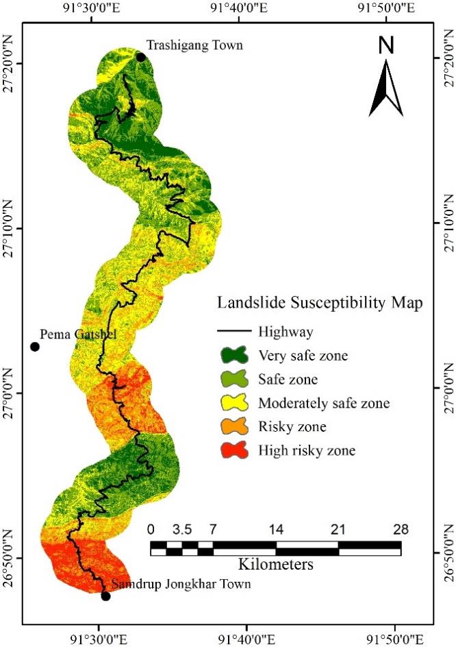
Samdrup Jongkhar-Tashigang National Highway (SJ-TG NH) in Bhutan experiences several landslides every year. However, there are no studies on the landslides which will assist in highway realignment. This study developed the landslide susceptibility mapping (LSM) using the information value (IV) and check the reliability of the IV. The workflow consists of landslide inventory, factor preparation, LSM development, and its validation. During the landslide inventory, a total of 130 landslides were identified from satellite image interpretation, google earth image, and field investigation. The landslide inventory was divided into a training dataset (70%) and a validation dataset (30%). Then, nine factors were used to construct a spatial database. The accuracy was conducted using the area under curve (AUC) and the reliability of the model was performed using the kappa index. The AUC for the success rate (0.7700) falls under a good category and the prediction rate (0.6798) falls under the moderate category. The kappa index (0.3407) for the IV falls under the fair reliability category. The LSM was classified into very safe (16.42%), safe (30.64%), moderately (27.67%), risky (16.18%), and high risky zones (9.09%) based on the natural break. The LSM will guide decision-makers in the realignment of the road.
Article Details
Published articles are under the copyright of the Environment and Natural Resources Journal effective when the article is accepted for publication thus granting Environment and Natural Resources Journal all rights for the work so that both parties may be protected from the consequences of unauthorized use. Partially or totally publication of an article elsewhere is possible only after the consent from the editors.
References
Achour Y, Boumezbeur A, Hadji R, Chouabbi A, Cavaleiro V, Bendaoud EA. Landslide susceptibility mapping using analytic hierarchy process and information value methods along a highway road section in Constantine, Algeria. Arabian Journal of Geosciences 2017;10(8):194.
Aleotti P, Chowdhury R. Landslide hazard assessment: Summary review and new perspectives. Bulletin of Engineering Geology and the Environment 1999;58(1):21-44.
Ba Q, Chen Y, Deng S, Wu Q, Yang J, Zhang J. An improved information value model based on gray clustering for landslide susceptibility mapping. ISPRS International Journal of Geo-Information 2017;6(1):18.
Chauhan S, Sharma M, Arora MK. Landslide susceptibility zonation of the Chamoli Region, Garhwal Himalayas, using logistic regression model. Landslides 2010;7(4):411-23.
Chen W, Li W, Hou E, Zhao Z, Deng N, Bai H, et al. Landslide susceptibility mapping based on GIS and information value model for the Chencang District of Baoji, China. Arabian Journal of Geosciences 2014;7(11):4499-511.
Chuanhua Z, Xueping W. Landslide susceptibility mapping: A comparison of information and weights-of-evidence methods in Three Gorges Area. Proceeding of the International Conference on Environmental Science and Information Application Technology; 2009 July 4-5; Wuhan: China; 2009.
Dilley M, Chen RS, Deichmann U, Lerner-Lam AL, Arnold M. Natural Disaster Hotspots: A Global Risk Analysis. The World Bank; 2005.
Geertsema M, Highland L, Vaugeouis L. Environmental Impact of landslides. Landslides-Disaster Risk Reduction: Springer; 2009. p. 589-607.
Jaafari A, Najafi A, Pourghasemi H, Rezaeian J, Sattarian A. GIS-based frequency ratio and index of entropy models for landslide susceptibility assessment in the Caspian forest, Northern Iran. International Journal of Environmental Science and Technology 2014;11(4):909-26.
Kahlon S, Chandel VB, Brar KK. Landslides in Himalayan Mountains: A study of Himachal Pradesh, India. International Journal of IT, Engineering and Applied Sciences Research 2014;3:28-34.
Kanungo D, Arora M, Gupta R, Sarkar S. Landslide risk assessment using concepts of danger pixels and fuzzy set theory in Darjeeling Himalayas. Landslides 2008;5(4):407-16.
Keunza K, Dorji Y, Wangda D. Landslides in Bhutan. Country Report. Thimpu. Bhutan: Department of Geology and Mines, Royal Government of Bhutan; 2004. p. 8.
Landis JR, Koch GG. The measurement of observer agreement for categorical data. Biometrics 1977:159-74.
Lei Z, Jingfeng H. GIS-based logistic regression method for landslide susceptibility mapping in regional scale. Journal of Zhejiang University-Science A 2006;7(12):2007-17.
Long S, McQuarrie N, Tobgay T, Grujic D, Hollister L. Geologic map of Bhutan. Journal of Maps 2011;7(1):184-92.
Mandal S, Mandal K. Bivariate statistical index for landslide susceptibility mapping in the Rorachu River Basin of Eastern Sikkim Himalaya, India. Spatial Information Research 2018;26(1):59-75.
Saha AK, Gupta RP, Sarkar I, Arora MK, Csaplovics E. An approach for GIS-based statistical landslide susceptibility zonation-with a case study in the Himalayas. Landslides 2005;2(1):61-9.
Shirani K, Pasandi M, Arabameri A. Landslide susceptibility assessment by dempster-shafer and index of entropy models, Sarkhoun Basin, Southwestern Iran. Natural Hazards 2018;93(3):1379-418.
Shirzadi A, Bui DT, Pham BT, Solaimani K, Chapi K, Kavian A, et al. Shallow landslide susceptibility assessment using a novel hybrid intelligence approach. Environmental Earth Sciences 2017;76(2):60.
Singh K, Kumar V. Hazard assessment of landslide disaster using information value method and analytical hierarchy process in highly tectonic Chamba Region in bosom of Himalaya. Journal of Mountain Science 2018;15(4):808-24.
Tien Bui D, Shahabi H, Omidvar E, Shirzadi A, Geertsema M, Clague JJ, et al. Shallow landslide prediction using a novel hybrid functional machine learning algorithm. Remote Sensing 2019;11(8):931.
Toshiro O. Classification Methods for Spatial Data Representation. London, UK: Center for Advanced Spatial Analysis University College London; 2002.
Yin K, Yan, T. Statistical prediction model for slope instability of metamorphosed rock. Proceedings of the 5th International Symposium on Landslides; 1988 Jul 10; Lausanne: Switserland; 1988. p. 1269-72.
