Assessing and Simulating Impacts of Land Use Land Cover Changes on Land Surface Temperature in Mymensingh City, Bangladesh 10.32526/ennrj/20/202100110
Article Sidebar
Main Article Content
Abstract
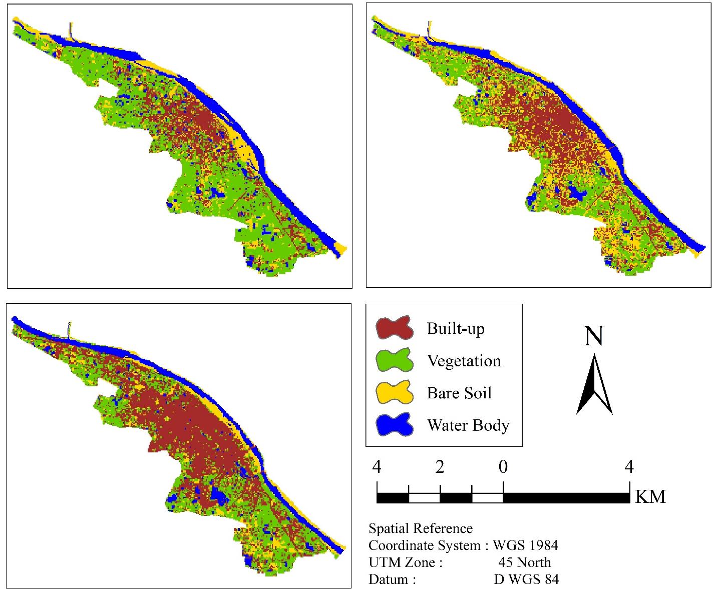
Urban developments in the cities of Bangladesh are causing the depletion of natural land covers over the past several decades. One of the significant implications of the developments is a change in Land Surface Temperature (LST). Through LST distribution in different Land Use Land Cover (LULC) and a statistical association among LST and biophysical indices, i.e., Urban Index (UI), Bare Soil Index (BI), Normalized Difference Builtup Index (NDBI), Normalized Difference Bareness Index (NDBaI), Normalized Difference Vegetation Index (NDVI), and Modified Normalized Difference Water Index (MNDWI), this paper studied the implications of LULC change on the LST in Mymensingh city. Landsat TM and OLI/TIRS satellite images were used to study LULC through the maximum likelihood classification method and LSTs for 1989, 2004, and 2019. The accuracy of LULC classifications was 84.50, 89.50, and 91.00 for three sampling years, respectively. From 1989 to 2019, the area and average LST of the built-up category has been increased by 24.99% and 7.6ºC, respectively. Compared to vegetation and water bodies, built-up and barren soil regions have a greater LST each year. A different machine learning method was applied to simulate LULC and LST in 2034. A remarkable change in both LULC and LST was found through this simulation. If the current changing rate of LULC continues, the built-up area will be 59.42% of the total area, and LST will be 30.05ºC on average in 2034. The LST in 2034 will be more than 29ºC and 31ºC in 59.64% and 23.55% areas of the city, respectively.
Article Details

This work is licensed under a Creative Commons Attribution-NonCommercial 4.0 International License.
Published articles are under the copyright of the Environment and Natural Resources Journal effective when the article is accepted for publication thus granting Environment and Natural Resources Journal all rights for the work so that both parties may be protected from the consequences of unauthorized use. Partially or totally publication of an article elsewhere is possible only after the consent from the editors.
References
Ahmed B, Ahmed R. Modeling urban land cover growth dynamics using multi-temporal satellite images: A case study of Dhaka, Bangladesh. ISPRS International Journal of Geo-Information 2012;1(1):3-31.
Ahmed B, Kamruzzaman MD, Zhu X, Rahman M, Choi K. Simulating land cover changes and their impacts on land surface temperature in Dhaka, Bangladesh. Remote Sensing 2013;5(11):5969-98.
Alam MK, Hasan AK, Khan MR, Whitney JW. Geological Map of Bangladesh [Internet]. 1990 [cited 2020 Mar 3]. Availabe from: https://pubs.usgs.gov/of/1997/ofr-97-470/OF97-470H/ ofr97470H_geo.pdf.
Alam MS, Haque SM. Assessment of urban physical seismic vulnerability using the combination of AHP and TOPSIS models: A case study of residential neighborhoods of Mymensingh city, Bangladesh. Journal of Geoscience and Environment Protection 2018;6(2):165-83.
Al-sharif AA, Pradhan B. Monitoring and predicting land use change in Tripoli Metropolitan City using an integrated Markov chain and cellular automata models in GIS. Arabian Journal of Geosciences 2014;7(10):4291-301.
Anderson JR, Hardy EE, Roach JT, Witmer RE. A Land Use and Land Cover Classification System for Use with Remote Sensor Data. USGS Professional Paper 964. Sioux Falls, USA: United States Geological Survey; 1976.
Artis DA, Carnahan WH. Survey of emissivity variability in thermography of urban areas. Remote Sensing of Environment 1982;12(4):313-29.
Avdan U, Jovanovska G. Algorithm for automated mapping of land surface temperature using LANDSAT 8 satellite data. Journal of Sensors 2016;2016:Article No. 1480307.
Bahi H, Rhinane H, Bensalmia A, Fehrenbach U, Scherer D. Effects of urbanization and seasonal cycle on the surface urban heat island patterns in the coastal growing cities: A case study of Casablanca, Morocco. Remote Sensing 2016;8(10): Article No. 829.
Bangladesh Bureau of Statistics (BBS). Population and Housing Census 2011. Dhaka, Bangladesh: Ministry of Planning, Govt. of Bangladesh [Internet]. 2011 [cited 2020 Mar 3]. Available from: http://www.bbs.gov.bd/site/page/47856ad0-7e1c-4aab-bd78-892733bc06eb/Population-and-Housing-Census.
Bangladesh Meteorological Department (BMD). Climate Data Library [Internet]. 2019 [cited 2020 Mar 3]. Available from: http://datalibrary.bmd.gov.bd/maproom/Climatology /index.html.
Bangladesh Planning Commission. Bangladesh Delta Plan 2100. Dhaka, Bangladesh: Ministry of Planning, Govt. of Bangladesh [Internet]. 2017 [cited 2020 Apr 17]. Available from:http://www.plancomm.gov.bd/site/files/0adcee77-2db8-41bf-b36b-657b5ee1efb9/Bangladesh-Delta-Plan-2100.
Bokaie M, Zarkesh MK, Arasteh PD, Hosseini A. Assessment of urban heat island based on the relationship between land surface temperature and land use/land cover in Tehran. Sustainable Cities and Society 2016;23:94-104.
Bonafoni S, Anniballe R, Gioli B, Toscano P. Downscaling Landsat land surface temperature over the urban area of Florence. European Journal of Remote Sensing 2016;49(1):553-69.
Brammer H. Physical Geography of Bangladesh. Dhaka, Bangladesh: The University Press Ltd.; 2012.
Brammer H. The Geography of the Soils of Bangladesh. Dhaka, Bangladesh: The University Press Ltd.; 1996.
Butler K. Band Combinations for Landsat 8 [Internet]. 2013 [cited 2020 Feb 17]. Available from: https://blogs.esri.com /esri/arcgis/2013/07/24/band-combinations-for-landsat-8/.
Chander G, Markham B. Revised Landsat-5 TM radiometric calibration procedures and postcalibration dynamic ranges. IEEE Transactions on Geoscience and Remote Sensing 2003;41(11):2674-7.
Chander G, Markham BL, Helder DL. Summary of current radiometric calibration coefficients for Landsat MSS, TM, ETM+, and EO-1 ALI sensors. Remote Sensing of Environment 2009;113(5):893-903.
Chen XL, Zhao HM, Li PX, Yin ZY. Remote sensing image-based analysis of the relationship between urban heat island and land use/cover changes. Remote Sensing of Environment 2006;104(2):133-46.
Corner RJ, Dewan AM, Chakma S. Monitoring and prediction of land-use and land-cover (LULC) change. In: Dewan AM, Corner RJ, editors. Dhaka Megacity. Dordrecht, Netherlands: Springer; 2014. p. 75-97.
Dereczynski CP, Luiz Silva W, Marengo JA. Detection and projections of climate change in Rio de Janeiro, Brazil. American Journal of Climate Change 2013;2:25-33.
Dewan AM, Corner RJ. Impact of land use and land cover changes on urban land surface temperature. In: Dewan AM, Corner RJ, editors. Dhaka Megacity. Dordrecht, Netherlands: Springer; 2014a. p. 219-38.
Dewan AM, Corner RJ. Spatiotemporal analysis of urban growth, sprawl and structure. In: Dewan AM, Corner RJ, editors. Dhaka Megacity. Dordrecht, Netherlands: Springer; 2014b. p. 99-121.
Erener A. Classification method, spectral diversity, band combination and accuracy assessment evaluation for urban feature detection. International Journal of Applied Earth Observation and Geoinformation 2013;21:397-408.
Gazi MY, Rahman MZ, Uddin MM, Rahman FA. Spatio-temporal dynamic land cover changes and their impacts on the urban thermal environment in the Chittagong metropolitan area, Bangladesh. GeoJournal 2020;24:1-6.
Grimmond SU. Urbanization and global environmental change: Local effects of urban warming. Geographical Journal 2007;173(1):83-8.
Guha S, Govil H, Diwan P. Analytical study of seasonal variability in land surface temperature with normalized difference vegetation index, normalized difference water index, normalized difference built-up index, and normalized multiband drought index. Journal of Applied Remote Sensing 2019;13(2):Article No. 024518.
Han-Qiu XU. A study on information extraction of water body with the modified normalized difference water index (MNDWI). Journal of Remote Sensing 2005;5:589-95.
Hasan SS, Deng X, Li Z, Chen D. Projections of future land use in Bangladesh under the background of baseline, ecological protection and economic development. Sustainability 2017;9(4):Article No. 505.
Huete A, Didan K, van Leeuwen W, Miura T, Glenn E. MODIS vegetation indices. In: Ramachandran B, Justice CO, Abrams MJ, editors. Land Remote Sensing and Global Environmental Change. New York, USA: Springer; 2010. p. 579-602.
Intergovernmental Panel on Climate Change (IPCC). Climate Change 2014: Mitigation of Climate Change. In: Contribution of Working Group III to the Fifth Assessment Report of the Intergovernmental Panel on Climate Change. New York, USA: Cambridge University Press; 2014.
Jiménez-Muñoz JC, Sobrino JA, Skoković D, Mattar C, Cristóbal J. Land surface temperature retrieval methods from Landsat-8 thermal infrared sensor data. IEEE Geoscience and Remote Sensing Letters 2014;11(10):1840-3.
Kabir A. Mymensingh Strategic Development 2011-2035 [Internet]. 2015 [cited 2020 Mar 10]. Available from: http://msdp.gov.bd/reports/category/13.
Kafy AA, Rahman MS, Hasan MM, Islam M. Modelling future land use land cover changes and their impacts on land surface temperatures in Rajshahi, Bangladesh. Remote Sensing Applications: Society and Environment 2020;18:Article No. 100314.
Kayet N, Pathak K, Chakrabarty A, Sahoo S. Urban heat island explored by co-relationship between land surface temperature vs multiple vegetation indices. Spatial Information Research 2016;24(5):515-29.
Kikon N, Singh P, Singh SK, Vyas A. Assessment of urban heat islands (UHI) of Noida City, India using multi-temporal satellite data. Sustainable Cities and Society 2016;22:19-28.
Lai LW, Cheng WL. Urban heat island and air pollution: An emerging role for hospital respiratory admissions in an urban area. Journal of Environmental Health 2010;72(6):32-6.
Li YY, Zhang H, Kainz W. Monitoring patterns of urban heat islands of the fast-growing Shanghai metropolis, China: Using time-series of Landsat TM/ETM+ data. International Journal of Applied Earth Observation and Geoinformation 2012; 19:127-38.
Li ZL, Tang BH, Wu H, Ren H, Yan G, Wan Z, et al. Satellite-derived land surface temperature: Current status and perspectives. Remote Sensing of Environment 2013;131:14-37.
Maduako ID, Yun Z, Patrick B. Simulation and prediction of land surface temperature (LST) dynamics within Ikom City in Nigeria using artificial neural network (ANN). Journal of Remote Sensing and GIS 2016;5(1):1-7.
Maimaitiyiming M, Ghulam A, Tiyip T, Pla F, Latorre-Carmona P, Halik Ü, et al. Effects of green space spatial pattern on land surface temperature: Implications for sustainable urban planning and climate change adaptation. ISPRS Journal of Photogrammetry and Remote Sensing 2014;89:59-66.
Markham BL, Barker JL. Spectral characterization of the Landsat Thematic Mapper sensors. International Journal of Remote Sensing 1985;6(5):697-716.
McCarthy MP, Best MJ, Betts RA. Climate change in cities due to global warming and urban effects. Geophysical Research Letters 2010;37(9):Article No. L09705.
Mishra VN, Rai PK, Prasad R, Punia M, Nistor MM. Prediction of spatio-temporal land use/land cover dynamics in rapidly developing Varanasi District of Uttar Pradesh, India, using geospatial approach: A comparison of hybrid models. Applied Geomatics 2018;10(3):257-76.
Mishra VN, Rai PK. A remote sensing aided multi-layer perceptron-Markov chain analysis for land use and land cover change prediction in Patna District (Bihar), India. Arabian Journal of Geosciences 2016;9(4):Article No. 249.
National Aeronautics and Space Administration (NASA). NASA’s Atmospheric Correction Parameter Calculator [Internet]. 2019 [cited 2020 Feb 17]. Available from: http://atmcorr.gsfc.nasa.gov/.
Pal S, Ziaul SK. Detection of land use and land cover change and land surface temperature in English Bazar urban centre. Egyptian Journal of Remote Sensing and Space Science 2017;20(1):125-45.
Qin Z, Karnieli A, Berliner P. A mono-window algorithm for retrieving land surface temperature from Landsat TM data and its application to the Israel-Egypt border region. International Journal of Remote Sensing 2001;22(18):3719-46.
Rahman MT, Aldosary AS, Mortoja M. Modeling future land cover changes and their effects on the land surface temperatures in the Saudi Arabian eastern coastal city of Dammam. Land 2017;6(2):Article No. 36.
Rashid KJ, Hoque MA, Esha TA, Rahman MA, Paul A. Spatiotemporal changes of vegetation and land surface temperature in the refugee camps and its surrounding areas of Bangladesh after the Rohingya influx from Myanmar. Environment, Development and Sustainability 2021; 23(3):3562-77.
Rosa W. Goal 11: Make cities and human settlements inclusive, safe, resilient, and sustainable. In: Rosa W, editor. A New Era in Global Health: Nursing and the United Nations 2030 Agenda for Sustainable Development. New York, USA: Springer Publishing Company; 2017. p. 339-44.
Rouf MA, Jahan S. Spatial and Temporal Patterns of Urbanization in Bangladesh. Urbanization in Bangladesh: Patterns, Issues and Approaches to Planning. Dhaka, Bangladesh: Bangladesh Institute of Planners; 2007. p. 1-24.
Roy DP, Wulder MA, Loveland TR, Woodcock CE, Allen RG, Anderson MC, et al. Landsat-8: Science and product vision for terrestrial global change research. Remote Sensing of Environment 2014;145:154-72.
Roy PS, Miyatake S, Rikimaru A. Biophysical spectral response modeling approach for forest density stratification. Proceedings of the 18th Asian Conference on Remote Sensing; 1997 Oct 20-24; Kuala Lumpur: Malaysia; 1997.
Roy S, Farzana K, Papia M, Hasan M. Monitoring and prediction of land use/land cover change using the integration of Markov chain model and cellular automation in the Southeastern Tertiary Hilly Area of Bangladesh. International Journal of Sciences: Basic and Applied Research 2015;24:125-48.
Roy S, Mahmood R. Monitoring shoreline dynamics using Landsat and hydrological data: A case study of Sandwip Island of Bangladesh. Pennsylvania Geographer 2016;54(2):20-41.
Roy S, Pandit S, Eva EA, Bagmar MS, Papia M, Banik L, et al. Examining the nexus between land surface temperature and urban growth in Chattogram Metropolitan Area of Bangladesh using long term Landsat series data. Urban Climate 2020;32:Article No. 100593.
Salisbury JW, D’Aria DM. Emissivity of terrestrial materials in the 3-5 μm atmospheric window. Remote Sensing of Environment 1994;47(3):345-61.
Scarano M, Sobrino JA. On the relationship between the sky view factor and the land surface temperature derived by Landsat-8 images in Bari, Italy. International Journal of Remote Sensing 2015;36(19-20):4820-35.
Sobrino JA, Jiménez-Muñoz JC, Paolini L. Land surface temperature retrieval from LANDSAT TM 5. Remote Sensing of Environment 2004;90(4):434-40.
Sobrino JA, Raissouni N. Toward remote sensing methods for land cover dynamic monitoring: Application to Morocco. International Journal of Remote Sensing 2000;21(2):353-66.
Solecki WD, Rosenzweig C, Parshall L, Pope G, Clark M, Cox J, et al. Mitigation of the heat island effect in urban New Jersey. Global Environmental Change Part B: Environmental Hazards 2005;6(1):39-49.
Trenberth KE. Rural land-use change and climate. Nature 2004;427(6971):Article No. 213.
Ullah S, Tahir AA, Akbar TA, Hassan QK, Dewan A, Khan AJ, et al. Remote sensing-based quantification of the relationships between land use land cover changes and surface temperature over the Lower Himalayan Region. Sustainability 2019; 11(19):Article No. 5492.
United Nations (UN). World Population Prospects 2019: Highlights. Department of Economic and Social Affairs [Internet]. 2019 [cited 2020 Mar 10]. Available from: https://www.un.org/development/desa/publications/world-population-prospects-2019-highlights.html.
United Nations (UN). World Population Prospects: The 2017 Revision, Key Findings and Advance Tables. New York, USA: The United Nations; 2017.
United Nations Human Settlement Programme (UNHABITAT). Urbanization and Development: Emerging Futures. World cities report. Nairobi, Kenya: United Nations Human Sttlements Programme; 2016.
United States Geological Survey (USGS). Changes to Thermal Infrared Sensor (TIRS) data. Landsat 8 OLI and TIRS Calibration Notices [Internet]. 2014 [cited 2020 Feb 5]. Available from: https://www.usgs.gov/land-resources/nli/ landsat/landsat-8-oli-and-tirs-calibration-notices.
United States Geological Survey (USGS). Landsat 7 (L7) Data Users Handbook. South Dakota, USA: Earth Resources Observation and Science (EROS); 2019.
Van de Griend AA, OWE M. On the relationship between thermal emissivity and the normalized difference vegetation index for natural surfaces. International Journal of Remote Sensing 1993;14(6):1119-31.
Vani M, Prasad PR. Assessment of spatio-temporal changes in land use and land cover, urban sprawl, and land surface temperature in and around Vijayawada city, India. Environment, Development and Sustainability 2020; 22(4):3079-95.
Veronez MR, Thum AB, Luz AS, Da Silva DR. Artificial neural networks applied in the determination of soil surface temperature-SST. Proceedings of the 7th International Symposium on Spatial Accuracy Assessment in Natural Resources and Environmental Sciences; 2006 Jul 5-7; Portugal, New University of Lisbon: 2006. p. 889-98.
Voogt JA, Oke TR. Thermal remote sensing of urban climates. Remote Sensing of Environment 2003;86(3):370-84.
Weng Q. A remote sensing? GIS evaluation of urban expansion and its impact on surface temperature in the Zhujiang Delta, China. International Journal of Remote Sensing 2001; 22(10):1999-2014.
World Bank. World Bank staff estimates based on the United Nations Population Division’s World Urbanization Prospects [Internet]. 2018 [cited 2020 Mar 10]. https://data.worldbank.org/indicator/sp.urb.totl.in.zs.
Xu H, Ding F, Wen X. Urban expansion and heat island dynamics in the Quanzhou region, China. IEEE Journal of Selected Topics in Applied Earth Observations and Remote Sensing 2009;2(2):74-9.
Yu X, Guo X, Wu Z. Land surface temperature retrieval from Landsat 8 TIRS: Comparison between radiative transfer equation-based method, split window algorithm and single channel method. Remote Sensing 2014;6(10):9829-52.
Zanter K. Landsat 8 (L8) Data Users Handbook Survey [Internet]. 2015 [cited 2020 Mar 10]. Available from: https://www.usgs.gov/core-science-systems/nli/landsat/landsat-8-data-users-handbook.
Zareie S, Khosravi H, Nasiri A, Dastorani M. Using Landsat Thematic Mapper (TM) sensor to detect change in land surface temperature in relation to land use change in Yazd, Iran. Solid Earth 2016;7(6):1551-64.
Zha Y, Gao J, Ni S. Use of normalized difference built-up index in automatically mapping urban areas from TM imagery. International Journal of Remote Sensing 2003;24(3):583-94.
Zhang F, Tiyip T, Kung H, Johnson VC, Maimaitiyiming M, Zhou M, et al. Dynamics of land surface temperature (LST) in response to land use and land cover (LULC) changes in the Weigan and Kuqa River oasis, Xinjiang, China. Arabian Journal of Geosciences 2016;9(7):1-4.
