Investigation on Impact of Changes in Land Cover Patterns on Surface Runoff in Ayung Watershed, Bali, Indonesia Using Geographic Information System 10.32526/ennrj/20/202100161
Article Sidebar
Main Article Content
Abstract
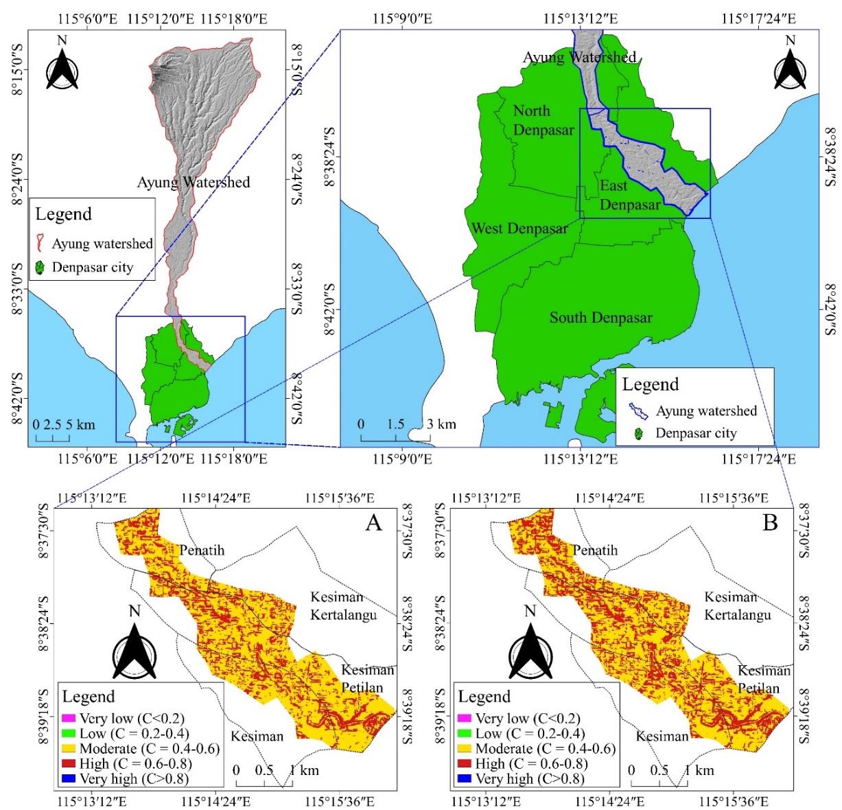
Population growth, urbanization, and infrastructure development activities have resulted in the land conversion of forests and farmlands to residential and commercial zones. Such land conversion causes changes in the land cover, as experienced in the Ayung Watershed, in the island of Bali, Indonesia. Here, the land cover undergoes rapid changes due to the growing tourism sector, affecting the runoff coefficient. This study evaluated the changing land cover patterns and surface runoff in the Ayung Watershed between 2012 and 2019. An increase in the surface runoff during the high rainfall events may lead to flooding in the area. The identification of land change patterns in the Ayung Watershed was carried out by a manual digitizing process on Google Earth maps. The runoff coefficient was calculated by Cook’s method using the four physical characteristics of the watershed: land cover, infiltration rate, land slope and drainage density; showing significant changes in the land cover in the study area. Farmlands and forests were reduced by 647.8 ha and 553.1 ha respectively, converted into fast growing grasslands or unproductive land. Such land cover changes have a negative impact by increasing the runoff coefficient in the area. During the study period, the runoff coefficient was consistently found to be more than 0.6 (high-risk category). Several sections in the city of Denpasar experienced an increase in the runoff coefficient by more than 5%. Consequently, there was a high-risk of flooding in the area because of the increasing surface runoff.
Article Details

This work is licensed under a Creative Commons Attribution-NonCommercial 4.0 International License.
Published articles are under the copyright of the Environment and Natural Resources Journal effective when the article is accepted for publication thus granting Environment and Natural Resources Journal all rights for the work so that both parties may be protected from the consequences of unauthorized use. Partially or totally publication of an article elsewhere is possible only after the consent from the editors.
References
Abdelaty EFS. Land use change detection and prediction using high spatial resolution Google Earth imagery and GIS techniques: A study on El-Beheira Governorate, Egypt. Proceedings of Fourth International Conference on Remote Sensing and Geoinformation of the Environment (RSCy2016); 2016 Apr 4-8; Paphos: Cyprus; 2016.
Adnyawati IAA. Land conversion Versus Subak: How Bali’s face gradually changing throughout history. Bali Tourism Journal 2019;3(1):38-42.
Amatya D, Callahan T, Hansen W, Trettin C, Radecki-Pawlik A, Meire P. Turkey Creek: A case study of ecohydrology and integrated watershed management in the low-gradient Atlantic Coastal Plain, USA. Journal of Water Resource and Protection 2015;07(10):792-814.
Aponte AGP. Runoff coefficients using a quickbird image for mapping flood hazard in a Tropical Coastal City, Campeche, Mexico. Proceedings of the IEEE International Geoscience and Remote Sensing Symposium; 2007 Jul 23-27; Barcelona: Spain; 2007.
Asare-Kyei D, Forkuor G, Venus V. Modeling flood hazard zones at the sub-district level with the rational model integrated with GIS and remote sensing approaches. Water 2015;7(7):3531-64.
As-syakur AR. Land use changes in Bali Province. Ecotropic: Journal of Environmental Science 2011;6(1):1-7 (in Indonesian).
Atharinafi Z, Wijaya N. Land use change and its impacts on surface runoff in rural areas of the upper Citarum Watershed (Case study: Cirasea sub-watershed). Journal of Regional and City Planning 2021;32(1):36-55.
Auliyani D, Nugrahanto EB. Peak discharge in Jemelak Subwatershed, Sintang District. Jurnal Sylva Lestari 2020;8(3):273-82 (in Indonesian).
Ayele GT, Tebeje AK, Demissie SS, Belete MA, Jemberrie MA, Teshome WM, et al. Time series land cover mapping and change detection analysis using geographic information system and remote sensing, Northern Ethiopia. Air, Soil and Water Research 2018;11:1-18.
Bellamy PW, Cho HJ. A GIS-based approach for determining potential runoff coefficient and runoff depth for the Indian River Lagoon, Florida, USA. In: Lagoon Environments around the World-A Scientific Perspective. London: IntechOpen; 2019. p. 1-24.
Berkarya B. Flash flood on upstream Ayung River, Denpasar local water company stops its production until December 25, 2016 [Internet]. 2016 [cited 2021 Jun 5]. Available from: https://www.baliberkarya.com/read/201612220016/banjir-bandang-di-hulu-sungai-ayung-pdam-denpasar-stop-produksi-hingga-25-desember (in Indonesian).
Blackwell PR, Wells G. DEM resolution and improved surface representation. Proceedings of the 19th Annual ESRI International User Conference; 1999 Jul 26-30; San Diego: California; 1999.
Badan Pusat Statistik (BPS). Number of foreign visitor to Bali dan Indonesia, 1969-2020: Indonesian statistics agency [Internet]. 2021a [cited 2021 Jul 21]. Available from: https://bali.bps.go.id/statictable/2018/02/09/28/jumlah-wisatawan-asing-ke-bali-dan-indonesia-1969-2019.html (in Indonesian).
Badan Pusat Statistik (BPS). Population projection of Bali Province by Gender: Indonesian statistics agency Bali Province [Internet]. 2021b [cited 2021 Jul 21]. Available from: https://bali.bps.go.id/indicator/12/28/1/proyeksi-penduduk-provinsi-bali-menurut-jenis-kelamin.html (in Indonesian).
Cunningham MA. Accuracy assessment of digitized and classified land cover data for wildlife habitat. Landscape and Urban Planning 2006;78(3):217-28.
Dadson IY. Land use and land cover change analysis along the coastal regions of Cape Coast and Sekondi. Ghana Journal of Geography 2016;8(2):108-26.
Darna IM. Due to flooding, Ayung River is Muddy, Badung Local Water Company Services Disrupted [Internet]. 2020 [cited 2021 Jul 5]. Available from: https://balitribune.co.id/ content/akibat-banjir-sungai-ayung-keruh-layanan-pdam-badung-terganggu (in Indonesian).
Dharma IG, Infantri Yekti M, Indra Permana G. The effect of land use changes on flood discharge. Berkala Ilimiah Teknik Keairan 2007;13(3):1-16 (in Indonesian).
Dickinson R. Runoff coefficient in InfoSewer and InfoSWMM [Internet]. 2017 [cited 2021 Oct 17]. Available from: https://swmm5.org/2017/11/06/runoff-coefficient-in-infosewer-and-infoswmm/.
Directory BT. Bali tourism: Tourism statistics: Bali tourism directory [Internet]. 2020 [cited 2021 Oct 20]. Available from: https://www.balitourismdirectory.com/tourism-studies/bali-tourism-statistics.html.
Duhita ADP, Rahardjo AP, Hairani A. The effect of slope on the infiltration capacity and erosion of Mount Merapi Slope Materials. Journal of the Civil Engineering Forum 2020;7(1):71-84.
El-Ashmawy KLA. Investigation of the accuracy of google earth elevation data. Artificial Satellites 2016;51(3):89-97.
Hua AK. Land use land cover changes in detection of water quality: A study based on remote sensing and multivariate statistics. Journal of Environmental and Public Health 2017;2017:1-12.
Indriatmoko RH, Wibowo VE. Geographic information system application for calculating the runoff coefficient of the Ciliwung Watershed. Jurnal Air Indonesia 2007;3(2):182-90 (in Indonesian).
Iswandi U, Widiatmaka, Pramudya B, Barus B. Delineation of flood hazard zones by using a multi criteria evaluation approach in Padang West Sumatera Indonesia. Journal of Environment and Earth Science 2016;6(3):205-14.
Kusmiyarti TB, Wiguna PPK, Dewi NR. Flood risk analysis in Denpasar City, Bali, Indonesia. Proceedings of the IOP Conference Series: the 2nd Geoplanning - International Conference on Geomatics and Planning; 2017 Aug 9-10; Surakarta: Indonesia; 2017.
Lanya I, Dibia IN, Diara IW, Suarjaya DG. Analysis of Subak landuse change due to tourism accomodation development in North Kuta Sub-district, Badung Regency, Indonesia. Proceedings of the IOP Conference Series: The 5th Geoinformation Science Symposium 2017 (GSS 2017); 2017 Sep 27-28; Yogyakarta: Indonesia; 2017.
Lemma TM, Gessesse GD, Kassa AK, Edossa DC. Effect of spatial scale on runoff coefficient: Evidence from the Ethiopian highlands. International Soil and Water Conservation Research 2018;6(4):289-96.
Ma Y, Liu H, Jiang B, Meng L, Guan H, Xu M, et al. An innovative approach for improving the accuracy of digital elevation models for cultivated land. Remote Sensing 2020; 12(20):3401-20.
Mahmoud SH, Mohammad FS, Alazba AA. Determination of potential runoff coefficient for Al-Baha Region, Saudi Arabia using GIS. Arabian Journal of Geosciences 2014;7(5): 2041-57.
Maxar Technologies. Clarity and confidence: Spatial resolution [Internet]. 2021 [cited 2021 Oct 27]. Available from: https://explore.maxar.com/imagery-leadership-spatial-resolution?utm_source=marketo&utm_medium=landing-page&utm_campaign=30-cm-leadership.
Miardini A, Susanti PD. Analysis physical characteristics of land for estimated runoff coefficient as flood control effort in Comal Watershed, Central Java. Forum Geografi 2016; 30(1):58-68.
Mohamed SA, El-Raey ME. Vulnerability assessment for flash floods using GIS spatial modeling and remotely sensed data in El-Arish City, North Sinai, Egypt. Natural Hazards 2020;102(2):707-28.
Mousavi SM, Roostaei S, Rostamzadeh H. Estimation of flood land use/land cover mapping by regional modelling of flood hazard at sub-basin level case study: Marand basin. Geomatics, Natural Hazards and Risk 2019;10(1):1155-75.
Nikolakopoulos K, Vaiopoulos D, Skianis G. SRTM DTM vs. one created from 1/50.000 topographic maps: The case of Kos Island. Proceedings of SPIE Remote Sensing Volume 5980: SAR Image Analysis, Modeling, and Techniques VII; 2005 Sep 19-22; Bruges: Belgium; 2005.
Nuarsa IW, As-syakur A, Gunadi I, Sukewijaya I. Changes in gross primary production (GPP) over the past two decades due to land use conversion in a tourism city. ISPRS International Journal of Geo-Information 2018;7(2):1-20.
Pitt R, Lantrip J. Infiltration through disturbed urban soils. Journal of Water Management Modeling 2000;206(1):1-22.
PU-net. Denpasar City Profile [Internet]. 2017 [cited 2021 Aug 7]. Available from: http://perkotaan.bpiw.pu.go.id/v2/kota-besar/1 (in Indonesian).
Ragheb AE, Ragab AF. Enhancement of google earth positional accuracy. International Journal of Engineering Research and Technology 2015;4(1):627-30.
Rimba AB, Chapagain SK, Masago Y, Fukushi K, Mohan G. Investigating water Sustainability and land use/land cover change (LULC) as the impact of tourism activity in Bali, Indonesia. Proceedings of the IGARSS 2019-2019 IEEE International Geoscience and Remote Sensing Symposium; 2019 Jul 28-Aug 2; Yokohama: Japan; 2019.
Risky YS, Nurbandi W, Adiwijaya RRY, Tyas BI, Zulaikha AP, Alifiya R, et al. Using remote sensing and geographic information system (GIS) for peak discharge estimating in catchment of Way Ratai, Pesawaran District, Lampung Province. Proceedings of the IOP Conference Series: 3rd International Conference of Indonesia Society for Remote Sensing (ICOIRS 2017); 2017 Oct 31-Nov 1; Semarang: Indonesia; 2017.
Rusli N, Majid MR, Din AHM. Google Earth's derived digital elevation model: A comparative assessment with Aster and SRTM data. Proceedings of the IOP Conference Series: 8th International Symposium of the Digital Earth (ISDE8); 2013 Aug 26-29; Kuching: Malaysia; 2013.
Shi PJ, Yuan Y, Zheng J, Wang JA, Ge Y, Qiu GY. The effect of land use/cover change on surface runoff in Shenzhen Region, China. Catena 2007;69(1):31-5.
Suartika GAM. Vanishing Paradise: Planning and Conflict in Bali [dissertation]. Australia: University of New South Wales; 2005.
Sudaryatno, Wiratmoko B, Winanda, Saputri SY. Using hydrological mapping to evaluate the efectiveness of the Bener Dam development in reducing flood risk in Purworejo Regency, Central Java. Forum Geografi 2020;34(2):86-95.
Suhana O, Carlo N, Nofrizal AY, Rita E. Flood disaster risk and mitigation for Sumani Watershed. Proceedings of the 2nd International Conference on Environmental Sciences (ICES 2020); 2020 Dec 2-3; Padang: Indonesia; 2020.
Sumarniasih MS. Land Use Planning in the Ayung Watershed Bali Province [dissertation]. Denpasar, Indonesia: Udayana University; 2015 (in Indonesian).
Suprayogi S, Latifah R, Marfai MA. Preliminary analysis of floods induced by urban development in Yogyakarta City, Indonesia. Geographia Technica 2020;15(2):57-71.
Sutawa GK. Issues on Bali tourism development and community empowerment to support sustainable tourism development. Procedia Economics and Finance 2012;4:413-22.
Tali MPA, Kanth TA. Land Use/Land Cover Change and Its Impact on Flood Occurrence: A Case Study of Upper Jhelum Floodplain [dissertation]. Srinagar, India: University of Kashmir; 2011.
Weber H, Sciubba JD. The effect of population growth on the environment: Evidence from European Regions. European Journal of Population 2019;35(2):379-402.
Widyaswara I. Residents of Tonja Panic Ayung River Overflows While Sleeping, Houses Filled with Mud - Tribun-bali.com [Internet] 2017. [cited 2021 Oct 20]. Available from: https://bali.tribunnews.com/2017/02/11/warga-tonja-panik-sungai-ayung-meluap-saat-tidur-lelap-rumah-dipenuhi-lumpur?page=all (in Indonesian).
Woods R. A brief review of Bali Tourism in 2019 [Internet] 2020. [cited 2021 Oct 20]. Available from: http://hotelinvestmentstrategies.com/a-brief-review-of-bali-tourism-in-2019/.
