Water Turbidity Determination by a Satellite Imagery-Based Mathematical Equation for the Chao Phraya River 10.32526/ennrj/20/202100237
Article Sidebar
Main Article Content
Abstract
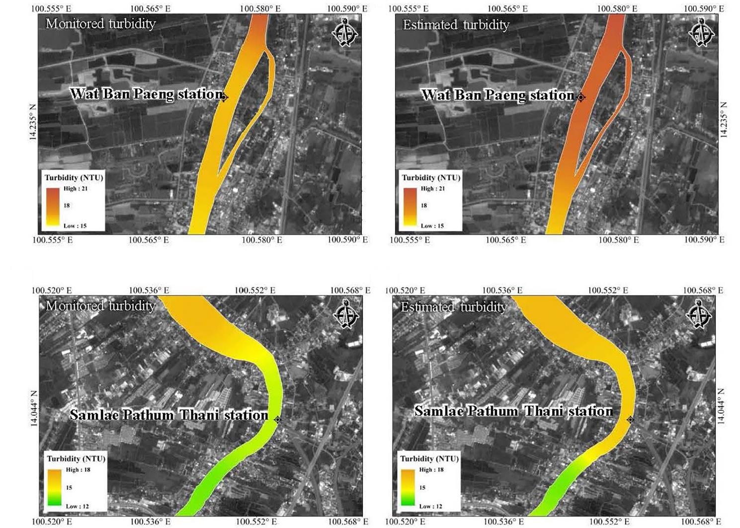
Turbidity is a standard water quality parameter that indicates its optical property in scattering light along the column containing suspended particles. The satellite imagery information of Sentinel-2 and the Chao Phraya River turbidity data from December 2016 to February 2021 was applied to develop a mathematical equation for turbidity determination. This practical and straightforward approach eliminates some constraints of traditional laboratory analysis, which is labour-intensive and time-consuming in monitoring the entire river. Four studied steps were implemented: data pre-processing, correlating analysis of numerical turbidity and satellite image reflectance, developing the mathematic equations for turbidity estimation, and its validation of use. Four different bands (B2, B3, B4, and B8) and three selection methods were investigated; single-band, combination band, and ratio band. The obtained results depicted that the reflectance of B4 in the single-band process promoted the highest correlation with turbidity compared to the others. The reflectance in visible wavelengths increased when the turbidity of river water increased, particularly B4. The mathematical power equation was a more suitable function for evaluating turbidity than linear regression, quadratic, and exponential functions. A similar concentration was obtained for measured and estimated turbidity in the validation. This finding demonstrated the potential application of remotely sensed data to estimate river water turbidity with high capability and accuracy that adequately supports spatial data continuity acquisition.
Article Details

This work is licensed under a Creative Commons Attribution-NonCommercial 4.0 International License.
Published articles are under the copyright of the Environment and Natural Resources Journal effective when the article is accepted for publication thus granting Environment and Natural Resources Journal all rights for the work so that both parties may be protected from the consequences of unauthorized use. Partially or totally publication of an article elsewhere is possible only after the consent from the editors.
References
Acharya TD, Subedi A, Lee DH. Evaluation of water indices for surface water extraction in a Landsat 8 scene of Nepal. Sensors 2018;18(8):Article No. 2580.
Aisabokhae JE, Oresajo SB. Supervised classification of Landsat-8 band ratio images for geological interpretation of Sokoto, Nigeria. South African Journal of Geomatics 2018;7(3):360-71.
Ali SA, Ahmad A. Analysing water-borne diseases susceptibility in Kolkata Municipal Corporation using WQI and GIS based Kriging interpolation. GeoJournal 2020;85(4):1151-74.
Alvado B, Soria-Perpinya X, Vicente E, Delegido J, Urrego P, Ruiz-Verdu A, et al. Estimating organic and inorganic part of suspended solids from Sentinel 2 in different inland waters. Water 2021;13(18):Article No. 2453.
Baughman CA, Jones BM, Bartz KK, Young DB, Zimmerman CE. Reconstructing turbidity in a glacially influenced lake using the Landsat TM and ETM+ surface reflectance climate data record archive, Lake Clark, Alaska. Remote Sensing 2015;7(10):13692-710.
Caballero I, Stumpf RP, Meredith A. Preliminary assessment of turbidity and chlorophyll impact on bathymetry derived from Sentinel-2A and Sentinel-3A satellites in South Florida. Remote Sensing 2019;11(6):Article No. 645.
Chauhan A, Singh RP. Decline in PM2.5 concentrations over major cities around the world associated with COVID-19. Environmental Research 2020;187:Article No. 109634.
Chen J, Zhu W, Tian YQ, Yu Q. Monitoring dissolved organic carbon by combining Landsat-8 and Sentinel-2 satellites: Case study in Saginaw River estuary, Lake Huron. Science of the Total Environment 2020;718:Article No. 137374.
Clevers JG, Gitelson AA. Remote estimation of crop and grass chlorophyll and nitrogen content using red-edge bands on Sentinel-2 and -3. International Journal of Applied Earth Observation and Geoinformation 2013;23:344-51.
Collivignarelli MC, Abbà A, Bertanza G, Pedrazzani R, Ricciardi P, Miino MC. Lockdown for CoViD-2019 in Milan: What are the effects on air quality? Science of the Total Environment 2020;732:Article No. 139280.
Dixon MT. Exploring the Effects of Social Media Use and Avoidant Attachment Style on Marital Satisfaction and Cyber Infidelity [dissertation]. Atlanta, Mercer University; 2020.
Ehmann K, Kelleher C, Condon LE. Monitoring turbidity from above: Deploying small unoccupied aerial vehicles to image in‐stream turbidity. Hydrological Processes 2019;33(6):1013-21.
Eleveld MA, Pasterkamp R, van der Woerd HJ, Pietrzak JD. Remotely sensed seasonality in the spatial distribution of sea-surface suspended particulate matter in the southern North Sea. Estuarine, Coastal and Shelf Science 2008;80(1):103-13.
Elhag M, Gitas I, Othman A, Bahrawi J, Gikas P. Assessment of water quality parameters using temporal remote sensing spectral reflectance in arid environments, Saudi Arabia. Water. 2019;11(3):Article No. 556.
Fujiwara T, Takeuchi W. Simulation of Sentinel-2 bottom of atmosphere reflectance using shadow parameters on a Deciduous Forest in Thailand. ISPRS International Journal of Geo-Information 2020;9(10):Article No. 582.
Gani A, Ion W, Yang E. Optimisation of cutting parameters and surface deformation during thin steel sheets plasma processing using Taguchi approach. Advances in Mechanical Engineering 2021;13(7):1-19.
Garg V, Aggarwal SP, Chauhan P. Changes in turbidity along Ganga River using Sentinel-2 satellite data during lockdown associated with COVID-19. Geomatics, Natural Hazards and Risk 2020;11(1):1175-95.
Gholizadeh MH, Melesse AM, Reddi L. A comprehensive review on water quality parameters estimation using remote sensing techniques. Sensors 2016;16(8):Article No. 1298.
Giardino C, Pepe M, Brivio PA, Ghezzi P, Zilioli E. Detecting chlorophyll, Secchi disk depth and surface temperature in a sub-alpine lake using Landsat imagery. Science of the Total Environment 2001;268(1-3):19-29.
Gikas P, Tchobanoglous G. The role of satellite and decentralized strategies in water resources management. Journal of Environmental Management 2009;90(1):144-52.
Gohin F, Bryère P, Lefebvre A, Sauriau P-G, Savoye N, Vantrepotte V, et al. Satellite and in situ monitoring of Chl-a, turbidity, and total suspended matter in coastal waters: Experience of the year 2017 along the French Coasts. Journal of Marine Science and Engineering 2020;8(9):Article No. 665.
Güttler FN, Niculescu S, Gohin F. Turbidity retrieval and monitoring of Danube Delta waters using multi-sensor optical remote sensing data: An integrated view from the delta plain lakes to the western-northwestern Black Sea coastal zone. Remote Sensing of Environment 2013;132:86-101.
Hossain A, Mathias C, Blanton R. Remote sensing of turbidity in the Tennessee River using Landsat 8 satellite. Remote Sensing 2021;13(18):Article No. 3785.
Jayaweera C, Aziz N. Reliability of principal component analysis and pearson correlation coefficient, for application in artificial neural network model development, for water treatment plants. IOP Conference Series: Materials Science and Engineering 2018;458:Article No. 012076.
Ketkeaw T, Thanuttamavong M, Kaveeta R. Effects of land use on water quality in Samrong Canal, Samut Prakan Province. Journal of Science and Technology 2019;21(1):175-83.
Li C, Wong WH. Model-based analysis of oligonucleotide arrays: Model validation, design issues and standard error application. Genome Biology 2001;2(8):1-11.
Li W, Niu Z, Shang R, Qin Y, Wang L, Chen H. High-resolution mapping of forest canopy height using machine learning by coupling ICESat-2 LiDAR with Sentinel-1, Sentinel-2 and Landsat-8 data. International Journal of Applied Earth Observation and Geoinformation 2020;92:Article No. 102163.
Louis J, Pflug B, Main-Knorn M, Debaecker V, Mueller-Wilm U, Iannone RQ, et al. Sentinel-2 global surface reflectance level-2A product generated with Sen2Cor. Proceedings of IEEE International Geoscience and Remote Sensing Symposium; 2019 Jul 28-Aug 2; Yokohama: Japan; 2019.
Luis KM, Rheuban JE, Kavanaugh MT, Glover DM, Wei J, Lee Z, et al. Capturing coastal water clarity variability with Landsat 8. Marine Pollution Bulletin 2019;145:96-104.
Marina P, Snezana M, Maja N, Miroslava M. Determination of heavy metal concentration and correlation analysis of turbidity: A case study of the Zlot source (Bor, Serbia). Water, Air, and Soil Pollution 2020;231(3):1-12.
Miller RL, McKee BA. Using MODIS Terra 250 m imagery to map concentrations of total suspended matter in coastal waters. Remote Sensing of Environment 2004;93(1-2):259-66.
Mulliss RM, Revitt DM, Shutes RB. The impacts of urban discharges on the hydrology and water quality of an urban watercourse. Science of the Total Environment 1996;189: 385-90.
Neill SP, Hashemi MR. Fundamentals of Ocean Renewable Energy: Generating Electricity from the Sea. London, United Kingdom, Elsevier Academic Press; 2018.
Neukermans G, Loisel H, Mériaux X, Astoreca R, McKee D. In situ variability of mass‐specific beam attenuation and backscattering of marine particles with respect to particle size, density, and composition. Limnology and Oceanography 2012;57(1):124-44.
Ouma YO, Noor K, Herbert K. Modelling reservoir chlorophyll-a, TSS, and turbidity using Sentinel-2A MSI and Landsat-8 OLI satellite sensors with empirical multivariate regression. Journal of Sensors 2020;2020:Article No. 8858408.
Ouma YO, Waga J, Okech M, Lavisa O, Mbuthia D. Estimation of reservoir bio-optical water quality parameters using smartphone sensor apps and Landsat ETM+: Review and comparative experimental results. Journal of Sensors 2018;2018:Article No. 3490757.
Pavelsky TM, Smith LC. Remote sensing of suspended sediment concentration, flow velocity, and lake recharge in the Peace‐Athabasca Delta, Canada. Water Resources Research 2009;45(11):Article No. W11417.
Quang NH, Sasaki J, Higa H, Huan NH. Spatiotemporal variation of turbidity based on landsat 8 oli in cam ranh bay and thuy trieu lagoon, Vietnam. Water 2017;9(8):Article No. 570.
Raiyani K, Gonçalves T, Rato L, Salgueiro P, Marques da Silva JR. Sentinel-2 image scene classification: A comparison between Sen2Cor and a machine learning approach. Remote Sensing 2021;13(2):Article No. 300.
Sahavacharin A, Likitswat F. Landscape ecological structure of Peri-Urban agricultural area in Bangkok Metropolitan Region. Journal of Community Development and Life Quality 2019;7(2);180-91.
Schumacker RE, Lomax RG. A beginner’s guide to structural equation modeling. London, United Kingdom: Psychology Press; 2004.
Sebastia-Frasquet M-T, Aguilar-Maldonado JA, Santamaria-Del-Angel E, Estornell J. Sentinel 2 analysis of turbidity patterns in a coastal lagoon. Remote Sensing 2019;11(24):Article No. 2926.
Shen M, Duan H, Cao Z, Xue K, Loiselle S, Yesou H. Determination of the downwelling diffuse attenuation coefficient of lake water with the sentinel-3A OLCI. Remote Sensing 2017;9(12):Article No. 1246.
Shi L, Mao Z, Wang Z, Retrieval of total suspended matter concentrations from high resolution WorldView-2 imagery: a case study of inland rivers. IOP Conference Series: Earth and Environmental Science 2018;121(3):Article No. 032036.
Sillberg CV, Kullavanijaya P, Chavalparit O. Water quality classification by integration of attribute-realization and support vector machine for the Chao Phraya River. Journal of Ecological Engineering 2021;22(9):70-86.
Soria X, Delegido J, Urrego E, Pereira-Sandoval M, Vicente E, Ruiz-Verdu A, et al. Validación de algoritmos para la estimación de la clorofila-a con Sentinel-2 en la Albufera de València. Proceedings of the XVII Congreso de la Asociacion Espanola de Teledeteccion; 2017 Oct 3-7; Murcia, Spain; 2017.
Suwanlertcharoen T, Prukpitikula S, Buakaewa V. Retrieval of water turbidity using sentinel-2 image time series to enhance water quality assessment for consumption. Journal of Environmental Management 2020;16:74-93.
Tian X, An C, Chen Z, Tian Z. Assessing the impact of COVID-19 pandemic on urban transportation and air quality in Canada. Science of the Total Environment 2021;765:Article No. 144270.
Toming K, Kutser T, Laas A, Sepp M, Paavel B, Nõges T. First experiences in mapping lake water quality parameters with Sentinel-2 MSI imagery. Remote Sensing 2016;8(8):Article No. 640.
Trinh RC, Fichot CG, Gierach MM, Holt B, Malakar NK, Hulley G, et al. Application of Landsat 8 for monitoring impacts of wastewater discharge on coastal water quality. Frontiers in Marine Science 2017;4:Article No. 329.
Twumasi N, Shao Z, Altan O. Mapping built-up areas using two band ratio on Landsat imagery of Accra in Ghana from 1980 to 2017. Applied Ecology and Environmental Research 2019;17:13147-68.
Vanhellemont Q. Daily metre-scale mapping of water turbidity using CubeSat imagery. Optics Express 2019;27(20):1372-99.
Wang Q, Shi W, Li Z, Atkinson PM. Fusion of Sentinel-2 images. Remote Sensing of Environment 2016;187:241-52.
Wernand M, Hommersom A, van der Woerd HJ. MERIS-based ocean colour classification with the discrete Forel-Ule scale. Ocean Science 2013;9(3):477-87.
Yao R, Cai L, Liu J, Zhou M. GF-1 Satellite observations of suspended sediment injection of Yellow River Estuary, China. Remote Sensing 2020;12(19):Article No. 3126.
Yunus AP, Masago Y, Hijioka Y. COVID-19 and surface water quality: Improved lake water quality during the lockdown. Science of the Total Environment 2020;731:Article No. 139012.
