Mapping Degraded Area for Tropical Peatland Revegetation Using Forest Canopy Density Model Landsat 8 OLI-TIRS in Central Kalimantan, Indonesia 10.32526/ennrj/20/202200008
Article Sidebar
Main Article Content
Abstract
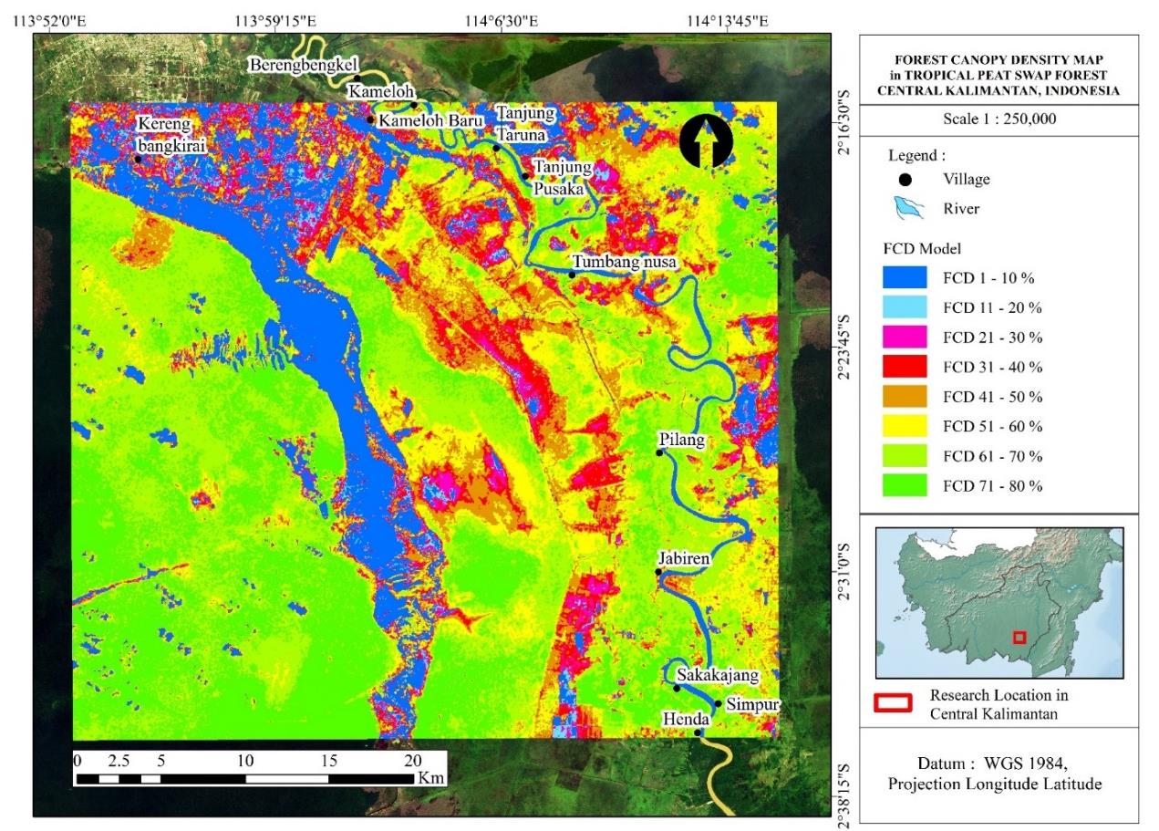
Peatland rehabilitation in Indonesia has been massively carried out since 2016 following a huge fire event in 2015. Rehabilitation efforts have so far focused only on burned areas, although non-forested areas and areas with a limited number of juveniles must also be considered for natural regeneration. Spatial mapping can identify areas that need revegetation so that resources can be used more effectively and efficiently. This study aims to map potential areas for peatland rehabilitation by determining the distribution of tree canopy cover using the Forest Canopy Density (FCD) model from Landsat 8 OLI. The area selected for study was Ex-Mega Rice Project (MRP) area in Pulang Pisau district and Palangka Raya city, which burns almost every year. The study identifies eight areas with different levels of Forest Cover Density (FCD). Our field observation confirms that the eight different areas have different levels of natural revegetation. When forest cover is 1-30% of the FCD model, natural regeneration is insufficient and revegetation is required. This study found that 34,543.3 ha or 22.1% of the area of the MRP needs to be rehabilitated. This result provides information on which areas can be naturally revegetated and which areas need to be rehabilitated. This information is important to develop a peat restoration strategy and increase the likelihood of success.
Article Details

This work is licensed under a Creative Commons Attribution-NonCommercial 4.0 International License.
Published articles are under the copyright of the Environment and Natural Resources Journal effective when the article is accepted for publication thus granting Environment and Natural Resources Journal all rights for the work so that both parties may be protected from the consequences of unauthorized use. Partially or totally publication of an article elsewhere is possible only after the consent from the editors.
References
Anda M, Ritung S, Suryani E, Sukarman, Hikmat M, Yatno E, et al. Revisiting tropical peatlands in Indonesia: Semi-detailed mapping, extent and depth distribution assessment. Geoderma 2021;402:Article No. 115235.
Andriesse JP. Nature and Management of Tropical Peat Soils. Rome, Italy: Soil Resources, Management and Conservation Service, FAO Land and Water Development Division; 1988.
Anshari GZ, Gusmayanti E, Novita N. The use of subsidence to estimate carbon loss from deforested and drained tropical peatlands in Indonesia. Forests 2021;12(6):Article No. 732.
Azadeh A, Dimitrios P, Peter S. Forest canopy density assessment using different approaches: Review. Journal of Forest Science 2017;63(3):107-16.
Cattau ME, Harrison ME, Shinyo I, Tungau S, Uriarte M, De Fries R. Sources of anthropogenic fire ignitions on the peat-swamp landscape in Kalimantan, Indonesia. Global Environmental Change 2016;39:205-19.
Chandrashekhar MB, Saran S, Raju PLN, Roy PS. Forest canopy density stratification: How relevant is biophysical spectral response modelling approach? Geocarto International 2005; 20(1):15-21.
Cheyne SM, Macdonald DW. Wild felid diversity and activity patterns in Sabangau peat-swamp forest, Indonesian Borneo. Oryx 2011;45(1):119-24.
Daryono H. Potentials, problems and policies required in sustainable management of forests and peat swamps. Jurnal Analisis Kebijakan Kehutanan 2009;6(2):71-101. (in Indonesian).
Dianti A, Ratnasari NG, Palamba P, Nugroho Y. Effect of rewetting on smouldering combustion of a tropical peat. E3S Web of Conferences 2018;67:Article No. 02042.
Dohong A, Aziz AA, Dargusch P. A review of the drivers of tropical peatland degradation in South-East Asia. Land Use Policy 2017;69:349-60.
Foody GM. Harshness in image classification accuracy assessment. International Journal of Remote Sensing 2008;29(11):3137-58.
Government of Indonesia. Presidential Decree No. 82/1995 Concerning Peatland Development for Food Crops Agriculture in Central Kalimantan. Jakarta, Indonesia: Government of Indonesia; 1995. (in Indonesian).
Glauber AJ, Moyer S, Adriani M, Gunawan I, Mileva E, Harimurti P, et al. Losses from Forest Fires, Economic Impact Analysis and the 2015 Fire Crisis. Jakarta, Indonesia: Indonesia Sustainable Landscape Knowledge; 2016. (in Indonesian).
Graham LLB, Giesen W, Page SE. A common-sense approach to tropical peat swamp forest restoration in Southeast Asia. Restoration Ecology 2017;25(2):312-21.
Himayah S, Hartono H, Danoedoro P. Utilization of multitemporal Landsat 8 imagery and Forest Canopy Density (FCD) model for analysis of changes in forest canopy density in the Faculty of Geography, Gadjah Mada University, Gunung Kelud, East Java. Majalah Geografi Indonesia 2017;31(1):65-72. (in Indonesian).
Hirano T, Jauhiainen J, Inoue T, Takahashi H. Controls on the carbon balance of tropical peatlands. Ecosystems 2009; 12(6):873-87.
Jessup T, Segah H, Silvius M, Applegate G, Jagau Y. An integrated landscape approach for socially inclusive peatland restoration. Journal of Wetlands Environmental Management 2020;8(1):77-84.
Mann D, Agrawal G, Joshi PK. Spatio-temporal forest cover dynamics along road networks in the Central Himalaya. Ecological Engineering 2019;127:383-93.
Ministry of Agriculture. Peatland Map of Indonesia 1:250.000 Scale. Jakarta, Indonesia: Ministry of Agriculture; 2011. (in Indonesian).
Ministry of Forestry. Decree of the Indonesian Ministry of Forestry No. 200/Kpts-II/1994 Concerning Criteria for Unproductive Natural Production Forest. Jakarta, Indonesia: Ministry of Forestry; 1994. (in Indonesian).
Ohkubo S, Hirano T, Kusin K. Influence of fire and drainage on evapotranspiration in a degraded peat swamp forest in Central Kalimantan, Indonesia. Journal of Hydrology 2021;603: Article No. 126906.
Page SE, Rieley JO, Banks CJ. Global and regional importance of the tropical peatland carbon pool. Global Change Biology 2011;17(2):798-818.
Peat Restoration Agency. Initiating Indonesian Peat Restoration. Jakarta, Indonesia: Peat Restoration Agency (BRG); 2016. (in Indonesian).
Rachmanadi D, Faridah E, Van Der Meer PJ. Diversity of vegetation regeneration potential in peat swamp forest: A case study in a special purpose forest area (KHDTK) Tumbang Nusa, Central Kalimantan. Jurnal Ilmu Kehutanan 2017; 11(2):224-38. (in Indonesian).
Ramdhan M, Siregar ZA. Management of peat areas through empowerment of coastal village communities in the Katingan River and Mentaya River Peat Hydrological Areas, Central Kalimantan Province. Jurnal Segara 2018;4(3):145-57. (in Indonesian).
Rikimaru A. Landsat TM data processing guide for forest canopy density mapping and monitoring model. Proceedings of the ITTO Workshop on Utilization of Remote Sensing in Site Assessment and Planting of Logged-over Forest; 1996 Jul 30-Aug 1; Bangkok: Thailand; 1996.
Rikimaru A, Miyatake S. Development of forest canopy density mapping and monitoring model using indices of vegetation, bare soil and shadow. Proceedings of the 18th Asian Conference on Remote Sensing; 1997 Oct 20-24; Kuala Lumpur: Malaysia; 1997.
Roy PS, Rikimaru A, Miyatake S. Biophysical spectral response modeling approach for forest density stratification. Proceedings of the 18th Asian Conference on Remote Sensing; 1997 Oct 20-24; Kuala Lumpur: Malaysia; 1997.
Sukarna RM, Birawa C, Junaedi A. Mapping above-ground carbon stock of secondary peat swamp forest using Forest Canopy Density model Landsat 8 OLI-TIRS: A case study in Central Kalimantan Indonesia. Environment and Natural Resources Journal 2021;19(2):165-75.
Surahman A, Soni P, Shivakoti GP. Are peatland farming systems sustainable? Case study on assessing existing farming systems in the peatland of Central Kalimantan, Indonesia. Journal of Integrative Environmental Sciences 2018;15(1):1-9.
Susilo GE, Yamamoto K, Imai T. Modeling groundwater level fluctuation in the tropical peatland areas under the effect of El Nino. Procedia Environmental Sciences 2013;17:119-28.
Suwito D, Suratman, Poejirahajoe E. Peat swamp forest-firesimpacts on local livelihoods: A case study in Kapuas Kahayan Protected Forest Management Unit, Central Kalimantan, Indonesia. IOP Conference Series: Earth and Environmental Science 2020;451(1):Article No. 012097.
Tan ZD, Lupascu M, Wijedasa LS. Paludiculture as a sustainable land use alternative for tropical peatlands: A review. Science of the Total Environment 2020;753:Article No. 142111.
Tata HL, Susmianto A. The Prospect of Paludiculture in Indonesia’s Peat Ecosystem. Jakarta, Indonesia: Forda; 2019. (in Indonesian).
Tonks AJ, Aplin P, Beriro DJ, Cooper H, Evers S, Vane CH, et al. Impacts of conversion of tropical peat swamp forest to oil palm plantation on peat organic chemistry, physical properties and carbon stocks. Geoderma 2017;289:36-45.
Usup A, Afentina A, Aguswan Y. Climate change mitigation through forest fire prevention and peatland rewetting programs in Central Kalimantan Indonesia. Journal of Ecological Engineering 2021;22(11):230-8.
Wahyunto, Ritung S, Suparto, Subagjo H. Distribution of Peat and Carbon Content in Sumatra and Kalimantan. Jakarta, Indonesia: Climate Change Project, Forests and Peatlands in Indonesia; 2005. (in Indonesian).
Wich SA, Meijaard E, Marshall AJ, Husson S, Ancrenaz M, Lacy RC, et al. Distribution and conservation status of the orang-utan (Pongo spp.) on Borneo and Sumatra: How many remain? Oryx 2008;42(03):329-39.
Wyatt-Smith J, Panton W. Manual of Malayan Silviculture for Inland Forest. Kuala Lumpur, Malaysia: Forest Research Institute; 1995.
Xu J, Morris PJ, Liu J, Holden J. PEATMAP: Refining estimates of global peatland distribution based on a meta-analysis. Catena 2018;160:134-40.
Yuningsih L, Bastoni, Yulianty T, Harbi J. Vegetation analysis on Burnt Peat Forest Land in Ogan Komering Ilir (OKI) District, South Sumatra Province. Sylva 2018;7(2):58-67. (in Indonesian).
