Agricultural Land Dryness Distribution Using the Normalized Difference Drought Index (NDDI) Algorithm on Landsat 8 Imagery in Eromoko, Indonesia 10.32526/ennrj/21/202200157
Article Sidebar
Main Article Content
Abstract
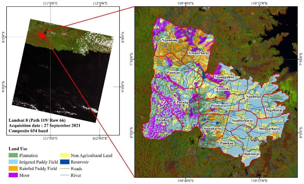
The study area, Eromoko, has agricultural land covering 79.76% of the area, which experiences drought every year, causing a decrease in crop yields. Information on agricultural land dryness is needed to reduce the impact of dryness conditions on the agricultural sector. The effect of drought can be minimized using the transformation of the Normalized Difference Drought Index (NDDI) algorithm on Landsat 8 Imagery because it is considered capable of being used for land drought analysis that is accurate and efficient in time and cost. This study created a model for estimating soil moisture with actual soil moisture as the dependent variable and NDDI as the independent variable in several agricultural land uses in Eromoko. The results showed that the estimation model could estimate soil moisture with accuracy in plantations at 85.31%, irrigated paddy fields at 75.99%, rainfed paddy fields at 76.62%, and moors at 88.48%. The dryness category in the study area is 3,314.82 ha (35% of the total area). The variability of land use greatly affects the drying conditions. Dryness conditions can be reduced by controlling the dryness factors. Mitigation efforts to maintain soil moisture include irrigation planning based on the estimation model, applying bio-mulch and organic mulch, organic fertilization, and meeting water requirements in the harvesting period.
Article Details

This work is licensed under a Creative Commons Attribution-NonCommercial 4.0 International License.
Published articles are under the copyright of the Environment and Natural Resources Journal effective when the article is accepted for publication thus granting Environment and Natural Resources Journal all rights for the work so that both parties may be protected from the consequences of unauthorized use. Partially or totally publication of an article elsewhere is possible only after the consent from the editors.
References
Abdallah MAB, Durfee N, Mata-Gonzalez R, Ochoa CG, Noller JS. Water use and soil moisture relationships on western juniper trees at different growth stages. Water 2020;12(6): 26-31.
Adimihardja A, Haryati U, Juarsah I. Determination of soil moisture content using the gravimetric method. In: Technical Manual for Soil Physics Analysis. Bogor: Indonesian Center for Agricultural Land Resources Research and Development; 2006. p. 132-42.
Adunya T, Benti FC. The impacts of climate-induced agricultural drought on four cereal crops: A case study in Bako Tibe District, Oromia National Regional State, Ethiopia. Caraka Tani: Journal of Sustainable Agriculture 2020;35(1):135-46.
Akbari AN, Jatmiko RH. Utilization of landsat 8 oil images and geographic information systems for soil organic matter content mapping in Karanganyar Regency. Jurnal Bumi Indonesia 2016;5(1):10-1.
Archer NAL, Otten W, Schmidt S, Bengough AG, Shah N, Bonell M. Rainfall infiltration and soil hydrological characteristics below ancient forest, planted forest and grassland in a temperate northern climate. Ecohydrology 2016;9(4):585-600.
Benti F, Abara M. Trend analyses of temperature and rainfall and their response to global CO2 emission in Masha, Southern Ethiopia. Caraka Tani: Journal of Sustainable Agriculture 2019;34(1):67-75.
Bronto S, Mulyaningsih S, Hartono G, Astuti. Parangjoho and songputri reservoirs: Alternative eruption sources for the semilir formation in the Eromoko area, Wonogiri Regency, Central Java. Indonesian Journal on Geoscience 2009; 4(2):79-92.
Browne M, Yardimci NT, Scoffoni C, Jarrahi M, Sack L. Prediction of leaf water potential and relative water content using terahertz radiation spectroscopy. Plant Direct 2020; 4(4):e00197.
Burapapol K, Nagasawa R. Mapping soil moisture as an indicator of wildfire risk using landsat 8 images in Sri Lanna National Park, Northern Thailand. Journal of Agricultural Science 2016;8(10):107-19.
Busari MA, Kukal SS, Kaur A, Bhatt R, Dulazi AA. Conservation tillage impacts on soil, crop and the environment. International Soil and Water Conservation Research 2015;3(2):119-29.
Central Bureau of Statistics of Wonogiri Regency. Harvest Area and Rice Production in Wonogiri Regency 2020. Wonogiri: Central Bureau of Statistics of Wonogiri Regency; 2020.
Central Java Geoportal. Geospatial data and information [Internet]. 2019 [cited 2021 Jul 15]. Available from: http://geoportal.jatengprov.go.id/.
Dobri RV, Sfîcă L, Amihăesei VA, Apostol L, Țîmpu S. Drought extent and severity on arable lands in romania derived from normalized difference drought index (2001-2020). Remote Sensing 2021;13(8):Article No. 1478.
Domiri DD. The new method for detecting early planting and bare land condition in paddy field by using vegetation bare water index. Proceedings of the 2nd International Conference of Indonesian Society for Remote Sensing (ICOIRS 2016); 2017 Dec 17-20; The Sahid Rich Jogja, Yogyakarta: Indonesia; 2016.
Eliyani, Handoko, Koesmaryono Y. Water deficit effect on growth of young fast growing teak (Tectona grandis L.F.). Agromet 2005;19(1):11-20.
Faiz AM, Prijono S. Differences in the ability of soil to hold water on various slopes of coffee land in the Sumbermanjing Wetan area, Malang Regency. Jurnal Tanah Dan Sumberdaya Lahan 2021;8(2):481-91.
Fawzi NI, Husna VN. Landsat 8: A Basic Processing Theory and Technique. Bengkulu: Elmarkazi Publisher; 2021.
Finch HJS, Samuel AM, Lane GPF. Soils and soil management. In: Lockhart and Wiseman’s Crop Husbandry Including Grassland. 9th ed. England: Woodhead Publishing; 2014. p. 37-62.
Gao B-C. NDWI: A normalized difference water index for remote sensing of vegetation liquid water from space. Remote Sensing of Environment 1996;58:257-66.
Ghazali MF, Wikantika K, Harto AB, Kondoh A. Generating soil salinity, soil moisture, soil pH from satellite imagery and its analysis. Information Processing in Agriculture 2020; 7(2):294-306.
Gu Y, Brown JF, Verdin JP, Wardlow B. A five-year analysis of MODIS NDVI and NDWI for grassland drought assessment over the central Great Plains of the United States. Geophysical Research Letters 2007;34(6):1-6.
Gulácsi A, Kovács F. Drought monitoring of forest vegetation using modis-based normalized difference drought index in Hungary. Hungarian Geographical Bulletin 2018;67(1):29-42.
Hayes MJ, Svoboda MD, Wardlow BD, Anderson MC, Kogan F. Drought monitoring: Historical and current perspectives. In: Remote Sensing of Drought: Innovative Monitoring Approaches. CRC Press; 2012. p. 1-19.
Hazaymeh K, Hassan QK. A remote sensing-based agricultural drought indicator and its implementation over a semi-arid region, Jordan. Journal of Arid Land 2017;9(3):319-30.
Hidayat AM, Efendi U, Agustina L, Winarso PA. The correlation of the nino 3.4 index and the southern oscillation index (SOI) with variations in rainfall in Semarang. Journal of Science and Weather Modification Technology 2018;19(2):75-81.
Ignatius SR. Potential water resources and calculation of rainwater storage volume to overcome water shortage in South Wonogiri. Journal of Rural and Development 2013; 4(2):157-66.
Kaye JP, Quemada M. Using cover crops to mitigate and adapt to climate change: A review. Agronomy for Sustainable Development 2017;37(4):1-17.
Kusumandari A, Pratiwi I, Widiasmoro S. Run off prediction by using small plots at teak forest, dry land and settlement areas in Pitu village, Ngawi, East Java. IOP Conference Series: Earth and Environmental Science 2020;449:Article No. 012040.
Liu C, Yang C, Yang Q, Wang J. Spatiotemporal drought analysis by the standardized precipitation index (SPI) and standardized precipitation evapotranspiration index (SPEI) in Sichuan Province, China. Scientific Reports 2021;11(1):1-14.
Maharani D, Sudomo A, Swestiani D, Murniati, Sabastian GE, Roshetko JM, et al. Intercropping tuber crops with teak in Gunungkidul Regency, Yogyakarta, Indonesia. Agronomy 2022;12(2):1-20.
Maulana FW. Aquifer potential of Eromoko Village, Eromoko District, Wonogiri Regency, Central Java Province based on geoelectrical data. Teknomineral 2019;1(2):79-87.
Muchsin F, Harmoko A, Prasasti I, Rahayu MI, Pradhono KA, Technology RS. Comparison of the radiometric correction of landsat-8 images based on object spectral response. International Journal of Remote Sensing and Earth Sciences 2022;18(2):177-88.
National Disaster Management Coordinating Board. Introduction to Disaster Characteristics and Mitigation Efforts in Indonesia. National Disaster Management Coordinating Board; 2007.
Noelle NM, Weru WP, Rodrigue SJ, Karlin G. The effects of drought on rice cultivation in sub-Saharan Africa and its mitigation: A review. African Journal of Agricultural Research 2018;13(25):1257-71.
O’Connell NV, Snyder RL. Cover crops, mulch lower night temperatures in citrus. California Agriculture 1999;53(5):37-40.
Orimoloye IR, Kalumba AM, Mazinyo SP, Nel W. Geospatial analysis of wetland dynamics: Wetland depletion and biodiversity conservation of Isimangaliso Wetland, South Africa. Journal of King Saud University - Sciences 2020; 32(1):90-6.
Polthanee A, Promkhambut A. Impact of climate change on rice-based cropping systems and farmers’ adaptation strategies in Northeast Thailand. Asian Journal of Crop Science 2014;6(3):262-72.
Popova Z, Ivanova M, Martins D, Pereira LS, Doneva K, Alexandrov V, et al. Vulnerability of Bulgarian agriculture to drought and climate variability with focus on rainfed maize systems. Natural Hazards 2014;74(2):865-86.
Qin J, Hu F, Zhang B, Wei Z, Li H. Role of straw mulching in non-continuously flooded rice cultivation. Agricultural Water Management 2006;83(3):252-60.
Reddy RM, Ramkumar. Prospect and importance of green mulching on the soil status of tropical tasar plantation fields in India. Nature Precedings 2011;1-13.
Renza D, Martinez E, Arquero A, Sanchez J. Drought estimation maps by means of multidate landsat fused images. Proceedings of the 30th EARSeL Symposium Remote Sensing for Science, Education, and Natural and Cultural Heritage; 2010 31 May-3 Jun; París, Francia; 2010.
Research Agency for Solo Watershed Area. Daily rainfall data [Internet]. 2020. [cited 2021 Jul 15]. Available from: https://bbwsbengawansolo.id/.
Shahidan MF, Salleh E, Mustafa KMS. Effects of tree canopies on solar radiation filtration in a tropical microclimatic environment. Proceedings of the 24th Conference on Passive and Low Energy Architecture (PLEA2007); 2007 Nov 22-24; National University of Singapore, Singapore; 2007.
Song X, Zhou G, He Q. Critical leaf water content for maize photosynthesis under drought stress and its response to rewatering. Sustainability 2021;13(13):1-14.
Srivastava A, Kumari N, Maza M. Hydrological response to agricultural land use heterogeneity using variable infiltration capacity model. Water Resources Management 2020; 34(12):3779-94.
Sudirman, Sutono S, Juarsah I. Determination of groundwater retention in the laboratory. In: Technical Manual for Soil Physics Analysis. Bogor: Indonesian Center for Agricultural Land Resources Research and Development; 2006. p. 167-76.
Sukmono A. Rice fields drought identification using a combination of leaf water content index and vegetation index with landsat 8 imagery. Elipsoida: Jurnal Geodesi Dan Geomatika 2018;1(2):44-50.
Syaranamual S, Sipyan D, Tuhumena VL. The seedlings growth performance of areca nut palm (Areca catechu L.) Under different types of organic mulching. Caraka Tani: Journal of Sustainable Agriculture 2022;37(2):233-42.
Tarigan PL, Tohari T, Suryanto P. Physiological response of upland rice varieties to furrow with organic matter on agroforestry system with kayu putih (Melaleuca leucadendra L.). Caraka Tani: Journal of Sustainable Agriculture 2019; 34(2):223-31.
USGS. Landsat missions [Internet]. 2008 [cited 2021 Mar 31]. Available from: https://www.usgs.gov/core-science-systems/ nli/landsat/landsat-8?qt-science_support_page_related_con =0#qt-science_support_page_related_con.
Velasco-Muñoz JF, Aznar-Sánchez JA, Batlles-delaFuente A, Fidelibus MD. Rainwater harvesting for agricultural irrigation: An analysis of global research. Water 2019;11(7):1-18.
Vengadaramana A, Jashothan PT. Effect of organic fertilizers on the water holding capacity of soil in different terrains of Jaffna peninsula in Sri Lanka. Journal of Natural Product Plant Resources 2012;2(4):500-3.
Voroney P. Soils for Horse Pasture Management. Horse Pasture Management: Elsevier Inc.; 2018. p. 65-79.
Wahyunie RE, Baskoro DPT, Sofyan M. Water retention capacity and resistence of soil penetration in intensive tillage system and conservation soil tillage. Journal of Soil Science and Environment 2012;14(2):73-8.
Wild A. Soils and the Environment: An Introduction. Melbourne: Cambridge University Press; 1993.
Yang L, Wei W, Chen L, Chen W, Wang J. Response of temporal variation of soil moisture to vegetation restoration in semi-arid Loess Plateau, China. Catena 2014;115:123-33.
