Evaluation of Land Use Land Cover Changes in Nan Province, Thailand, Using Multi-Sensor Satellite Data and Google Earth Engine 10.32526/ennrj/21/202200200
Article Sidebar
Main Article Content
Abstract
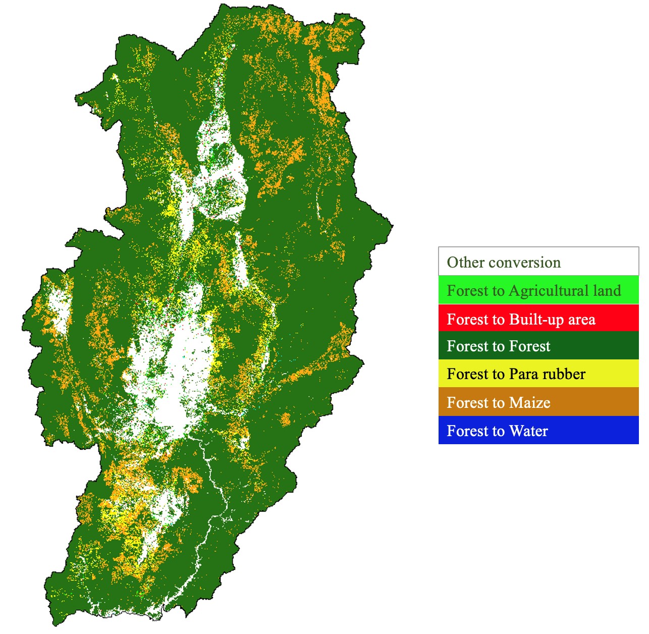
Land use and land cover (LULC) conversion has become a chronic problem in Nan province. The primary factors of changes are lacking arable land, agricultural practices, and agriculture expansion. This study evaluated the usefulness of multi-sensor Landsat-5 (LS5), Landsat-8 (LS8), Sentinel-1 (S1), and Sentinel-2 (S2) satellite data for monitoring changes in LULC in Nan province, Thailand during a 30-year period (1990-2019), using a random forest (RF) model and the cloud-based Google Earth Engine (GEE) platform. Information of established land management policies was also used to describe the LULC changes. The median composite of the input variables selection from multi-sensor data were used to generate datasets. A total of 36 datasets showed the overall accuracy (OA) ranged from 51.70% to 96.95%. Sentinel-2 satellite images combined with the Modified Soil-Adjusted Vegetation Index (MSAVI) and topographic variables provided the highest OA (96.95%). Combination of optical (i.e., S2 and LS8) and S1 Synthetic Aperture Radar (SAR) data expressed better classification accuracy than individual S1 data. Forest cover decreased continuously during five consecutive periods. Coverage of maize and Pará rubber trees rapidly expanded in 2010-2014. These changes indicate an adverse consequence of the established economic development promoted by industrial and export agriculture. The findings strongly support the use of the RF technique, GEE platform and multi-sensor satellite data to enhance LULC classification accuracy in mountainous area. This study recommended that certain informative and science-based evidence will encourage local policymakers to identify priority areas for land management and natural resource conservation.
Article Details

This work is licensed under a Creative Commons Attribution-NonCommercial 4.0 International License.
Published articles are under the copyright of the Environment and Natural Resources Journal effective when the article is accepted for publication thus granting Environment and Natural Resources Journal all rights for the work so that both parties may be protected from the consequences of unauthorized use. Partially or totally publication of an article elsewhere is possible only after the consent from the editors.
References
Abdikan S, Sanli FB, Ustuner M, Calò F. Land cover mapping using SENTINEL-1 SAR data. Proceedings of the International Archives of the Photogrammetry, Remote Sensing and Spatial Information Sciences, XLI-B7, 2016 XXIII ISPRS Congress; 2016 Jul 12-19; Prague: Czech Republic; 2016.
Agarwal S, Sairorkham B, Sakitram P, Lambin EF. Effectiveness of community forests for forest conservation in Nan Province, Thailand. Journal of Land Use Science 2022;17(1):307-23.
Amani M, Ghorbanian A, Ahmadi SA, Kakooei M, Moghimi A, Mirmazloumi SM, et al. Google earth engine cloud computing platform for remote sensing big data applications: A comprehensive review. IEEE Journal of Selected Topics in Applied Earth Observations and Remote Sensing 2020;13: 5326-50.
Balzter H, Cole B, Thiel C, Schmullius C. Mapping CORINE land cover from Sentinel-1A SAR and SRTM digital elevation kodel data using random forests. Remote Sensing 2015;7(11):14876-98.
Belgiu M, Drăguţ L. Random forest in remote sensing: A review of applications and future directions. ISPRS Journal of Photogrammetry and Remote Sensing 2016;114:24-31.
Biau G, Scornet E. A random forest guided tour. TEST 2016; 25(2):197-227.
Campbell JB, Wynne RH. Introduction to Remote Sensing. New York, USA: Guilford Press; 2011.
Chakraborty A, Sachdeva K, Joshi PK. Mapping long-term land use and land cover change in the central Himalayan region using a tree-based ensemble classification approach. Applied Geography 2016;74:136-50.
Congalton RG, Green K. Assessing the Accuracy of Remotely Sensed Data: Principles and Practices, 3rd ed. Boca Raton, USA: CRC Press; 2019.
Cutler DR, Edwards TC, Beard KH, Cutler A, Hess KT, Gibson J, et al. Random forests for classification in ecology. Ecology 2007;88(11):2783-92.
Darlington SM. Buddhist integration of forest and farm in Northern Thailand. Religions 2019;10(9):Article No. 521.
De Alban JDT, Connette GM, Oswald P, Webb EL. Combined Landsat and L-Band SAR data improves land cover classification and change detection in dynamic tropical landscapes. Remote Sensing 2018;10(2):Article No. 306.
De Luca G, M.N. Silva J, Di Fazio S, Modica G. Integrated use of Sentinel-1 and Sentinel-2 data and open-source machine learning algorithms for land cover mapping in a Mediterranean region. European Journal of Remote Sensing 2022;55(1):52-70.
DeVries B, Decuyper M, Verbesselt J, Zeileis A, Herold M, Joseph S. Tracking disturbance-regrowth dynamics in tropical forests using structural change detection and Landsat time series. Remote Sensing of Environment 2015;169:320-34.
Dobrinić D, Gašparović M, Medak D. Sentinel-1 and 2 Time-Series for vegetation mapping using random forest classification: A case study of Northern Croatia. Remote Sensing 2021;13(12):Article No. 2321.
Dobson MC, Ulaby FT, LeToan T, Beaudoin A, Kasischke ES, Christensen N. Dependence of radar backscatter on coniferous forest biomass. IEEE Transactions on Geoscience and Remote Sensing 1992;30(2):412-5.
Du P, Samat A, Waske B, Liu S, Li Z. Random forest and rotation forest for fully polarized SAR image classification using polarimetric and spatial features. ISPRS Journal of Photogrammetry and Remote Sensing 2015;105:38-53.
Foga S, Scaramuzza PL, Guo S, Zhu Z, Dilley RD, Beckmann T, et al. Cloud detection algorithm comparison and validation for operational Landsat data products. Remote Sensing of Environment 2017;194:379-90.
Gislason PO, Benediktsson JA, Sveinsson JR. Random Forests for land cover classification. Pattern Recognition Letters 2006; 27(4):294-300.
Gitelson AA. Wide dynamic range vegetation index for remote quantification of biophysical characteristics of vegetation. Journal of Plant Physiology 2004;161(2):165-73.
Gorelick N, Hancher M, Dixon M, Ilyushchenko S, Thau D, Moore R. Google Earth Engine: Planetary-scale geospatial analysis for everyone. Remote Sensing of Environment 2017;202:18-27.
Guo B, Yang F, Han B, Fan Y, Chen S, Yang W, et al. A model for the rapid monitoring of soil salinization in the Yellow River Delta using Landsat 8 OLI imagery based on VI-SI feature space. Remote Sensing Letters 2019;10(8):796-805.
Hall-Beyer M. Practical guidelines for choosing GLCM textures to use in landscape classification tasks over a range of moderate spatial scales. International Journal of Remote Sensing 2017;38(5):1312-38.
Haralick RM. Statistical and structural approaches to texture. Proceedings of the IEEE 1979;67(5):786-804.
Huang C, Thomas N, Goward SN, Masek JG, Zhu Z, Townshend JRG, et al. Automated masking of cloud and cloud shadow for forest change analysis using Landsat images. International Journal of Remote Sensing 2010;31(20):5449-64.
Humidtropics. Situational Analysis in Support of the Development of Integrated Agricultural Systems in the Upland Areas of Nan Province, Thailand. Chiang Mai, Thailand: International Institute of Tropical Agriculture; 2015.
Kumar L, Mutanga O. Google Earth Engine applications since inception: Usage, trends, and potential. Remote Sensing 2018;10(10):Article No. 1509.
Lakanavichian S. Forests out of bounds: Impacts and effectiveness of logging bans in natural forests in Asia-Pacific. Bangkok, Thailand: FAO; 2001.
Lee JS, Wen JH, Ainsworth TL, Chen KS, Chen AJ. Improved sigma filter for speckle filtering of SAR imagery. IEEE Transactions on Geoscience and Remote Sensing 2009;47(1): 202-13.
Liu X, Hu G, Chen Y, Li X, Xu X, Li S, et al. High-resolution multi-temporal mapping of global urban land using Landsat images based on the Google Earth Engine Platform. Remote Sensing of Environment 2018;209:227-39.
Mishra VN, Prasad R, Rai PK, Vishwakarma AK, Arora A. Performance evaluation of textural features in improving land use/land cover classification accuracy of heterogeneous landscape using multi-sensor remote sensing data. Earth Science Informatics 2019;12(1):71-86.
Numbisi FN, Van Coillie FMB, De Wulf R. Delineation of cocoa agroforests using multiseason Sentinel-1 SAR images: A low grey level range reduces uncertainties in GLCM texture-based mapping. ISPRS International Journal of Geo-Information 2019;8(4):Article No. 179.
Paiboonvorachat C, Oyana TJ. Land-cover changes and potential impacts on soil erosion in the Nan watershed, Thailand. International Journal of Remote Sensing 2011;32(21):6587-609.
Peel MC, Finlayson BL, McMahon TA. Updated world map of the Köppen-Geiger climate classification. Hydrology and Earth System Sciences 2007;11(5):1633-44.
Phan TN, Kuch V, Lehnert LW. Land cover classification using Google Earth Engine and random forest classifier: The role of image composition. Remote Sensing 2020;12(15):Article No. 2411.
Pongkijvorasin S, Teerasuwannajak KT. A study of farmer’s decision and incentive scheme to reduce highland maize farming in Thailand. International Journal of Agricultural Sustainability 2019;17(3):257-70.
Richards JA. Remote Sensing Digital Image Analysis. Heidelberg, Germany: Springer; 2012.
Rodriguez-Galiano VF, Ghimire B, Rogan J, Chica-Olmo M, Rigol-Sanchez JP. An assessment of the effectiveness of a random forest classifier for land-cover classification. ISPRS Journal of Photogrammetry and Remote Sensing 2012;67:93-104.
Rossi A. Environmental subjects and displays of political order: The case of ecology monks in Northern Thailand. Antropologia 2014;1(1):127-42.
Sarzynski T, Giam X, Carrasco L, Lee JSH. Combining radar and optical imagery to map oil palm plantations in Sumatra, Indonesia, using the Google Earth Engine. Remote Sensing 2020;12(7):Article No. 1220.
Tamiminia H, Salehi B, Mahdianpari M, Quackenbush L, Adeli S, Brisco B. Google Earth Engine for geo-big data applications: A meta-analysis and systematic review. ISPRS Journal of Photogrammetry and Remote Sensing 2020;164:152-70.
Tavares PA, Beltrão NES, Guimarães US, Teodoro AC. Integration of Sentinel-1 and Sentinel-2 for classification and LULC mapping in the urban area of Belém, Eastern Brazilian Amazon. Sensors 2019;19(5):Article No. 1140.
Tewkesbury AP, Comber AJ, Tate NJ, Lamb A, Fisher PF. A critical synthesis of remotely sensed optical image change detection techniques. Remote Sensing of Environment 2015; 160:1-14.
Thailand Environment Institute. Report on the Sub-Global Assessment (SGA) for NAN, Thailand 2012. Thailand: Thailand Environment Institute; 2012. (in Thai).
The Bureau of Registration Administration. Thailand population [Internet]. 2020 [cited 2022 Feb 25]. Available from: https://stat.bora.dopa.go.th/new_stat/webPage/statByYear.php/. (in Thai).
Torbick N, Ledoux L, Salas W, Zhao M. Regional mapping of plantation extent using multisensor imagery. Remote Sensing 2016;8(3):Article No. 236.
Tsai YH, Stow D, Chen HL, Lewison R, An L, Shi L. Mapping vegetation and land use types in Fanjingshan national nature reserve using Google Earth Engine. Remote Sensing 2018;10(6):Article No. 927.
Vargas TF, Vázquez IT, Gómez RA. Remote sensing based forest canopy opening and their spatial representation. Forest Science and Technology 2021;17(4):214-24.
Vizzari M. PlanetScope, Sentinel-2, and Sentinel-1 data integration for object-based land cover classification in Google Earth Engine. Remote Sensing 2022;14(11):Article No. 2628.
Wagle N, Acharya TD, Kolluru V, Huang H, Lee DH. Multi-temporal land cover change mapping using Google Earth Engine and ensemble learning methods. Applied Sciences 2020;10(22):Article No. 8083.
Waśniewski A, Hościło A, Zagajewski B, Moukétou-Tarazewicz D. Assessment of Sentinel-2 Satellite images and random forest classifier for rainforest mapping in Gabon. Forests 2020;11(9):Article No. 941.
Wen Y, Guo B, Zang W, Ge D, Luo W, Zhao H. Desertification detection model in Naiman Banner based on the albedo-modified soil adjusted vegetation index feature space using the Landsat8 OLI images. Geomatics, Natural Hazards and Risk 2020;11(1):544-58.
Xu H. Modification of normalised difference water index (NDWI) to enhance open water features in remotely sensed imagery. International Journal of Remote Sensing 2006;27(14):3025-33.
Zha Y, Gao J, Ni S. Use of normalized difference built-up index in automatically mapping urban areas from TM imagery. International Journal of Remote Sensing 2003;24(3):583-94.
Zhu Z, Woodcock CE, Rogan J, Kellndorfer J. Assessment of spectral, polarimetric, temporal, and spatial dimensions for urban and peri-urban land cover classification using Landsat and SAR data. Remote Sensing of Environment 2012;117:72-82.
