Identification of Potential Groundwater Recharge Zones Using GIS Based Multi-Criteria and AHP Technique: A Case Study of Pune City, Western Maharashtra 10.32526/ennrj/21/202200257
Article Sidebar
Main Article Content
Abstract
With dwindling supply of surface water, Ground water is increasingly being used as a source of fresh water in many cities across the world. Consequently, there is an increasing need to evaluate groundwater potential of an area. Over the past few decades, Remote Sensing and GIS have been used for systematic investigations on potential recharge of aquifers. As in major cities of the world, the demand for water in Pune City is also increasing every year and demand outstrips the supply of surface water. This study delineated potential zones for artificial recharge across Pune City by using Multi-criteria analysis and the Analytical Hierarchy Process (AHP) techniques.
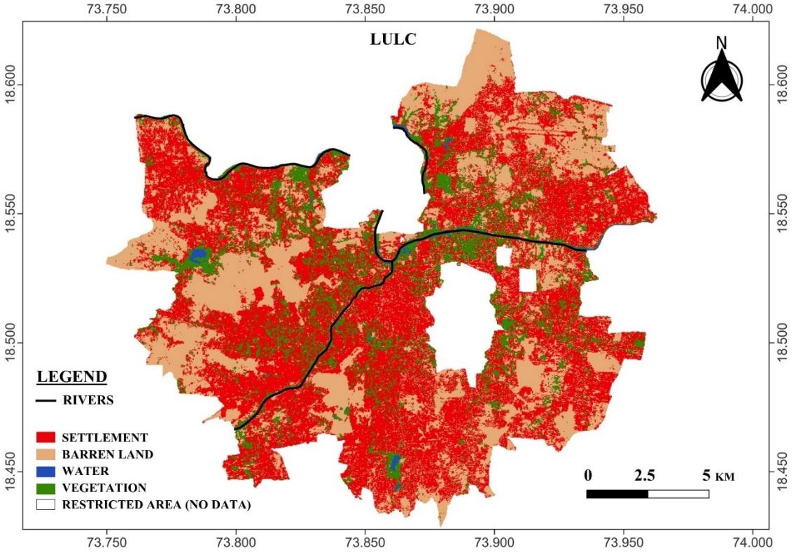
Artificial recharge techniques especially the use of rainwater harvesting (RWH) are being deployed globally to augment supply of fresh water. Ground-water recharge is directly influenced by surface characteristics such as rainfall, geology, soil types, Land Use/Land Cover (LULC), drainage, lineaments/fractures, etc. Hence, six such parameters, namely, LULC, Slope, Soil texture, Rainfall, Drainage density, and Geology were considered to generate a groundwater recharge potential map. Based on the analysis, the study area was zoned into five classes, namely, low, moderate, good, very good and high groundwater potentials. About 45% of the city shows good to high potential for recharge. The results reveal that the high and good potential recharge zones lie to the western part of the city, whereas the central part (inner city) and the eastern part show medium to low potential for recharge. The results can help to identify areas for recharge and formulate a framework for systematic recharge of the existing aquifers in the area under study.
Article Details

This work is licensed under a Creative Commons Attribution-NonCommercial 4.0 International License.
Published articles are under the copyright of the Environment and Natural Resources Journal effective when the article is accepted for publication thus granting Environment and Natural Resources Journal all rights for the work so that both parties may be protected from the consequences of unauthorized use. Partially or totally publication of an article elsewhere is possible only after the consent from the editors.
References
Adham A, Riksen M, Ouessar M, Ritsema CJ. A methodology to assess and evaluate rainwater harvesting techniques in (semi-) arid regions. Water 2016;8(5):1-23.
Akter A, Ahmed S. Potentiality of rainwater harvesting for an urban community in Bangladesh. Journal of Hydrology 2015; 528:84-93.
Benjmel K, Amraoui F, Boutaleb S, Ouchchen M, Tahiri A, Touab A. Mapping of groundwater potential zones in techniques, and multicriteria data analysis (Case of the Ighrem Region, Western Anti-Atlas, Morocco). Water 2020;12: Article No. 471.
Çelik R. Evaluation of groundwater potential by GIS-based multicriteria decision making as a spatial prediction tool: Case study in the Tigris River Batman-Hasankeyf Sub-Basin, Turkey. Water 2019;11:Article No. 12.
Choosumrong S, Raghavan V, Bozon N. Multi-criteria emergency route planning based on analytical hierarchy process and pgRouting. Geoinformatics 2012;23(4):159-67.
Choudhari PP, Nigam GK, Singh SK, Thakur S. Morphometric based prioritization of watershed for groundwater potential of Mula River Basin, Maharashtra, India. Geology, Ecology, and Landscapes 2018;2(4):256-67.
Chowdhury A, Jha MK, Chowdary VM. Delineation of groundwater recharge zones and identification of artificial recharge sites in West Medinipur District, West Bengal, using RS, GIS and MCDM techniques. Environmental Earth Sciences 2010;59:1209-22.
Cornell University. Certified Crop Advisor study resources (Northeast region) [Internet]. 2010 [cited 2022 Jun 22]. Available from: https://nrcca.cals.cornell.edu/soil/CA2/ CA0211.1.php/.
Das B, Pal C. Combination of GIS and fuzzy-AHP for delineating groundwater recharge potential zones in the critical Goghat-II block of West Bengal, India. HydroResearch 2019;2:21-30.
Doke AB, Zolekar AB, Patel H, Das S. Geospatial mapping of groundwater potential zones using multi-criteria decision-making AHP approach in a hardrock basaltic terrain in India. Ecological Indicators 2021;127:Article No. 107685.
Geological Survey of India (GSI). District Resource Map: Pune District, Maharashtra. Publications and Cartography Division, GSI; 2001.
Jamali I, Mörtberg U, Olofsson B, Muhammad S. A spatial multi-criteria analysis approach for locating suitable sites for construction of subsurface dams in Northern Pakistan. Water Resources Management 2014;28(14):5157-74.
Jasrotia AS, Majhi A, Singh S. Water balance approach for rainwater harvesting using remote sensing and GIS techniques, Jammu Himalaya, India. Water Resource Management 2009; 3(14):3035-55.
Kadam AK, Kale SS, Pande NN, Pawar NJ, Sankhua RN. Identifying potential rainwater harvesting sites of a semiarid, Basaltic Region of Western India, using SCS-CN method. Water Resource Management 2012;26:2537-54.
Kadhem GM, Zubari WK. Identifying optimal locations for artificial groundwater recharge by rainfall in the Kingdom of Bahrain. Earth Systems and Environment 2020;4(3):551-66.
Khazaei E, Mackay R, Warner JW. The effects of urbanization on groundwater quantity and quality in the Zahedan Aquifer, Southeast Iran. Water International 2004;29(2):178-88.
Kim SJ, Kwon HJ, Jung IK, Park GA. A comparative study on grid-based storm runoff prediction using Thiessen and spatially distributed rainfall. Paddy Water Environment 2003;1:149-55.
Kulkarni H, Deolankar SB, Lalwani A, Joseph B, Pawar S. Hydrogeological framework for the Deccan basalt ground-water systems, west-central India. Hydrogeology Journal 2000;8(4):368-78.
Kumar VA, Mondal NC, Ahmed S. Identification of groundwater potential zones using RS, GIS and AHP Techniques: A case study in a Part of Deccan Volcanic Province (DVP), Maharashtra, India. Journal of the Indian Society of Remote Sensing 2020;48(3):497-511.
Maity DK, Mandal S. Identification of groundwater potential zones of the Kumari River Basin, India: An RS and GIS based semi-quantitative approach. Environment, Development and Sustainability 2019;21:1013-34.
Mohammed H, Yohannes F, Zeleke G. Validation of agricultural non-point source (AGNPS) pollution model in Kori Watershed, South Wollo, Ethiopia. International Journal of Applied Earth Observation and Geoinformation 2004;6:97-109.
Mondal NC, Ajaykumar V. Assessment of natural groundwater reserve of a morphodynamic system using an information‑ based model in a part of Ganga basin, Northern India. Scientific Reports 2022;12:Article No. 6191.
Nasiri H, Boloorani AD, Sabokbar HAF, Jafari HR, Hamzeh M, Rafii Y. Determining the most suitable areas for artificial groundwater recharge via an integrated PROMETHEE II-AHP method in GIS environment (Case study: Garabaygan Basin, Iran). Environmental Monitoring and Assessment 2013; 185:707-18.
Pai DS, Sridhar L, Rajeevan M, Sreejith OP, Satbhai NS, Mukhopadhyay B. Development of a new high spatial resolution (0.25° × 0.25°) long period (1901-2010) daily gridded rainfall data set over India and its comparison with existing data sets over the region. Mausam 2014;65(1):1-18.
Paul RS, Rawat U, Sengupta D, Biswas A, Tripathi S, Ghosh P. Assessment of groundwater potential zones using multi criteria evaluation technique of Paisuni River Basin from the combined state of Uttar Pradesh and Madhya Pradesh, India. Environmental Earth Sciences 2020;79(340):1-24.
Pune Municipal Corporation. Water budget 2021 [Internet]. 2021 [cited 2022 Jun 3]. Available from: https://pmc.gov.in/sites/ default/files/waterbudget-2021-2022.pdf.
Rajaveni SP, Brindha K, Elango L. Geological and geomorphological controls on groundwater occurrence in a hard rock region. Applied Water Science 2015;7(3):1377-89.
Rangarajan R, Athavale RN. Annual replenishable ground water potential of India: An estimate based on injected tritium studies. Journal of Hydrology 2000(234);38-53.
Rao N. Groundwater potential index in a crystalline terrain using remote sensing data. Environmental Geology 2006;50:1067-76.
Rao N, Gugulothu S, Das R. Deciphering artificial groundwater recharge suitability zones in the agricultural area of a river basin in Andhra Pradesh, India using geospatial techniques and analytical hierarchical process method. Catena 2022; 212:Article No. 106085.
Saaty RW. The analytic hierarchy process: What it is and how it is used. Mathematical Modelling 1987;9(3-5):161-76.
Saaty TL. How to make a decision: The Analytic Hierarchy Process. European Journal of Operational Research 1990; 48:9-26.
Saaty TL. The analytic network process. Iranian Journal of Operations Research 2008;1(5):1-27.
Senanayake IP, Dissanayake DMDOK, Mayadunna BB, Weerasekera WL. An approach to delineate groundwater recharge potential sites in Ambalantota, Sri Lanka using GIS techniques. Geoscience Frontiers 2016;7:115-24.
Shekhar S, Pandey AC. Delineation of groundwater potential zone in hard rock terrain of India using remote sensing, geographical information system (GIS) and analytic hierarchy process (AHP) techniques. Geocarto International 2014; 30(4):402-21.
Singh LK, Jha MK, Chowdary VM. Multi-criteria analysis and GIS modelling for identifying prospective water harvesting and artificial recharge sites for sustainable water supply. Journal of Cleaner Production 2017:142(4):1436-56.
Tiwari RN, Vikash K, Kushwaha VK. An integrated study to delineate the groundwater potential zones using geospatial approach of Sidhi Area, Madhya Pradesh. Journal Geological Society of India 2020;95:520-6.
Vaddadi N, Vansarochana C, Raghavan V. Estimation of groundwater recharge potential using rooftop rainwater harvesting: Case study from Pune Urban Area, India. International Journal of Geoinformatics 2022;18(2):55-69.
Venkatarao AK, Mondal NC, Ahmed S. Investigating ground-water recharge potential zones using a cross‑correlation technique in a part of Deccan Volcanic Province (DVP), Central India. Environmental Earth Sciences 2019;78:Article No. 704.
