Spatial Green Space Assessment in Suburbia: Implications for Urban Development 10.32526/ennrj/22/20230153
Article Sidebar
Main Article Content
Abstract
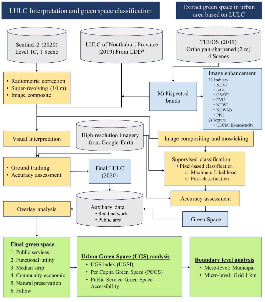
Nonthaburi, a suburban province adjacent to the Bangkok Metropolis, has experienced a reduction in green spaces due to urban expansion. This study quantified Nonthaburi’s green space through visual interpretation of land use and land cover (LULC) using THEOS and Sentinel-2. Areas of green space were extracted using remote sensing indices and pixel-based classification based on THEOS. The extracted green area was then integrated with the existing LULC patterns to align with the green space characteristic established by Thailand’s Office of Natural Resource and Environmental Policy and Planning. This includes public services, functional utility, median strips, community economics, fallow, and natural green space. The analysis of green space management and planning utilized the Urban Green Space Index (UGSI), Per Capita Green Space (PCGS), and accessibility to public green space. The results revealed that Nonthaburi comprises a green space area of 465.29 km2 or 73.06%, exhibiting a higher prevalence within its western region while displaying a relatively lower extent in the urban zone adjacent to the Bangkok Metropolis. The per capita green space is 367.71 m2 but decreases to 255.82 m2 when accounting for the latent population, meaning it still meets the World Health Organization (WHO) criteria. Currently, only six parks (single and clusters) meet the criteria for public green space. Additionally, both fallow and median strip green spaces (at road interchanges) need to be considered for their potential use in new public service. Furthermore, very high-resolution imagery from unmanned aerial vehicles (UAVs) should be used for green space planning by the organization.
Article Details

This work is licensed under a Creative Commons Attribution-NonCommercial 4.0 International License.
Published articles are under the copyright of the Environment and Natural Resources Journal effective when the article is accepted for publication thus granting Environment and Natural Resources Journal all rights for the work so that both parties may be protected from the consequences of unauthorized use. Partially or totally publication of an article elsewhere is possible only after the consent from the editors.
References
Abutaleb K, Mudede MF, Nkongolo N, Newete SW. Estimating urban greenness index using remote sensing data: A case study of an affluent vs poor suburbs in the city of Johannesburg. Egyptian Journal of Remote Sensing and Space Sciences 2021;24(3):343-51.
Adorno BV, Körting TS, Amaral S. Contribution of time-series data cubes to classify urban vegetation types by remote sensing. Urban Forestry and Urban Greening 2023;79:Article No. 127817.
Alavipanah S, Wegmann M, Qureshi S, Weng Q, Koellner T. The role of vegetation in mitigating urban land surface temperatures: A case study of Munich, Germany during the warm season. Sustainability 2015;7(4):4689-706.
Alcaras E, Falchi U, Parente C, Vallario A. Accuracy evaluation for coastline extraction from Pléiades imagery based on NDWI and IHS pan-sharpening application. Applied Geomatics 2022;15(3):595-605.
Bastian O, Haase D, Grunewald K. Ecosystem properties, potentials, and services: The EPPS conceptual framework and an urban application example. Ecological Indicators 2012;21:7-16.
Bondarenko M, Kerr D, Sorichetta A, Tatem AJ. Census/Projection-Disaggregated Gridded Population Datasets, Adjusted to Match the Corresponding UNPD 2020 Estimates, for 183 Countries in 2020 Using Built-Settlement Growth Model (BSGM) Outputs. Hampshire: University of Southampton; 2020.
Brodu N. Super-resolving multiresolution images with band-independent geometry of multispectral pixels. IEEE Transactions on Geoscience and Remote Sensing 2017; 55(8):4610-7.
Campbell JB. Introduction to Remote Sensing. New York: The Guilford Press; 1987.
Carbó-Ramírez P, Zuria I. The value of small urban greenspaces for birds in a Mexican city. Landscape and Urban Planning 2011;100(3):213-22.
Chinnabut S, Chen N, Zhang H. Analysis urban green space classification using landscape pattern analysis based on GIS and remote sensing in Pattaya, Thailand. Proceeding of the 2nd Intercontinental Geoinformation Days (IGD); 2021 May 5-6; Mersin: Turkey; 2021.
Chitchang K, Cheyklinput K. Impact on green areas in Sao Thong Hin Sub-District and Bang Mae Nang Sub-district, Bang Yai District due to the expansion of Nonthaburi Province Between 1982 and 2021. Journal of Social Sciences and Humanities 2022;48(2):73-92 (in Thai).
Congalton RG, Green K. Assessing the Accuracy of Remotely Sensed Data: Principles and Practices. Washington DC: CRC Press; 1999.
Congalton RG. A review of assessing the accuracy of classifications of remotely sensed data. Remote Sensing of Environment 1991;37(1):35-46.
Corley J, Okely J, Taylor AM, Page DC, Welstead M, Skarabela B, et al. Home garden use during COVID-19: Associations with physical and mental wellbeing in older adults. Journal of Environmental Psychology 2021;73:Article No. 101545.
de Sousa Silva C, Viegas I, Panagopoulos T, Bell S. Environmental justice in accessibility to green infrastructure in two European Cities. Land 2018;7(4):Article No. 134.
Deloya MC. Urban forestry activities in Mexico. Unasylva 1993;173(44):28-32.
Department of Provincial Administration. Population number [Internet]. 2019 [cited 2020 Jun 24]. Available from: https://stat.bora.dopa.go.th/new_stat/webPage/statByYear.php (in Thai).
European Space Agency (ESA). Sentinel-2 User Handbook [Internet]. 2015 [cited 2021 Aug 30]. Available from: https://sentinel.esa.int/documents/247904/685211/Sentinel-2_User_Handbook.
Fitpatricks-Lins K. Comparison of sampling procedures and data analysis for a land-use and land-cover map. Photogrammetric Engineering and Remote Sensing 1981;47(3):343-51.
Ghorbanian A, Kakooei M, Amani M, Mahdavi S, Mohammadzadeh A, Hasanlou M. Improved land cover map of Iran using Sentinel imagery within Google Earth Engine and a novel automatic workflow for land cover classification using migrated training samples. ISPRS Journal of Photogrammetry and Remote Sensing 2020;167:276-88.
Haq S. Urban green spaces and an integrative approach to sustainable environment. Journal of Environmental Protection 2011;2(5):601-8.
Haralick RM, Shanmugan K, Dinstein I. Textural Features for Image Classification. IEEE Transactions on Systems, Man, and Cybernetics 1973;3(6):610-21.
Heinze J. Benefits of Green Space - Recent Research. Virginia: Environmental Health Research Foundation; 2011.
Huete AR. A soil-adjusted vegetation index (SAVI). Remote Sensing of Environment 1988;25(3):295-309.
Jiang Z, Huete AR, Didan K, Miura T. Development of a two-band enhanced vegetation index without a blue band. Remote Sensing of Environment 2008;112(10):3833-45.
Jin Y, Xu Y, Liu W. The green quality of urban spatial development: A multi-dimensional and multi-regional model using big data. Urban Forestry and Urban Greening 2023;85:Article No. 127953.
Kalawong S, Chainit A, Bongsebodhidhamma N. Local government collaboration model development in local development plan collaboration in Nonthaburi Province, Thailand. Asian Political Science Review 2018;2(2):60-71.
Krefis AC, Schwarz NG, Nkrumah B, Acquah S, Loag W, Oldeland J, et al. Spatial analysis of land cover determinants of malaria incidence in the Ashanti Region, Ghana. PloS ONE 2011;6(3):e17905.
Krisdianto, Soekarno, Udiansyah, Januwiadi B. Standing carbon in an urban green space and its contribution to the reduction of the thermal discomfort index: A case study in the City of Banjarbaru, Indonesia. International Journal of Scientific and Research Publications 2012;2(4):1-7.
Kruasilp J, Pattanakiat S, Phutthai T, Vardhanabindu P, Nakmuenwai P. Evaluation of land use land cover changes in Nan Province, Thailand, using multi-sensor satellite data and Google Earth Engine. Environment and Natural Resources Journal 2023;21(2):186-97.
Kuchelmeister G. Urban green for local needs - improving quality of life through multipurpose urban forestry in developing countries. Proceedings of the 1st International Conference on Quality of Life in Cities; 1998 Mar 4-6; Singapore; 1998.
Lachowycz K, Jones AP. Towards a better understanding of the relationship between greenspace and health: Development of a theoretical framework. Landscape and Urban Planning 2013;118:62-9.
Landis JR, Koch GG. The measurement of observer agreement for categorical data. Biometrics 1977;33:159-74.
Lane C, Liu H, Autrey B, Anenkhonov O, Chepinoga V, Wu Q. Improved wetland classification using eight-band high resolution satellite imagery and a hybrid approach. Remote Sensing 2014;6(12):12187-216.
Li G, Lu D, Moran E, Hetrick S. Land-cover classification in a moist tropical region of Brazil with Landsat TM imagery. International Journal of Remote Sensing 2011;32(23):8207-30.
Lin D, Sun Y, Yang Y, Han Y, Xu C. Urban park use and self-reported physical, mental, and social health during the COVID-19 pandemic: An on-site survey in Beijing, China. Urban Forestry and Urban Greening 2023;79:Article No. 127804.
Lu C, Wu Y, Shen Q, Wang H. Driving force of urban growth and regional planning: A case study of China, Guangdong Province. Habitat International 2013;40:35-41.
McFeeters SK. The use of Normalized Difference Water Index (NDWI) in the delineation of open water features. International Journal of Remote Sensing 1996;17(7):1425-32.
Nathalang S. From the suburb communities to capitalist urbanism: The case study of Nonthaburi Area. Journal of Anthropology, Sirindhorn Anthropology Centre 2019;1(2):150-90.
National Economic and Social Development Council (NESDC). The Twelfth National Economic and Social Development Plan (2017-2021). Bangkok, Thailand: NESDC; 2017.
Nawar N, Sorker R, Chowdhury FJ, Rahman M. Present status and historical changes of urban green space in Dhaka City, Bangladesh: A remote sensing driven approach. Environmental Challenges 2022;6:Article No. 100425.
Nonthaburi Provincial Office. The Fifth Years Nonthaburi Development Plan (2018-2022). Nonthaburi, Thailand: Nonthaburi Provincial Office; 2019 (in Thai).
Nonthaburi Provincial Statistical Office. Nonthaburi Provincial Statistical Report: 2020. Bangkok, Thailand: National Statistical Office, Ministry of Digital Economy and Society; 2020 (in Thai).
Nor ANM, Aziz HA, Nawawi SA, Jamil RM, Abas MA, Hambali K, et al. Evolution of green space under rapid urban expansion in Southeast Asian Cities. Sustainability 2021;13(21):Article No. 12024.
Government Gazette. Notification of the Ministry of Interior Re: the enforcement of Town Planning of Nonthaburi 2023. Volume 140, Part 48 D, Dated 1 March B.E. 2566. Bangkok, Thailand: Office of the Council of State; 2023 (in Thai).
Nowak DJ, Rowntree RA, McPherson EG, Sisinni SM, Kerkmann ER, Stevens JC. Measuring and analyzing urban tree cover. Landscape and Urban Planning 1996;36(1):49-57.
Oh K, Jeong S. Assessing the spatial distribution of urban parks using GIS. Landscape Urban Plan 2007;82(1-2):25-32.
Office of Natural Resource and Environmental Policy and Planning (ONEP). Driving Sustainable Green Space Guideline. Bangkok, Thailand: ONEP; 2019 (in Thai).
Office of Natural Resource and Environmental Policy and Planning (ONEP). Management Guideline and Standard for Urban Green Space in Thailand. Bangkok, Thailand: Thailand Environment Institute (TEI); 2017 (in Thai).
Pan L, Lu L, Fu P, Nitivattananon V, Guo H, Li Q. Understanding spatiotemporal evolution of the surface urban heat island in the Bangkok metropolitan region from 2000 to 2020 using enhanced land surface temperature. Geomatics, Natural Hazards and Risk 2023;14(1):Article No. 2174904.
Park Y, Guldmann J. Understanding disparities in community green accessibility under alternative green measures: A metropolitan-wide analysis of Columbus, Ohio, and Atlanta, Georgia. Landscape and Urban Planning 2020;200:Article No. 103806.
Petersen LK. The materiality of everyday practices in urban greenspace. Journal of Environmental Policy and Planning 2013;15(3):353-70.
Pinto LV, Inácio M, Ferreira CS, Ferreira AD, Pereira P. Ecosystem Services and well-being dimensions related to urban green spaces: A systematic review. Sustainable Cities and Society 2022;85:Article No. 104072.
Pouso S, Borja Á, Fleming LE, Gómez-Baggethun E, White MP, Uyarra MC. Contact with blue-green spaces during the COVID-19 pandemic lockdown beneficial for mental health. Science of the Total Environment 2021;756:Article No. 143984.
Qu L, Chen Z, Li M, Zhi J, Wang H. Accuracy improvements to pixel-based and object-based LULC classification with auxiliary datasets from Google Earth Engine. Remote Sensing 2021;13(3):Article No. 453.
Qu W, Lu JX, Li L, Li XW. Research on automatic extraction of water bodies and wetlands on HJ Satellite CCD images. Remote Sensing Information 2011;4:28-33.
Richards DR, Passy P, Oh RRY. Impacts of population density and wealth on the quantity and structure of urban green space in tropical Southeast Asia. Landscape and Urban Planning 2017;157:553-60.
Rondeaux G, Steven M, Baret F. Optimization of soil-adjusted vegetation indices. Remote Sensing of Environment 1996; 55(2):95-107.
Rouse JW, Haas RH, Schell JA, Deering DW. Monitoring Vegetation Systems in the Great Plains with ERTS. Proceedings of the Third ERTS Symposium, NASA SP-351; 1973 Dec 10-14; Washington DC; 1973. p. 309-17.
Russo A, Cirella GT. Modern compact cities: How much greenery do we need? International Journal of Environmental Research and Public Health 2018;15(10):Article No. 2180.
Sakulcharoenporn S, Kiattisahakul P. Nonthaburi Province expansion of housing estates, 1982-1994. Journal of the Faculty of Arts, Silpakorn University 2021;43(1):133-54 (in Thai).
Sangpradid S, Sarapirome S. Road extraction from pan-sharpened THEOS images. Journal of Remote Sensing and GIS Association of Thailand 2014;15(2):12-7.
Sathyakumar V, Ramsankaran R, Bardhan R. Geospatial approach for assessing spatiotemporal dynamics of urban green space distribution among neighbourhoods: A demonstration in Mumbai. Urban Forestry and Urban Greening 2020;48:Article No. 126585.
Senanayake IP, Welivitiya WDDP, Nadeeka PM. Urban green spaces analysis for development planning in Colombo, Sri Lanka, utilizing THEOS satellite imagery: A remote sensing and GIS approach. Urban Forestry and Urban Greening 2013;12(3):307-14.
Shahfahad, Kumari B, Tayyab M, Hang HT, Khan MM, Rahman A. Assessment of public open spaces (POS) and landscape quality based on per capita POS index in Delhi, India. SN Applied Sciences 2019;1:Article No. 368.
Shahtahmassebi AR, Li C, Fan Y, Wu Y, Lin Y, Gan M, et al. Remote sensing of urban green spaces: A review. Urban Forestry and Urban Greening 2021;57:Article No. 126946.
Shekhar S, Aryal J. Role of geospatial technology in understanding urban green space of Kalaburagi City for sustainable planning. Urban Forestry and Urban Greening 2019;46:Article No. 126450.
Song Y, Aryal J, Tan L, Jin L, Gao Z, Wang Y. Comparison of changes in vegetation and land cover types between Shenzhen and Bangkok. Land Degradation and Development 2021;32(3):1192-204.
Suthasupa S. Open space: Elements in the city plan. NAJUA: Architecture, Design and Built Environment 1997;15:121-8 (in Thai).
Taylor L, Hochuli DF. Defining greenspace: Multiple uses across multiple disciplines. Landscape and Urban Planning 2017; 158:25-38.
Thaiutsa B, Puangchit L, Kjelgren R, Arunpraparut W. Urban green space, street tree and heritage large tree assessment in Bangkok, Thailand. Urban Forestry and Urban Greening 2008;7(3):219-29.
Thakkar A, Desaic V, Patel A, Potdar M. Land use/land cover classification using remote sensing data and derived indices in a heterogeneous landscape of a Khan-Kali watershed, Gujarat. Asian Journal of Geoinformatics 2014;14(4):1-12.
Thongdara R, Tanachaikhan P, Kulpradit K, Tibkaew PA. The urban expansion to durian orchard in Nonthaburi. Proceedings of the 34th Asian Conference on Remote Sensing 2013; 2013 Oct 20-24; Bali: Indonesia; 2013.
Tian Y, Chen H, Song Q, Zheng K. A novel index for impervious surface area mapping: Development and validation. Remote Sensing 2018;10:Article No. 1521.
United States Environmental Protection Agency (US EPA). What is open space/green space [Internet]. 2017 [cited 2021 Aug 24]. Available from: https://www3.epa.gov/region1/eco/uep/ openspace.html.
Vigneshwaran S, Kumar SV. Comparison of classification methods for urban green space extraction using very high resolution worldview-3 imagery. Geocarto International 2021;36(13):1429-42.
Vîlcea C, Șoșea C. A GIS-based analysis of the urban green space accessibility in Craiova City, Romania. Geografisk Tidsskrift-Danish Journal of Geography 2020;120(1):19-34.
White MP, Alcock I, Wheeler BW, Depledge MH. Coastal proximity, health, and well-being: Results from a longitudinal panel survey. Health and Place 2013;23:97-103.
Wirayuda IKAK, Widayani P, Sekaranom AB. Urban green space analysis and its effect on the surface urban heat island phenomenon in Denpasar City, Bali. Forest and Society 2023;7(1):150-68.
WHO Regional Office for Europe. Urban Green Spaces: A Brief for Action. Copenhagen: WHO Regional Office for Europe, Copenhagen; 2017.
World Health Organization (WHO). Health Indicators of sustainable cities in the Context of the Rio+20 UN Conference on Sustainable Development [Internet]. 2012 [cited 2021 Aug 24]. Available from: https://cdn.who.int/media/docs/default-source/environment-climate-change-and-health/sustainable-development-indicator-cities.pdf?sfvrsn=c005156b_2.
World Health Organization (WHO). Urban Planning, Environment and Health: From Evidence to Policy Action. Geneva: World Health Organization; 2010. p. 119.
Xu G, Jiao L, Liu J, Shi Z, Zeng C, Liu Y. Understanding urban expansion combining macro patterns and micro dynamics in three Southeast Asian megacities. Science of the Total Environment 2019;660:375-83.
Zhao M, Zhou Y, Li X, Cheng W, Zhou C, Ma T, et al. Mapping Urban Dynamics (1992-2018) in Southeast Asia using consistent nighttime light data from DMSP and Viirs. Remote Sensing of Environment 2020;248:Article No. 111980.
