Monitoring Land Surface Temperature Relationship to Land Use and Land Cover in Hai Duong Province, Vietnam 10.32526/ennrj/22/20230194
Article Sidebar
Main Article Content
Abstract
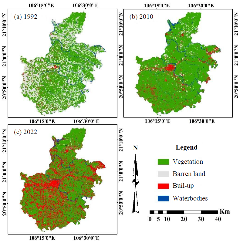
This study utilised remote sensing data and ArcGIS 10.8 software to evaluate changes in land use and land cover (LULC) and their effects on land surface temperature (LST) in Hai Duong Province, Vietnam, from 1992 to 2022. Landsat satellite data were pre-processed and classified using supervised methods for the years 1992, 2010, and 2022. In 1992, vegetation cover accounted for 57.89% of land cover, increasing to 84.49% in 2010, but then decreasing again to 66.67% in 2022. In contrast, the built-up area consistently increased, from 2.88% in 1992 to 29.35% in 2022, as most of the barren land present in 1992 became built-up area in 2022. The LST values were calculated from the thermal bands for the years 1992, 2010, and 2022 and ranged from 16.09°C to 34.27°C, 17.04°C to 36.74°C, and 11.03°C to 28.44°C, respectively. In addition, the Normalized Difference Vegetation Index (NDVI) values were calculated using the near-infrared band and the red band, with values ranging from -0.40 to 0.70 over the study period. A linear regression analysis indicated a shift in the correlation between NDVI and LST from positive to negative. This study highlights the significant transformation that occurred in Hai Duong Province due to rapid population density increases, urban growth and infrastructure development, leading to a decline in greenery. These LULC changes can cause severe environmental damage. These research findings will assist policymakers in formulating management strategies and sustainable land-use plans to minimize potential harm and promote sustainable development in the area.
Article Details

This work is licensed under a Creative Commons Attribution-NonCommercial 4.0 International License.
Published articles are under the copyright of the Environment and Natural Resources Journal effective when the article is accepted for publication thus granting Environment and Natural Resources Journal all rights for the work so that both parties may be protected from the consequences of unauthorized use. Partially or totally publication of an article elsewhere is possible only after the consent from the editors.
References
Ahmad F, Ghazi S, Ahmad SR, Ahmad I, Khan RMA, Raoof A, et al. Spectral characteristics and mapping of rice fields using multi-temporal landsat and MODIS data: A case of District Narowal. Global Journal of Human-Social Science Research 2014;14(6):Article No. 2.
Ahmed J, Ahmed M, Laghari A, Lohana W, Ali S, Fatmi Z. Public private mix model in enhancing tuberculosis case detection in District Thatta, Sindh, Pakistan. Journal of the Pakistan Medical Association 2009;59(2):Article No. 82.
Alam HE, Arafat MdY, Ahmed KT, Uddin MN. Temporal variation of land surface temperature in response to changes in vegetation index of Bhawal National Park, Bangladesh. In: Pal I, Kolathayar S, editors. Sustainable Cities and Resilience. Singapore: Lecture Notes in Civil Engineering Springer Singapore; 2022. p. 329-37.
Alganci U, Soydas M, Sertel E. Comparative research on deep learning approaches for airplane detection from very high-resolution satellite images. Remote Sensing 2020;12(3): Article No. 458.
Balew A, Korme T. Monitoring land surface temperature in Bahir Dar City and its surrounding using landsat images. The Egyptian Journal of Remote Sensing and Space Science 2020;23(3):371-86.
Bohanon A, Crane K. Structural and biological analysis of faults in basalts in Sheepshead Mountains, Oregon as an earth analogue to mars. Icarus 2022;385:Article No. 115121.
Celik S. The effects of climate change on human behaviors. In: Fahad S, Hasanuzzaman M, Alam M, Ullah H, Saeed M, Khan IA, et al. editors. Environment, Climate, Plant and Vegetation Growth. Cham: Springer International Publishing; 2020; p. 577-89.
Chamling M, Bera B. Spatio-temporal patterns of land use/land cover change in the Bhutan-Bengal Foothill region between 1987 and 2019: Study towards geospatial applications and policy making. Earth Systems and Environment 2020;4(1): 117-30.
Cvitić I, Peraković D, Periša M, Gupta B. Ensemble machine learning approach for classification of IoT devices in smart home. International Journal of Machine Learning and Cybernetics 2021;12(11):3179-202.
Das M, Das A. Dynamics of urbanization and its impact on urban ecosystem services (UESs): A study of a medium size town of West Bengal, Eastern India. Journal of Urban Management 2019;8(3):420-34.
Donelson JM, Salinas S, Munday PL, Shama LN. Transgenerational plasticity and climate change experiments: Where do we go from here? Global Change Biology 2018;24(1):13-34.
Estrella EH, Stoeth A, Krakauer NY, Devineni N. Quantifying vegetation response to environmental changes on the Galapagos Islands, Ecuador using the normalized difference vegetation index (NDVI). Environmental Research Communications 2021;3(6):Article No. 065003.
Fatemi M, Narangifard M. Monitoring LULC changes and its impact on the LST and NDVI in district 1 of Shiraz City. Arabian Journal of Geosciences 2019;12(4):Article No. 127.
Fayaz A, Shafiq MU, Singh H, Ahmed P. Assessment of spatiotemporal changes in land use/land cover of North Kashmir Himalayas from 1992 to 2018. Modeling Earth Systems and Environment 2020;6(2):1189-200.
Fayech D, Tarhouni J. Climate variability and its effect on normalized difference vegetation index (NDVI) using remote sensing in semi-arid area. Modeling Earth Systems and Environment 2021;7(3):1667-82.
Feizizadeh B, Darabi S, Blaschke T, Lakes T. QADI as a new method and alternative to Kappa for accuracy assessment of remote sensing-based image classification. Sensors 2022; 22(12):Article No. 4506.
General Statistics Office. Statistical yearbook of Viet Nam. Statistical publishing house [Internet]. 2022 [cited 2023 Jul 10]. Available from: https://www.gso.gov.vn/wp-content/ uploads/2023/06/Sach-Nien-giam-TK-2022-update-21.7_file-nen-Water.pdf.
Guha S. Dynamic seasonal analysis on LST-NDVI relationship and ecological health of Raipur City, India. Ecosystem Health and Sustainability 2021;7(1):Article No. 1927852.
Hai Duong Statistical Office. Report: Socio-economic situation in December and the whole year of 2022, Hai Duong province [Internet]. 2022 [cited 2023 Jul 10]. Available from: https://web01.haiduong.gov.vn/Lists/TinTuc/Attachments/14460/BC%20KTXH%20T12.2022%20tinh%20Hai%20Duong.pdf.
Hammad HM, Ashraf M, Abbas F, Bakhat HF, Qaisrani SA, Mubeen M, et al. Environmental factors affecting the frequency of road traffic accidents: A case study of sub-urban area of Pakistan. Environmental Science and Pollution Research 2019;26(12):11674-85.
Hu Y, Raza A, Syed NR, Acharki S, Ray RL, Hussain S, et al. Land use/land cover change detection and NDVI estimation in Pakistan’s Southern Punjab Province. Sustainability 2023; 15(4):Article No. 3572.
Hussain S, Karuppannan S. Land use/land cover changes and their impact on land surface temperature using remote sensing technique in District Khanewal, Punjab Pakistan. Geology, Ecology, and Landscapes 2023;7(1):46-58.
Hussain S, Mubeen M, Ahmad A, Akram W, Hammad HM, Ali M, et al. Using GIS tools to detect the land use/land cover changes during forty years in Lodhran District of Pakistan. Environmental Science and Pollution Research 2020;27 (32):39676-92.
Kumar S, Arya S, Jain K. A SWIR-based vegetation index for change detection in land cover using multi-temporal landsat satellite dataset. International Journal of Information Technology 2022;14(4):2035-48.
Laux P, Nguyen PNB, Cullmann J, Kunstmann H. Impacts of land-use/land-cover change and climate change on the regional climate in the Central Vietnam. In: Nauditt A, Ribbe L. editors. Land Use and Climate Change Interactions in Central Vietnam: Water Resources Development and Management. Singapore: Springer Singapore; 2017. p. 143-51.
Li C, Wu Y, Gao B, Zheng K, Wu Y, Li C. Multi-scenario simulation of ecosystem service value for optimization of land use in the sichuan-yunnan ecological barrier, China. Ecological Indicators 2021;132:Article No. 108328.
Mahmoud SH, Gan TY. Impact of anthropogenic climate change and human activities on environment and ecosystem services in arid regions. Science of the Total Environment 2018; 633:1329-44.
Moazzam MFU, Doh YH, Lee BG. Impact of urbanization on land surface temperature and surface urban heat island using optical remote sensing data: A case study of Jeju Island, Republic of Korea. Building and Environment 2022;222:Article No. 109368.
Monroe MC, Plate RR, Oxarart A, Bowers A, Chaves WA. Identifying effective climate change education strategies: A systematic review of the research. Environmental Education Research 2019;25(6):791-812.
Mubeen M, Bano A, Ali B, Islam ZU, Ahmad A, Hussain S, et al. Effect of plant growth promoting bacteria and drought on spring maize (Zea Mays L.). Pakistan Journal of Botany 2021;53(2):731-9.
Mukherjee F, Singh D. Assessing land use-land cover change and its impact on land surface temperature using LANDSAT data: A comparison of two urban areas in India. Earth Systems and Environment 2020;4(2):385-407.
Nguyen TM, Lin TH, Chan HP. The environmental effects of urban development in Hanoi, Vietnam from satellite and meteorological observations from 1999-2016. Sustainability 2019;11(6):Article No. 1768.
Nse OU, Okolie CJ, Nse VO. Dynamics of land cover, land surface temperature and NDVI in Uyo City, Nigeria. Scientific African 2020;10:e00599.
Owolabi ST, Madi K, Kalumba AM, Orimoloye IR. A groundwater potential zone mapping approach for semi-arid environments using remote sensing (RS), geographic information System (GIS), and Analytical Hierarchical Process (AHP) techniques: A case study of buffalo catchment, Eastern Cape, South Africa. Arabian Journal of Geosciences 2020;13(22):Article No. 1184.
Phuong VT, Thien BB. A multi-temporal landsat data analysis for land-use/land-cover change in the Northwest Mountains Region of Vietnam Using Remote Sensing Techniques. Forum Geografic 2023a;22(1):54-66.
Phuong VT, Thien BB. Using landsat satellite images to detect forest cover changes in the Northeast Region of Vietnam. Bulletin of the Transilvania University of Brasov Series II: Forestry Wood Industry Agricultural Food Engineering 2023b;16(1):19-36.
Praveen B, Sharma P. A review of literature on climate change and its impacts on agriculture productivity. Journal of Public Affairs 2019;19(4):e1960.
Rahaman ZA, Kafy AA, Faisal AA, Al Rakib A, Jahir DMA, Fattah MA, et al. Predicting microscale land use/land cover changes using cellular automata algorithm on the Northwest Coast of Peninsular Malaysia. Earth Systems and Environment 2022;6(4):817-35.
Rendana M, Razi Idris WM, Abdul Rahim S, Ghassan Abdo H, Almohamad H, Abdullah Al Dughairi A, et al. Effects of the built-up index and land surface temperature on the mangrove area change along the Southern Sumatra Coast. Forest Science and Technology 2023;19(3):179-89.
Ritse V, Basumatary H, Kulnu AS, Dutta G, Phukan MM, Hazarika N. Monitoring land use land cover changes in the Eastern Himalayan Landscape of Nagaland, Northeast India. Environmental Monitoring and Assessment 2020;192(11): Article No. 711.
Rizvi SH, Fatima H, Alam K, Iqbal MJ. The surface urban heat island intensity and urban expansion: A comparative analysis for the Coastal Areas of Pakistan. Environment, Development and Sustainability 2021;23(4):5520-37.
Roberts C, Geels FW, Lockwood M, Newell P, Schmitz H, Turnheim B, et al. The politics of accelerating low-carbon transitions: Towards a new research agenda. Energy Research and Social Science 2018;44:304-11.
Sadiq Khan M, Ullah S, Sun T, Rehman AU, Chen L. Land-use/land-cover changes and its contribution to urban heat island: A case study of Islamabad, Pakistan. Sustainability 2020;12(9):Article No. 3861.
Sahin G, Cabuk SN, Cetin M. The change detection in coastal settlements using image processing techniques: A case study of Korfez. Environmental Science and Pollution Research 2022;29(10):15172-87.
Sajan B, Kanga S, Singh SK, Mishra VN, Durin B. Spatial variations of LST and NDVI in Muzaffarpur District, Bihar using google earth engine (GEE) during 1990-2020. Journal of Agrometeorology 2023;25(2):262-7.
Sekertekin A, Bonafoni S. Sensitivity analysis and validation of daytime and nighttime land surface temperature retrievals from landsat 8 using different algorithms and emissivity models. Remote Sensing 2020;12(17):Article No. 2776.
Silva JS, da Silva RM, Santos CAG. Spatiotemporal impact of land use/land cover changes on urban heat islands: A case study of Paço Do Lumiar, Brazil. Building and Environment 2018;136:279-92.
Skendžić S, Zovko M, Živković IP, Lešić V, Lemić D. The impact of climate change on agricultural insect pests. Insects 2021;12(5):Article No. 440.
Son NT, Chen CF, Chen CR, Thanh BX, Vuong TH. Assessment of urbanization and urban heat islands in Ho Chi Minh City, Vietnam using landsat data. Sustainable Cities and Society 2017;30:150-61.
Tang J, Di L. Past and future trajectories of farmland loss due to rapid urbanization using landsat imagery and the markov-CA model: A case study of Delhi, India. Remote Sensing 2019;11(2):Article No. 180.
Thanh Hoan N, Liou YA, Nguyen KA, Sharma RC, Tran DP, Liou CL, et al. Assessing the effects of land-use types in surface urban heat islands for developing comfortable living in Hanoi City. Remote Sensing 2018;10(12):Article No. 1965.
Thien BB, Phuong VT. Using landsat satellite imagery for assessment and monitoring of long-term forest cover changes in Dak Nong Province, Vietnam. Geographica Pannonica 2023;27(1):69-82.
Thien BB, Phuong VT, Komolafe AA. Assessment of forest cover and forest loss using satellite images in Thua Thien Hue Province, Vietnam. AUC Geographica 2023a;58(2):172-86.
Thien BB, Yachongtou B, Phuong VT. Long-term monitoring of forest cover change resulting in forest loss in the capital of Luang Prabang Province, Lao PDR. Environmental Monitoring and Assessment 2023b;195(8):Article No. 947.
Veettil BK, Puri V, Van DD, Quang NX. Variations in land surface temperatures in small-scale urban areas in Vietnam during Covid-19 restrictions: Case studies from Da Nang, Hue and Vinh City. Environmental Monitoring and Assessment 2023;195(7):Article No. 822.
Veettil BK, Van DD. Did the Covid-19 restrictions influence land surface temperatures in Southeast Asia? A study from Ho Chi Minh City, Vietnam. Environmental Science and Pollution Research 2023;30(25):66812-21.
Viana CM, Girão I, Rocha J. Long-term satellite image time-series for land use/land cover change detection using refined open source data in a rural region. Remote Sensing 2019;11(9): Article No. 1104.
Winsemius HC, Jongman B, Veldkamp TI, Hallegatte S, Bangalore M, Ward PJ. Disaster risk, climate change, and poverty: Assessing the global exposure of poor people to floods and droughts. Environment and Development Economics 2018;23(3):328-48.
Workie TG, Debella HJ. Climate change and its effects on vegetation phenology across ecoregions of ethiopia. Global Ecology and Conservation 2018;13:e00366.
Xu L, Jing W, Song H, Chen G. High-resolution remote sensing image change detection combined with pixel-level and object-level. IEEE Access 2019;7:78909-18.
Yao N, Huang C, Yang J, Konijnendijk van den Bosch CC, Ma L, Jia Z. Combined effects of impervious surface change and large-scale afforestation on the surface urban heat island intensity of Beijing, China based on remote sensing analysis. Remote Sensing 2020;12(23):Article No. 3906.
Zamin M, Khattak AM, Salim AM, Marcum KB, Shakur M, Shah S, et al. Performance of aeluropus lagopoides (mangrove grass) ecotypes, a potential turfgrass, under high saline conditions. Environmental Science and Pollution Research 2019;26(13):13410-21.
Zeng Y, Badgley G, Dechant B, Ryu Y, Chen M, Berry JA. A practical approach for estimating the escape ratio of near-infrared solar-induced chlorophyll fluorescence. Remote Sensing of Environment 2019;232:Article No. 111209.
Zeren Cetin I, Varol T, Ozel HB. A geographic information systems and remote sensing-based approach to assess urban micro-climate change and its impact on human health in Bartin, Turkey. Environmental Monitoring and Assessment 2023;195(5):Article No. 540.
Zhang X, Zhou J, Göttsche F-M, Zhan W, Liu S, Cao R. A method based on temporal component decomposition for estimating 1-Km all-weather land surface temperature by merging satellite thermal infrared and passive microwave observations. IEEE Transactions on Geoscience and Remote Sensing 2019;57(7):4670-91.
Zia Z, Bakhat HF, Saqib ZA, Shah GM, Fahad S, Ashraf MR, et al. Effect of water management and silicon on germination, growth, phosphorus and arsenic uptake in rice. Ecotoxicology and Environmental Safety 2017;144:11-8.
