Assessing Spatial-Temporal Patterns of Agricultural Drought Vulnerability and Its Impacts on Economic Crops, Nakhon Ratchasima, Thailand 10.32526/ennrj/23/20240304
Article Sidebar
Main Article Content
Abstract
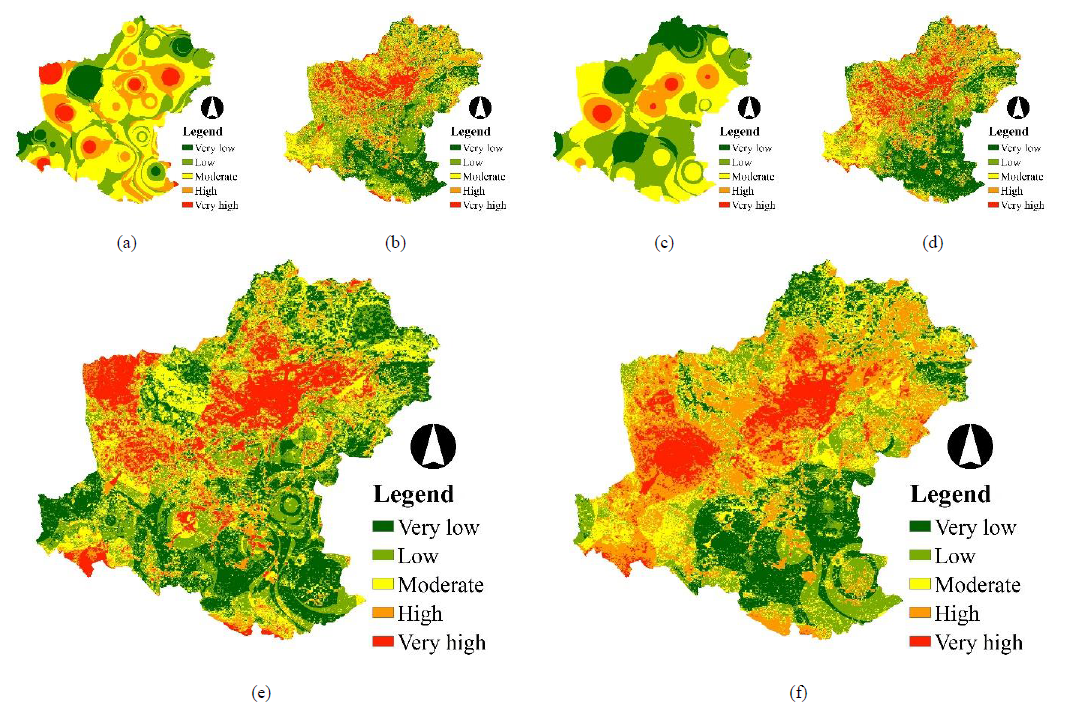
Thailand frequently suffers from rainfall shortages and ensuing droughts and the northeast region is especially vulnerable. The effects of climate change on water resources are further directly related to agricultural drought vulnerability. The objectives of the study were (1) to assess the spatial and temporal patterns of agricultural drought vulnerability based on agricultural drought exposure, agricultural drought sensitivity, and adaptive capacity and (2) to assess the potential impact of agricultural drought vulnerability on economic crops. To do so, this study integrated drought exposure, drought sensitivity and adaptive capacity for assessing spatial and temporal patterns of agricultural drought vulnerability and their potential impacts on economic crops at both the district and subdistrict levels in Thailand’s northeastern Nakhon Ratchasima Province. Our results showed that the spatial and temporal patterns of agricultural drought vulnerability in two periods (6m10 and 12m) varied from one region to another. Levels of severity were established, and moderate, high and very high levels were found in 10 districts and 96 subdistricts in the 6m10 period (May to October). They further occurred in 17 districts and 166 subdistricts in the 12m period (January to December). Districts and subdistricts with identical potential impact in both periods included 3 districts and 48 subdistricts. The potential impact of agricultural drought vulnerability on economic crops further was higher in the 12m duration than for 6m10. The highest potential impact was found to be on cassava (2023). In conclusion, the results of the study can be used as basic information for government agencies to monitor and mitigate agricultural drought in Nakhon Ratchasima. The government should further consider implementing a feasibility study for groundwater use in local agriculture, to better mitigate the impact of drought on important vulnerable economic crops.
Article Details

This work is licensed under a Creative Commons Attribution-NonCommercial 4.0 International License.
Published articles are under the copyright of the Environment and Natural Resources Journal effective when the article is accepted for publication thus granting Environment and Natural Resources Journal all rights for the work so that both parties may be protected from the consequences of unauthorized use. Partially or totally publication of an article elsewhere is possible only after the consent from the editors.
References
Antwi-Agyei P, Fraser ED, Dougill AJ, Stringer LC, Simelton E. Mapping the vulnerability of crop production to drought in Ghana using rainfall, yield and socio-economic data. Applied Geography 2012;32(2):324-34.
Begum RA, Lempert R, Ali E, Benjaminsen TA, Bernauer T, Cramer W, et al. Climate Change 2022: Impacts, Adaptation and Vulnerability. Contribution of Working Group II to the Sixth Assessment Report of the Intergovernmental Panel on Climate Change. Cambridge, UK: Cambridge University Press, 2022; p. 121-96.
Babel MS, Chawrua L, Khadka D, Tingsanchali T, Shanmungam MS. Agricultural drought risk and local adaptation measures in the Upper Mun River Basin, Thailand. Agricultural Water Management 2024;292:Article No. 108655.
Chandrasekar K, Sai MS, Roy P, Jayaraman V, Krishnamoorthy R. Identification of agricultural drought vulnerable areas of Tamil Nadu, India using GIS-based multi-criteria analysis. Asian Journal of Environment Disaster Management 2009;1(1):40-61.
Dabanli I. Drought hazard, vulnerability, and risk assessment in Turkey. Arabian Journal of Geosciences 2018;11:Article No. 538.
De Stefano L, Gonza´lez Ta´nago I, Ballesteros M, Urquijo J. Methodological Approach Considering Different Factors Influencing Vulnerability-Pan-European Scale. DROUGHT-R&SPI Technical Report No. 26. 2015. p. 121.
Ding Y, Xu J, Wang X, Peng X, Cai H. Spatial and temporal effects of drought on Chinese vegetation under different coverage levels. Science of the Total Environment 2020;716:Article No. 137166.
Eastman JR, Jin W, Kyem PAK, Toledano J. Raster procedures for multi-criteria/multi-objective decisions. Photogrammetric Engineering and Remote Sensing 1995;61(5):539-47.
Fontaine MM, Steinemann AC. Assessing vulnerability to natural hazards: impact-based method and application to drought in Washington state. Natural Hazards Review 2009;10(1):11-8.
Gao F, Zhang S, Yu R, Zhao Y, Chen Y, Zhang Y. Agricultural drought risk assessment based on a comprehensive model using geospatial techniques in Songnen plain, China. Land 2023;12:Article No. 1184.
González Tánago I, Urquijo J, Blauhut V, Villarroya F, De Stefano L. Learning from experience: A systematic review of assessments of vulnerability to drought. Natural Hazards 2016;80:951-73.
Gordon AH. The random nature of drought: Mathematical and physical causes. International Journal of Climatology 1992;13:497-507.
Hayes M, Svoboda M, Wall N, Widhalm M. The Lincoln declaration on drought indices: Universal meteorological drought index recommended. Bulletin of the American Meteorological Society 2011;92(4):485-8.
Hoque MA, Pradhan B, Ahmed N, Alamri AM. Drought vulnerability assessment using geospatial techniques in Southern Queensland, Australia. Sensors (Basel, Switzerland) 2021;21 Article No. 6896.
Jain VK, Pandey RP, Jain MK. Spatial-temporal assessment of vulnerability to drought. Natural Hazards 2015;76:443-69.
Kaliszewski I, Podkopaev D. Simple additive weighting-A metamodel for multiple criteria decision analysis methods. Expert Systems with Applications 2016;54:155-61.
Kogan FN. Droughts of the late 1980s in the United States as derived from NOAA polar-orbiting satellite data. Bulletin of the American Meteorological Society 1995;76(5):655-68.
Land Development Department (LDD). Land Use Plans, Lamtakhong Watershed. Land Office of Soil Survey and Land Use Planning, Land Development Department; 2009. p. 206 (in Thai).
Malczewski J. On the use of weighted linear combination method in GIS: Common and best practice approaches. Transactions in GIS 2000;4(1):5-22.
McKee TB, Doesken NJ, Kleist J. The relationship of drought frequency and duration to time scales. Proceedings of the 8th Conference on Applied Climatology; 1993 Feb 17-23; Anaheim, CA. Boston, MA, American Meteorological Society; 1993.
Mulyanti H, Istadi I, Gernowo R. Assessing vulnerability of agriculture to drought in East Java, Indonesia: Application of GIS and AHP. Geoplanning: Journal of Geomatics and Planning 2023;10(1):55-72.
Murthy CS, Laxman B, Sesha Sai MVRS. Geospatial analysis of agricultural drought vulnerability using a composite index based on exposure, sensitivity and adaptive capacity. International Journal of Disaster Risk Reduction 2015;12: 163-71.
Pandey S, Pandey AC, Galkate RV, Byun HR, Mal BC. Integrating hydro-meteorological and physiographic factors for assessment of vulnerability to drought. Water Resources Management 2010;24:4199-217.
Pei W, Fu Q, Liu D, Li T, Cheng K. Assessing agricultural drought vulnerability in the Sanjiang Plain based on an improved projection pursuit model. Natural Hazards 2016;82:683-701.
Prathumchai K, Honda K, Nualchawee K. Drought risk evaluation using remote sensing and GIS: A case study in Lop Buri Province. Proceedings of the 22nd Asian Conference on Remote Sensing; 2001 Nov 5-9; Singapore; 2001.
Saaty RW. The analytic hierarchy process-What it is and how it is used. Mathematical Modeling 1987;9(3-5):161-76.
Sehgal VK, Dhakar R. Geospatial approach for assessment of bioeconomic vulnerability to agricultural drought and its intraseasonal variations. Environmental Monitoring Assessment 2016;188(3):Article No. 197.
Senapati U, Das TK. Geospatial assessment of agricultural drought vulnerability using integrated three‑dimensional model in the upper Dwarakeshwar River Basin in West Bengal, India. Environmental Science and Pollution Research 2024; 31(41):54061-88.
Shahid S, Behrawan H. Drought risk assessment in the western part of Bangladesh. Natural Hazards 2008;46:391-413.
Smit B, Burton I, Klein RJ, Street R. The science of adaptation: A framework for assessment. Mitigation and Adaptive Strategies for Global Change 1999;4:199-213.
Sönmez FK, Komuscu AU, Erkan A, Turgu E. An analysis of spatial and temporal dimensions of drought vulnerability in Turkey using the standardized precipitation index. Natural Hazards 2005;35:243-64.
Tadesse T, Wardlow B, Svoboda M, Brown J. The vegetation outlook (VegOut): A new method for predicting vegetation seasonal greenness. GIScience and Remote Sensing 2010;47(1):25-52.
Tsangaratos P, Pizpikis T, Vasileiou E, Pliakas F, Schuth C, Kallioras A. Development of multi-criteria decision support system (DSS) coupled with GIS for identifying optimal locations for soil aquifer treatment (sat) facilities. Proceedings of the 13th International Congress; 2013 Sep; Chania, Greece; 2013.
United Nations Convention to Combat Desertification (UNCCD). Global Drought Snapshot 2023. The Need for Proactive Action, UNCCD; 2023; p. 38.
Vicente-Serrano SM, Begueria S, Lopez-Moreno JI. A Multi-scalar drought index sensitive to global warming: The standardized precipitation evapotranspiration index. Journal of Climate 2010;23:1696-718.
World Bank Group. Thailand Economic Monitor: Coping with Droughts and Floods; Building a Sustainable Future. Bangkok: World Bank; 2023.
World Meteorological Organization (WMO). Standardized Precipitation Index User Guide. Geneva: WMO-No. 1090; 2012. p. 24.
