Scenario-Based Land Cover and Land Use Change Modeling in Mae Chang Watershed, Lampang Province, Thailand 10.32526/ennrj/24/20250115
Article Sidebar
Main Article Content
Abstract
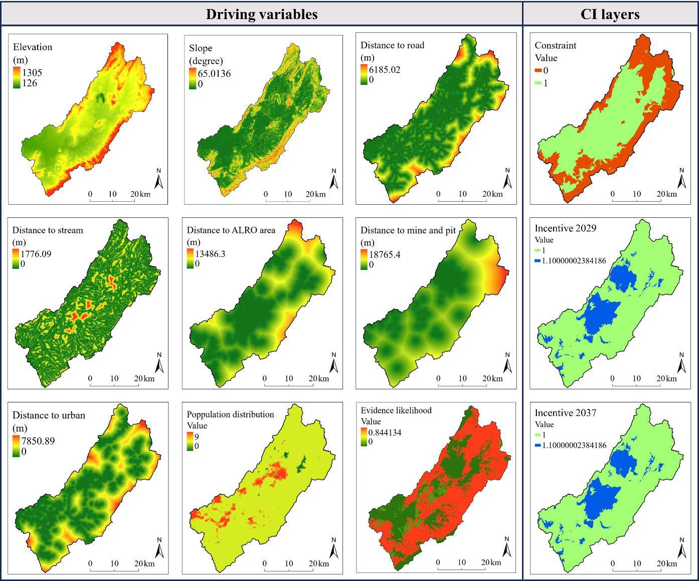
The Mae Chang watershed is part of the headwaters of the Wang River, located in Lampang Province in Northern Thailand. Resource pressures at forest-agriculture-extractive frontiers make this landscape crucial for studying land-habitat conversion and guiding sustainable land-use planning. Thus, this study interpreted LULC (1989, 2005, 2013, 2021) and projected LULC for 2029 and 2037 under BAU, conservation (CON), and development (DEV) scenarios using TerrSet’s LCM-MLP with local drivers, isolating intervention effects by contrasting CON/DEV (with constraint and incentive (CI) layers) against BAU (no CI). From 1989 to 2021, deciduous forest declined 23.3% (-249.01 km²), from 1,070.41 to 821.40 km² (65.40→50.18% of the watershed; -15.2 percentage points), while field crops increased by 104.7%, perennial crops by 97.3%, mines/pits by 240.8%, and urban areas by 28.8% based on human activity. Sub-model accuracies ranged 53-92%, and validation achieved Kstandard 0.824, Kno 0.861, Klocation 0.893, exceeding the success threshold. The three future scenarios yielded similar projected areas in both 2029 and 2037 but there were location differences. The deciduous forest area in 2029 and 2037 declined by 22.3% and 31.5%, respectively for all scenarios compared with 2021. The CON scenario outperformed BAU/DEV because strict no-conversion constraints in protected forests and restricted area effectively prevent ongoing deforestation, offering a practical simulation-based tool to support and implement land-use policies at local and regional scales. These findings provide a validated, transferable framework that isolates policy effects and supports evidence-based land-use planning in tropical headwatersheds.
Article Details

This work is licensed under a Creative Commons Attribution-NonCommercial 4.0 International License.
Published articles are under the copyright of the Environment and Natural Resources Journal effective when the article is accepted for publication thus granting Environment and Natural Resources Journal all rights for the work so that both parties may be protected from the consequences of unauthorized use. Partially or totally publication of an article elsewhere is possible only after the consent from the editors.
References
Abbasnezhad B, Abrams JB, Hepinstall-Cymerman J. Incorporating social and policy drivers into land-use and land-cover projection. Sustainability 2023;15:Article No. 14270.
Aghababaei M, Ebrahimi A, Naghipour AA, Asadi E, Verrelst J. Monitoring of plant ecological units cover dynamics in a semiarid landscape from past to future using multi-Layer Perceptron and Markov chain model. Remote Sensing 2024;16(9):Article No. 1612.
Alcamo J, Kok K, Busch G, Priess JA, Eickhout B, Rounsevell M, et al. Searching for the future of land: Scenarios from the local to the global scale. In: Lambin EF, Geist H, editors. Land-Use and Land-Cover Change: Local Processes and Global Impacts. Global Change-The IGBP Series. Berlin, Heidelberg: Springer; 2006. p. 137-56.
Anderson JR, Hardy EE, Roach JT, Witmer RE. A Land Use and Land Cover Classification System for Use with Remote Sensor Data. (US Geological Survey Professional Paper; 964). Washington D.C.: US Government Printing Office; 1976.
Anucharn T, Hongpradit P, Iamchuen N, Puttinaovarat S. Spatial analysis of urban expansion and energy consumption using nighttime light data: A comparative study of Google Earth Engine and traditional methods for improved living spaces. ISPRS International Journal of Geo-Information 2025; 14:Article No. 178.
Arunsurat R. Analyzing Future Land Cover Change in Chiang Mai-Lamphun Basin Using GIS and Multi-Scenarios Modeling [dissertation]. Graduate School, Chiang Mai University; 2022.
Arunsurat R, Wangpakapattanawong P, Sharp A, Khokthong W. Multi-scenario simulations of future forest cover changes influenced by Socio-economic development: A case study in the Chiang Mai-lamphun basin. EnvironmentAsia 2023; 16(1):1-15.
Bachri S, Shrestha RP, Sumarmi, Irawan LY, Masruroh H, Prastiwi MRH, et al. Land use change simulation model using a land change modeler in anticipation of the impact of the Semeru volcano eruption disaster in Indonesia. Environmental Challenges 2024;14:Article No. 100862.
Broquet M, Campos FS, Cabral P, David J. Habitat quality on the edge of anthropogenic pressures: Predicting the impact of land use changes in the Brazilian Upper Paraguay River Basin. Journal of Cleaner Production 2024;459:Article No. 142546.
Campbell JB, Wynne RH, Thomas VA. Introduction to Remote Sensing. 6th ed. New York: Guilford Press. 2022.
Chansawang A. Land and land reform. Kasetsart Journal of Social Sciences 1984,5:62-8 (in Thai).
Chen S, Yao S. Identifying the drivers of land expansion and evaluating multi-scenario simulation of land use: A case study of Mashan County, China. Ecological Informatics 2023;77:Article No. 102201.
Chotikasathira S. The Role of Watershed Classes in Water Flow and Its Characteristics of Ping-Wang River Basins [dissertation]. Graduate School, Kasetsart University; 1988 (in Thai).
Chotpantarat S, Boonkaewwan S. Impacts of land-use changes on watershed discharge and water quality in a large intensive agricultural area in Thailand. Hydrological Sciences Journal 2018;63:1386-407.
Christensen M, Arsanjani J. Stimulating implementation of sustainable development goals and conservation action: Predicting future land use/cover change in Virunga National Park, Congo. Sustainability 2020;12(4):Article No. 1570.
Chuankamnerdkarn N. Land Use Change Projection in 2050 for Eastern Thailand using Land Change Modeler. Bangkok, Thailand: Faculty of Liberal Arts, Thammasat University; 2020 (in Thai).
Congalton RG, Green K. Assessing the Accuracy of Remotely Sensed Data: Principles and Practices. 3rd ed. Boca Raton, Florida: CRC Press; 2019.
Dey NN, Al Rakib A, Kafy A-A, Raikwar V. Geospatial modelling of changes in land use/land cover dynamics using Multi-layer Perceptron Markov chain model in Rajshahi City, Bangladesh. Environmental Challenges 2021;4:Article No. 100148.
Eastman JR. Terrset Geospatial Monitoring and Modeling System Manual. Massachusetts: Clark Labs, Clark University; 2016.
Eastman JR. TerrSet liberaGIS Geospatial Monitoring and Modeling System Manual. Massachusetts: Clark Clark Labs, Clark University; 2024.
Eastman JR, Toledano J. A short presentation of the land change modeler (LCM). In: Camacho Olmedo M, Paegelow M, Mas JF, Escobar F, editors. Geomatic Approaches for Modeling Land Change Scenarios. Lecture Notes in Geoinformation and Cartography. Cham, Switzerland: Springer International Publishing; 2018. p. 499-505.
Electricity Generating Authority of Thailand (EGAT). Progress of the evacuation of people in Ban Dong Subdistrict. Electricity Generating Authority of Thailand [Internet]. 2022 [cited 2024 Oct 10]. Available from: https://mpp.egat.co.th/hellomaemoh/ index.php?option=com_content&view=article&id=853:2022-02-01-08-10-09&catid=10&Itemid=101 (in Thai).
Entahabu HH, Minale AS, Birhane E. Modeling and predicting land use/land cover change using the land change modeler in the Suluh River Basin, northern highlands of Ethiopia. Sustainability 2023;15(10):Article No. 8202.
Fitzpatrick-Lins K. Comparison of sampling procedures and data analysis for a land-use and land-cover map. Photogrammetric Engineering and Remote Sensing 1981;47(3):343-51.
Gandharum L, Hartono DM, Karsidi A, Ahmad M, Prihanto Y, Mulyono S, et al. Past and future land use change dynamics: Assessing the impact of urban development on agricultural land in the Pantura Jabar Region, Indonesia. Environmental Monitoring and Assessment 2024;196:Article No. 645.
Gharaibeh A, Shaamala A, Obeidat R, Al-Kofahi S. Improving land-use change modeling by integrating ANN with Cellular Automata-Markov Chain model. Heliyon 2020;6(9):Article No. 05092.
Giljum S, Maus V, Kuschnig N, Luckeneder S, Tost M, Sonter LJ, et al. A pantropical assessment of deforestation caused by industrial mining. Proceedings of the National Academy of Sciences of the United States of America 2022;119: e2118273119.
Gine X. Land Security in Rural Thailand: Evidence from Property Rights Reform. World Bank Policy Research. Vol. 3734. Washington (DC): World Bank; 2005.
Gomes E, Inácio M, Bogdzevič K, Kalinauskas M, Karnauskaitė D, Pereira P. Future land-use changes and its impacts on terrestrial ecosystem services: A review. Science of the Total Environment 2021;781:Article No. 146716.
Hasan S, Shi W, Zhu X, Abbas S, Khan HUA. Future simulation of land use changes in rapidly urbanizing South China based on Land Change Modeler and remote sensing data. Sustainability 2020;12(11):Article No. 4350.
Hormwichian R, Kaewplang S, Kangrang A, Supakosol J, Boonrawd K, Sriworamat K, et al. Understanding the interactions of climate and land use changes with runoff components in spatial-temporal dimensions in the Upper Chi Basin, Thailand. Water 2023;15(19):Article No. 3345.
Hughes AC. Understanding the drivers of Southeast Asian biodiversity loss. Ecosphere 2017;8:e01624.
Iamchuen N, Lamlet P, Anucharn T, Wongsagoon T. A comparison of future simulation of land use models in urbanization: A case study of Buriram District, Buriram Province. The Journal of Spatial Innovation Development 2023;4(1):60-75 (in Thai).
Intergovernmental Science-Policy Platform on Biodiversity and Ecosystem Services (IPBES). Summary for Policymakers of the Global Assessment Report on Biodiversity and Ecosystem Services of the Intergovernmental Science-Policy Platform on Biodiversity and Ecosystem Services. Bonn, Germany: IPBES Secretariat; 2019. p. 56.
Intergovernmental Panel on Climate Change (IPCC). Summary for Policymakers. In: Climate Change and Land: An IPCC Special Report on Climate Change, Desertification, Land Degradation, Sustainable Land Management, Food Security, and Greenhouse Gas Fluxes in Terrestrial Ecosystem. Cambridge University Press; 2019.
Kayitesi NM, Guzha AC, Tonini M, Mariethoz G. Land use land cover change in the African Great Lakes Region: A spatial-temporal analysis and future predictions. Environmental Monitoring and Assessment 2024;196(9):Article No. 852.
Kimario EP, Mbilinyi B, Hieronimo P. To evaluate future wetland degradation at Wami Ruvu River Basin from 2020 to 2050 using remote sensing imagery and hybrid ca-markov model. African Journal on Land Policy and Geospatial Sciences 2024;7(1):15-38.
Land Development Department. State of Soil and Land Resources of Thailand [Internet]. 2015 [cited 2024 Oct 10]. Available from: https://e-library.ldd.go.th/library/Ebook/bib9456.pdf (in Thai).
Land Development Department. Land use in Thailand [Internet]. 2023 [cited 2024 Sep 13]. Available from: http://www1.ldd.go.th/web_OLP/index.html (in Thai).
Lee K, Wangpakapattanawong P, Khokthong W. Evaluating forest cover changes in protected areas using geospatial analysis in Chiang Mai, Thailand. Chiang Mai University Journal of Natural Sciences 2022;21(2):e2022030.
Leta MK, Demissie TA, Tränckner J. Modeling and prediction of land use land cover change dynamics based on Land Change Modeler (LCM) in Nashe watershed, Upper Blue Nile basin, Ethiopia. Sustainability 2021;13(7):Article No. 3740.
Lin X, Zhang S, Hou X, Xu Z. Impact of land use change on watershed soil erosion under different development scenarios. Environmental Engineering Science 2022;39(4): 379-92.
Liu Y, Ziegler AD, Wu J, Liang S, Wang D, Xu R, et al. Effectiveness of protected areas in preventing forest loss in a tropical mountain region. Ecological Indicators 2022;136: Article No. 108697.
Losiri C, Nagai M, Ninsawat S, Shrestha R. Modeling urban expansion in Bangkok Metropolitan Region using demographic-economic data through Cellular Automata-Markov Chain and Multi-Layer Perceptron-Markov Chain models. Sustainability 2016;8(7):Article No. 686.
Marine Department. Guideline for Dredging and Restoring Mae Jang River, Lampang Province. Ministry of Transport [Internet]. 2023 [cited 2024 Sep 17]. Available from: https://www.oic.go.th/FILEWEB/CABINFOCENTER23/DRAWER004/GENERAL/DATA0001/00001239.PDF (in Thai).
Mishra VN, Rai PK, Mohan K. Prediction of land use changes based on land change modeler (LCM) using remote sensing: A case study of Muzaffarpur (Bihar), India. Journal of the Geographical Institute Jovan Cvijic SASA 2014;64(1):111-27.
Mishra VN, Rai PK, Prasad R, Punia M, Nistor M-M. Prediction of spatio-temporal land use/land cover dynamics in rapidly developing Varanasi District of Uttar Pradesh, India, using geospatial approach: A comparison of hybrid models. Applied Geomatics 2018;10:257-76.
Office of Natural Resources and Environmental Policy and Planning. Thailand’s National Biodiversity Action Plan 2023-2027. Bangkok: Ministry of Natural Resources and Environment; 2024. p. 224.
Office of the National Water Resources. Summary Report of Basic Information on the Wang River Basin: Project for Developing Basic Databases of 22 River Basins. Kasetsart University; 2020.
Office of the National Water Resources. Download data for the 22 watershed areas [Internet]. 2021 [cited 2024 Sep 18]. Available from: http://www.onwr.go.th/?page_id=9893 (in Thai).
Ongsomwang S. Principles of Remote Sensing and Digital Image Processing. Nakhon Ratchasima, Thailand: School of Remote Sensing, Institute of Science, Suranaree University of Technology; 2011. p. 466 (in Thai).
Ongsomwang S, Boonchoo K. Integration of geospatial models for the allocation of deforestation hotspots and forest protection units. Suranaree Journal of Science and Technology 2016;23(3):283-307.
Paiboonvorachat C, Oyana TJ. Land-cover changes and potential impacts on soil erosion in the Nan Watershed, Thailand. International Journal of Remote Sensing 2011; 32(21):6587-609.
Pansak W, Takrattanasaran N, Nongharnpitak N, Khongdee N. Soil-related laws in Thailand: International Yearbook of Soil Law and Policy 2022. Cham: Springer International Publishing; 2024. p. 243-62.
Phonphan W, Arunplod C, Wongsongja N, Utarasakul T, Niemmanee T, Kayee P, et al. Evaluating spatiotemporal dynamics: A comparative study of predictive efficacy in land use land cover change Models-Markov Chain, CA-ANN, and PLUS. International Journal of Geoinformatics 2024;20(6):13-25.
Pontius RG. Quantification error versus location error in comparison of categorical maps. Photogrammetric Engineering and Remote Sensing 2000;66(8):1011-6.
Pontius RG. Statistical methods to partition effects of quantity and location during comparison of categorical maps at multiple resolutions. Photogrammetric Engineering and Remote Sensing 2002;68(10):1041-9.
Proswitz K, Edward MC, Evers M, Mombo F, Mpwaga A, Näschen K, et al. Complex socio-ecological systems: Translating narratives into future land use and land cover scenarios in the Kilombero catchment, Tanzania. Sustainability 2021;13(12): Article No. 6552.
QGIS Development Team. QGIS Geographic Information System. Version 3.22.10. QGIS Association; 2022.
Raja Shekar P, Mathew A. Detection of land use/land cover changes in a watershed: A case study of the Murredu watershed in Telangana state, India. Watershed Ecology and the Environment 2023;5:46-55.
Saluja R, Maung TM, Piman T, Loc HH. Land use transitions in the lower Songkhram River Basin in Mekong and its impact on carbon sequestration potential. ACS ES&T Water 2024;4(7):2918-31.
Schreinemachers P, Fröhlich HL, Clemens G, Stahr K. From challenges to sustainable solutions for upland agriculture in Southeast Asia. In: Fröhlich HL, Schreinemachers P, Stahr K, Clemens G, editors. Sustainable Land Use and Rural Development in Southeast Asia: Innovations and Policies for Mountainous Areas. Berlin Heidelberg, Germany: Springer; 2013.
Shrestha M, Mitra C, Rahman M, Marzen L. Mapping and predicting land cover changes of small and medium size cities in Alabama using machine learning techniques. Remote Sensing 2022;15:Article No. 106.
Sreejan C. Legal measures for agricultural land reform and national reserved forest protection. Graduate Law TU Journal 2024;17(3):417-41 (in Thai).
Story M, Congalton R. Accuracy assessment: A user’s perspective. Photogrammetric Engineering and Remote Sensing 1986;52(3):397-9.
Suwanlertcharoen T, Prukpitikul S, Buakaew V, Kaewpoo N. Land use and land cover prediction and change detection using Geo-informatics in Khlong Kui Watershed, Prachuap Khiri Khan Province. Proceedings of the Geoinfotech; 2013 Dec 25-27; Geo-Informatics and Space Technology Development Agency (Public Organization), IMPACT Forum Muang Thong Thani, Bangkok: Thailand; 2013 (in Thai).
Tongdeenok P. Watershed management and classification in Thailand. BIO Web of Conferences 2023;80:Article No. 03024.
Trisurat Y, Shirakawa H, Johnston JM. Land-use/land-cover change from Socio-economic drivers and their impact on biodiversity in Nan Province, Thailand. Sustainability 2019;11:Article No. 649.
Tscharntke T, Batáry P, Clough Y, Kleijn D, Scherber C, Thies C, et al. Combining biodiversity conservation with agricultural intensification. In: Cunningham S, Young A, Lindenmayer D, editors. Land Use Intensification: Effects on Agriculture, Biodiversity and Ecological Processes. Australia: CSIRO Publishing; 2012. p. 7-15.
Van der Esch S, ten Brink B, Stehfest E, Bakkenes M, Sewell A, Bouwman A, et al. Exploring Future Changes in Land Use and Land Condition and the Impacts on Food, Water, Climate Change and Biodiversity: Scenarios for the Global Land Outlook. Hague, Netherlands: PBL Netherlands Environmental Assessment Agency; 2017.
Vasanthawada SRS, Puppala H, Prasad PRC. Assessing impact of land-use changes on land surface temperature and modelling future scenarios of Surat, India. International Journal of Environmental Science and Technology 2023;20(7):7657-70.
Wang Y, Hu Y, Niu X, Yan H, Zhen L. Land use/cover change and its driving mechanism in Thailand from 2000 to 2020. Land 2022;11(12):Article No. 2253.
Winkler K, Fuchs R, Rounsevell M, Herold M. Global land use changes are four times greater than previously estimated. Nature Communications 2021;12(1):Article No. 2501.
Woon SHJ, Srinuansom K, Chuah CJ, Ramchunder SJ, Promya J, Ziegler AD. Pre-closure assessment of elevated arsenic and other potential environmental constraints to developing aquaculture and fisheries: The case of the Mae Moh mine and power plant, Lampang, Thailand. Chemosphere 2021;269: Article No. 128682.
Zadbagher E, Becek K, Berberoglu S. Modeling land use/land cover change using remote sensing and geographic information systems: case study of the Seyhan Basin, Turkey. Environmental Monitoring and Assessment 2018; 190(8):Article No. 494.
