Forest Cover and Landslide Susceptibility Assessment Using a Machine Learning Approach in Northern Midland and Mountainous Region of Vietnam 10.32526/ennrj/24/20250178
Article Sidebar
Main Article Content
Abstract
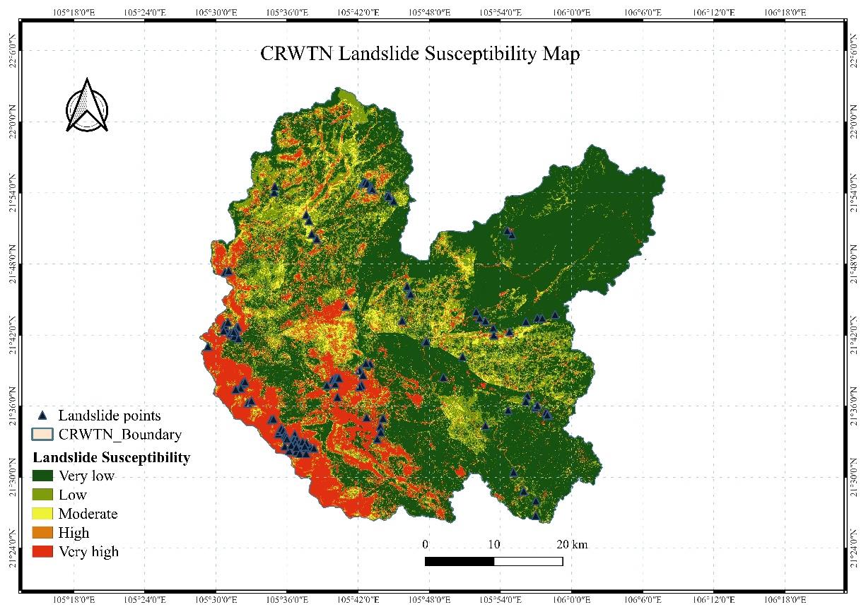
Landslides are a major geo-environmental hazard in Vietnam’s midland and mountainous regions, further intensified by land-use pressures and climate change. This study investigated the influence of forest cover on landslide susceptibility in Cau River Watershed. A forest status map was constructed using inventory and field data by the K-Nearest Neighbors (KNN) algorithm, while landslide susceptibility was modeled using historical events and nine conditioning factors through a hybrid machine learning approach integrating Random Forest (RF), Multilayer Perceptron (MLP) and KNN. The proposed hybrid model achieved an overall accuracy of 85.33%, demonstrating its robustness in susceptibility prediction. Results indicated that natural and native-species forests significantly reduce landslide density and susceptibility relative to non-forested areas and exotic plantations. These findings highlight the critical role of forest structure and species composition in stabilizing slopes. The study provides evidence-based insights to guide adaptive land management, forest policy, and regional strategies for climate resilience and sustainable development.
Article Details

This work is licensed under a Creative Commons Attribution-NonCommercial 4.0 International License.
Published articles are under the copyright of the Environment and Natural Resources Journal effective when the article is accepted for publication thus granting Environment and Natural Resources Journal all rights for the work so that both parties may be protected from the consequences of unauthorized use. Partially or totally publication of an article elsewhere is possible only after the consent from the editors.
References
Breiman L. Random forests. Machine Learning 2001;45:5-32.
Bui DT. Spatial prediction of rainfall-induced landslides for the Lao Cai Area (Vietnam) using a hybrid intelligent approach of least squares support vector machines inference model and artificial bee colony optimization. Landslides 2017;14:447-58.
Bui DT, Shirzadi A, Shahabi H, Pham BT, Singh SK, Chapi K, et al. A novel integrated approach of random forest-multilayer perceptron with rotation forest for landslide susceptibility assessment. Environmental Earth Sciences 2022;81:Article No. 215.
Chen C, Shen Z. Modeling landslide susceptibility in forest-covered areas in Lin’an, China, using logistic regression, decision tree, and random forest. Remote Sensing 2023;15(18):Article No. 4378.
Chen WP, Pan L. Applying population-based evolutionary algorithms and a neuro-fuzzy system for modeling landslide susceptibility. Catena 2019;172:212-31.
Food and Agriculture Organization of the United Nations (FAO). Forests and Landslides: The Role of Trees and Forests in the Prevention of Landslides and Rehabilitation of Landslide-Affected Areas in Asia. Rome: FAO; 2013.
Harrison O. Machine learning basics with the K-nearest neighbors algorithm [Internet]. 2018 [cited 2025 Jul 15]. Available from: https://towardsdatascience.com/machine-learning-basics-with-the-k-nearest-neighbors-algorithm-6a6e71d01761.
James G, Witten D, Hastie T, Tibshirani R. An Introduction to Statistical Learning. Vol. 112. New York: Springer; 2013. p. 18.
Le TT, Kaneko S. Landslide detection analysis in north Vietnam based on satellite images and digital geographical information: Landsat 8 satellite and historical data approaches. Japan Society of Civil Engineering 2017;73(5):239-49.
Murgia I, Vitali A, Giadrossich F, Tonelli E, Baglioni L, Cohen D, et al. Effects of land cover changes on shallow landslide susceptibility using SlideforMAP software (Mt Nerone, Central Italy). Land 2024;13(10):Article No. 1575.
Pham BT, Jaafari A, Prakash I, Bui DT. Naïve bayes-random subspace hybrid model for landslide susceptibility mapping. Geoscience Frontiers 2021;12(1):101-12.
Schmaltz EM, Steger S, Glade T. The influence of forest cover on landslide occurrence explored with spatio-temporal information. Geomorphology 2017;285:250-64.
Thai Nguyen Forest Protection Department (TNFPD). Forest Inventory Data 2023. Thai Nguyen, Vietnam: TNFPD; 2024.
Tran T, Trieu H, Bantayan N. GIS-based hybrid machine learning for landslide susceptibility assessment in Thai Nguyen Province, Vietnam. Proceedings of the 2024 Geoinformatics for Spatial-Infrastructure Development in Earth and Allied Sciences (GIS-IDEAS) Conference IEEE Special Track; 2024 Dec 11-13; Grand Vista Hotel, Chiang Rai: Thailand; 2024.
Vietnam Administration of Forestry (VAF). Vietnam Annual Forest Data. Hanoi: VAF; 2024.
Vietnam Disaster Management Authority (VNDMA). Vietnam 20-year Floods and Landslides Handbook. Hanoi: VNDMA; 2023a.
Vietnam Disaster Management Authority (VNDMA). Disaster Management Report. Hanoi: VNDMA; 2023b.
Vietnam General Statistics Office (VNGSO). Statistical Yearbook of Vietnam 2023. Hanoi: Statistical Publishing House; 2024.
Wang Y, Yin K, Zhang N, Zhang L. Landslide susceptibility mapping using recurrent neural network frameworks. Landslides 2022;19:437-52.
World Bank (WB). Country Forest Note: Vietnam. Washington, DC: WB; 2019.
