Modeling Land-Use Transitions under Conflicting Conservation and Land Tax Policies in Bang Kachao, Thailand 10.32526/ennrj/24/20250311
Article Sidebar
Main Article Content
Abstract
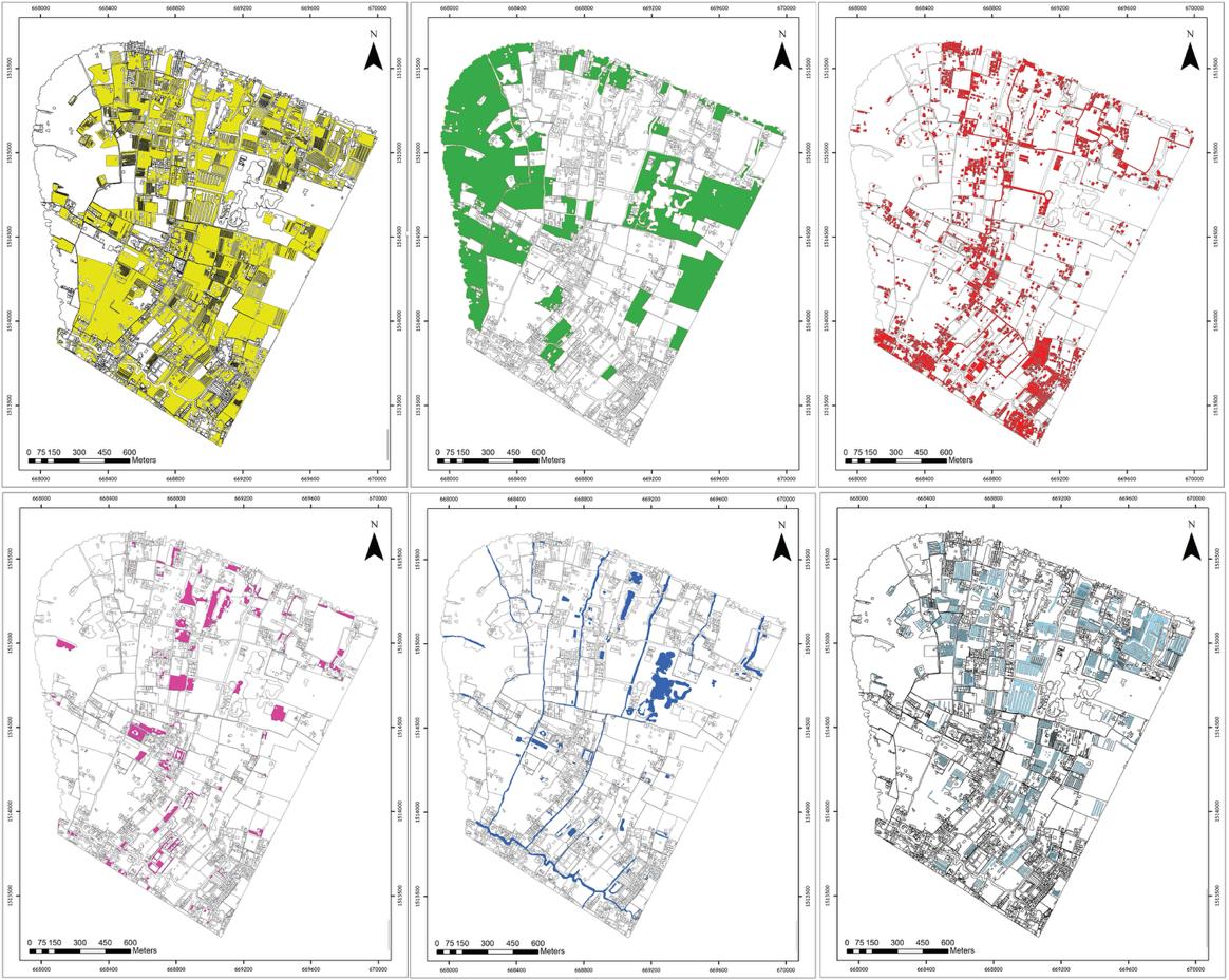
Bang Kachao Subdistrict faces a policy conflict between the 2019 conservation zoning regulation, which mandates at least 25% green cover, and the Land and Buildings Tax Act in 2019, which progressively increases idle land tax rates from 0.5% to 3% within three years. The rising tax burden has accelerated land conversion from vacant and forested plots to monoculture farms, threatening local ecosystem integrity. Using high-resolution drone imagery and high-resolution satellite imagery obtained from Google Earth Pro for the year 2005 and 2015, six land-use classes were mapped and projected to 2045. The model achieved an overall accuracy of 89.7% (Kappa = 0.86), forecasting a 14.1% decline in forest area (-0.144 km²), 15.9% agricultural net increase (+0.185 km²), and an increase in idle land from 0.031 km² to 0.094 km² over the 40-year period. Field surveys confirmed that landowners replaced nipa palm wetlands with eucalyptus plantations to qualify for tax exemptions. These results indicate that progressive taxation can undermine conservation policies. It is recommended that subdistrict governors establish Memoranda of Understanding (MOUs) with landowners to support nipa palm and native forest restoration through capped tax rates and integrated land-use zoning.
Article Details

This work is licensed under a Creative Commons Attribution-NonCommercial 4.0 International License.
Published articles are under the copyright of the Environment and Natural Resources Journal effective when the article is accepted for publication thus granting Environment and Natural Resources Journal all rights for the work so that both parties may be protected from the consequences of unauthorized use. Partially or totally publication of an article elsewhere is possible only after the consent from the editors.
References
Agisoft LLC. Agisoft Metashape Professional, version 2.0 [Internet]. 2022 [cited 2025 Nov 11]. Available from: https://www.agisoft.com/.
Albut S. Land use land change utilizing the QGIS MOLUSCE plugin. In: Gundogu S, editor. Mimarlıkta İleri Araştırmalar. Ankara, Turkey: YAZ Yayınları; 2024. p. 172-88.
Alfonso-Bécares D, Giampietro M, Corbera E, Serrano-Tovar T. Advancing the understanding of forest conservation dynamics through livelihood and landscape change scenarios: A case study in Chiapas, Mexico. Environment Development and Sustainability 2024;26(12):29957-79.
Apriani RN, Inayati I. Alternative policy on progressive tax rate on Idle Land in the Special Capital Territory of Jakarta. Public Administration Journal 2020;10(2):127-37.
BIOFIN. The impacts of harmful subsidies on biodiversity and ecosystems in Thailand [Internet]. 2024 [cited 2025 Nov 11]. Available from: https://www.biofin.org/knowledge-product/impacts-harmful-subsidies-biodiversity-and-ecosystems-thailand.
Bol TT, Randhir TO. Predicting land use and land cover changes in the Chindwin River Watershed of Myanmar using multilayer perceptron-artificial neural networks. Land 2024;13(8):Article No. 1160.
Department of Marine and Coastal Resources (DMCR). Thailand’s mangrove forests to be land-tax exempt [Internet]. 2024 [cited 2025 Nov 11]. Available from: https://www.bangkokpost.com/thailand/general/2924855/thailands-mangrove-forests-to-be-land-tax-exempt.
Esri. ArcGIS Desktop: ArcMap, version 10.8 [Internet]. 2020 [cited 2025 Nov 11]. Available from: https://desktop.arcgis.com/.
Jing H, Liu Y, Hou J. Impacts of agricultural intensification on biodiversity: habitat loss, agrochemical use, water depletion, and soil degradation. Journal of Environmental Management 2025;395:Article No. 128036.
Kalkuhl M, Fernandez Milan B, Schwerhoff G, Jakob M, Hahnen M, Creutzig F. Fiscal Instruments for Sustainable Development: The Case of Land Taxes. Berlin, Germany: Mercator Research Institute on Global Commons and Climate Change (MCC); 2017.
Khan N, Raza M, Shakoor MSA, Biswas F, Rahaman M. Dynamic of population growth and its effect on land use/land cover of bahraich district in Uttar Pradesh. Journal of Environmental Studies and Sciences 2023;13(1):124-40.
Kögel M, Feile L, Möldner F, Carstensen D. SSegRef2Surf—Near Real-time photogrammetric flood monitoring and refinement of classified water surfaces. Remote Sensing 2025;17(8): Article No. 1351.
Liu S, Li X, Chen D, Duan Y, Ji H, Zhang L, et al. Understanding land use/land cover dynamics and impacts of human activities in the Mekong Delta over the last 40 years. Global Ecology and Conservation 2020;22:e00991.
Torres AL, Olivera MV, Almeida Del Savio A, Bambarén GG. Effect of Climatological factors on the horizontal accuracy of photogrammetric products obtained with UAV. Sensors 2024;24(22):Article No. 7236.
Mukul SA, Saha N. Conservation benefits of tropical multifunctional land-uses in and around a forest protected area of Bangladesh. Land 2017;6(1):Article No. 2.
Nanakorn P. Land and Buildings Tax Act, B.E 2562 (2019). Bangkok, Thailand: Office of the Council of State; 2019.
NextGIS. MOLUSCE: Modules for Land Use Change Evaluation [Internet]. 2019 [cited 2025 Nov 11]. Available from: https://plugins.qgis.org/plugins/molusce/.
Orina JA, Tontisirin N, Anantsuksomsri S. Reviews on the land use and land cover changes in Bangkok. International Journal of Building, Urban, Interior and Landscape Technology 2024;22(2):Article No. 252537.
Pokavanich T, Guo X. Saltwater intrusion in Chao Phraya Estuary: A long, narrow and meandering partially mixed estuary influenced by water regulation and abstraction. Journal of Hydrology: Regional Studies 2024;52:Article No. 101686.
Raven PH, Wagner DL. Agricultural intensification and climate change are rapidly decreasing insect biodiversity. Proceedings of the National Academy of Sciences of the United States of America 2021;118(2):e2002548117.
Saksornchai J. Govt moves to protect Bangkok’s famed “green lung” [Internet]. 2019 [cited 2025 Nov 11]. Available from: https://www.khaosodenglish.com/news/bangkok/2019/03/28/govt-moves-to-protect-bangkoks-famed-green-lung/.
Taylor L, Hochuli DF. Defining greenspace: Multiple uses across multiple disciplines. Landscape and Urban Planning 2017;158:25-38.
Tripathi RN, Ramachandran A, Tripathi V, Badola R, Hussain SA. Optimizing riparian habitat conservation: A spatial approach using aerial and space technologies. IEEE Journal of Selected Topics in Applied Earth Observations and Remote Sensing 2024;17:16932-43.
Yotapakdee T, Asanok L, Kamyo T, Norsangsri M, Karnasuta N, Navakam S, et al. Benefits and value of big trees in urban area: A study in Bang Kachao Green Space, Thailand. Environment and Natural Resources Journal 2018;17(1):33-43.
Zhang S, Barrett HA, Baros SV, Neville PRH, Talasila S, Sinclair LL. Georeferencing accuracy assessment of historical aerial photos using a custom-built online georeferencing tool. ISPRS International Journal of Geo-Information 2022;11(12):Article No. 582.
Zhao R, Luo X, Yang Y, Syahid LN, Chen C, Lee JSH. Cropland expansion drives vegetation greenness decline in Southeast Asia. Biogeosciences 2024;21(23):5393-406.
