Smoke Haze Problem and Open Burning Behavior of Local People in Chiang Rai Province
Article Sidebar
Main Article Content
Abstract
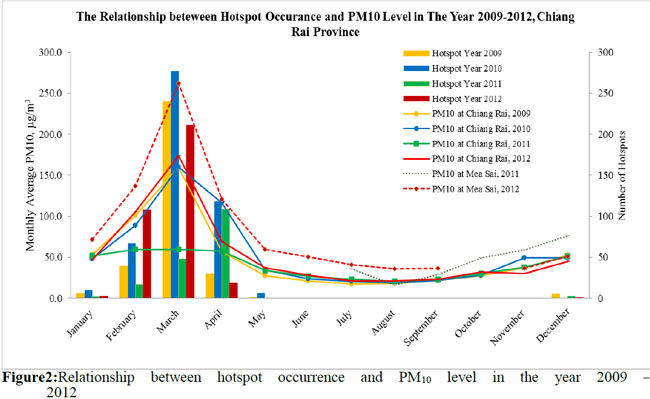
This research aims to study the relationship between air quality and open burning behavior of local people in Chiang Rai Province. In the analyzing process, concentrations of Particle Matter or PM10 levels data documented by Pollution Control Department and the results from a field survey in 2012 were used as key parts. In addition, hotspot data obtained from MODIS Satellite System was used to represent fire occurrence. Satellite images from Landsat 5 TM 2007 was also brought in to be compared with the satellite images of the year 2010, the most critical year, in order to discover burned areas. Statistics of monthly average of PM10 and average number of hotspot occurrences from January - April in 2008 – 2012 were employed to compare the relationship between them. As a consequence, their pattern relationship was found to have a relatively similar trend. Moreover, by using supervised classification, the satellite images showed that in 2007 and 2010 the burned areas in Chiang Rai were 4,340 km2 or 37.46% and 4,386 km2 or 37.86% of the total provincial area respectively. From the field survey, it was found that most of these areas were repeated burning sites, mainly located in the forest where agricultural burning was normally conducted. Therefore, changing land use to minimize open burning is most likely another possible option to solve the smoke haze problem in Chiang Rai.
Article Details
Published articles are under the copyright of the Environment and Natural Resources Journal effective when the article is accepted for publication thus granting Environment and Natural Resources Journal all rights for the work so that both parties may be protected from the consequences of unauthorized use. Partially or totally publication of an article elsewhere is possible only after the consent from the editors.
