
Assessing street greenery using imagery of Google Street View
Article Sidebar
Main Article Content
Abstract
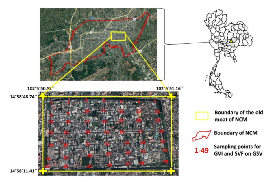
The streets at the old moat of Nakhon Ratchasima City Municipality (NCM) are a critical point of urban landscape. NCM people interact with streetscape in terms of well-being. This paper proposes the application of Google Street View (GSV) for surveying street greenery. This study focused on 15 streets at the old moat of NCM using 49 sampling points for designing and analyzing Green View Index (GVI) and Sky View Factor (SVF) on analysis of GSV images. GVI was used for estimating the percent of vegetation cover and SVF was used for quantifying the ratio of sky cover. According to the result, the GVI calculations were found between 1.41 – 44.18 percent that drivers or walkers could see green cover in the low percent (or < 50 percent). SVF value is between 0.73 – 0.86 that drivers or walkers could see clearly sky on 15-street at the old moat of NCM. These results show that all streets at the old moat of NCM should improve vegetation cover. Moreover, the application of GSV for surveying street greenery will be an alternative tool for geospatial workers or planners in green cities.
Article Details

This work is licensed under a Creative Commons Attribution-NonCommercial-NoDerivatives 4.0 International License.
References
C, Xiao, Q. Shi, C,-J. Gu, Assessing the Spatial Distribution Pattern of Street Greenery and Its Relationship with Socioeconomic Status and the Built Environment in Shanghai, China, Land 10 (2021) 871.
X. Li, C. Zhang, W. Li, R. Ricard, Q. Meng, W. Zhang, Assessing street-level urban greenery using Google Street View and a modified view index, Urban Forestry & Urban Greening 14(1) (2015) 675-685.
X. Li, C. Ratti, I. Seiferling, Mapping Urban Landscapes Along Streets Using Google Street View, Li, in: International Cartographic Conference, Washington, DC, 2017, pp. 341-356.
W. Klemm, B. G. Heusinkveld, S. Lenzholzer, B. Hove, Street greenery and its physical and psychological impact on thermal comfort, Landscape and Urban Planning 138 (1) (2015) 87-98.
R. Dong, Y. Zhang, J. Zhao, How Green Are the Streets Within the Sixth Ring Road of Beijing? An Analysis Based on Tencent Street View Pictures and the Green View Index, International Journal of Environmental Research and Public Health 15(7) (2018) 1367.
D. Ki, S. Lee, Analyzing the effects of Green View Index of neighborhood streets on walking time using Google Street View and deep learning, Landscape and Urban Planning 205 (2021) 103920.
F. Biljecki, K. Ito, Street view imagery in urban analytics and GIS: A review, Landscape and Urban Planning 215 (1) (2021) 104217.
K. Ito, F. Biljecki, Assessing bikeability with street view imagery and computer vision, Transportation Research Part C 132 (1) 103371.
J. Poracsky, D. Banis, Street Trees in the Urban Forest Canopy: Portland, Oregon, Project Report of Portland State University; 2005, Available from: https://pdxscholar.library.pdx.edu/cgi/viewcontent.cgi?article=1023&context=geog_fac (accessed 18 Dec 2021).
Phytosphere Research, Ground survey, Guidelines for Developing and Evaluating Tree Ordinances; 2013, Available from http://phytosphere.com/treeord/ordprt3d.htm (accessed 18 Dec 2021).
State of NSW and Department of Planning, Surveying threatened plants and their habitats, Project Report of NSW government; 2020, Available from https://www.environment.nsw.gov.au/-/media/OEH/Corporate-Site/Documents/Animals-and-plants/Biodiversity/surveying-threatened-plants-and-habitats-nsw-survey-guide-biodiversity-assessment-method-200146.pdf (accessed 18 Dec 2021).
Office of Nakhonratchasima City Municipality, Memorandum of Understanding (MOU) in project of Korat Smart City, Meeting Paper; 2019, Available from: https://www.koratcity.go.th/archives/69 (accessed 19 Dec 2021).
Y. Jantakat, N. Chatpuak, P. Juntakut, C. Jantakat, A Web Information System for Promoting Cultural Tourism in The Old Moat of Nakhonratchasima City Municipality. International Journal of Building, Urban, Interior and Landscape Technology (BUILT) 15 (1) (2020) 65-76.
NACTO, Urban street design guide, Technical Report; 2013, Available from https://www.metamorphosis-project.eu/sites/default/files/downloads/Urban_Street_Design_Guide_NACTO.pdf (accessed 19 Dec 2021).
E. Williams, A. Harper, Street Trees and Intersection Safety, IURD Working Paper Series; 2006, Available from https://nacto.org/wp-content/uploads/2015/04/street_trees_and_intersection_safety_macdonald.pdf
Y. Jantakat, P. Juntakut, C. Jantakat, Application of Google Street View for Exploring Street Greenery, in: The 12th Built Environment Research Associates Conference (BERAC), Bangkok, 2021, pp. pp. 391-397.
P. Khartwell, Understanding the Sky View Factor, State of the art; 2017, Available from https://mau.hypotheses.org/271
D. G. Steyn, The calculation of view factors from fisheye‐lens photographs, Atmosphere-Ocean 18 (1980) 254–258.
A. Matzarakis, F. Rutz, H. Mayer, Modelling radiation fluxes in simple and complex environments: Basics of the RayMan model, International Journal of Biometeorology 51 (1) (2007) 323–334.
Z. Kokalj, K. Zaksek, K. Ostir, Visualizations of LIDAR derived relief models, in: Interpreting Archaeological Topography Airborne Laser Scanning, 3D Data and Ground Observation, Oxford, UK: Oxbow Books, 2013, pp.100-114.
A. Middle, J. Lukasczyk, R. Maciejewski, Sky View Factors from Synthetic Fisheye Photos for Thermal Comfort Routing—A Case Study in Phoenix, Arizona, Urban Planning 2(1) (2017) 19-30.
