Simulation of Water Losses for the 1D Salinity Forecasting Model in Chao Phraya River
doi: 10.14456/mijet.2022.20
Keywords:
Salinity intrusion, Chao Phraya River, water losses, salinity forecastAbstract
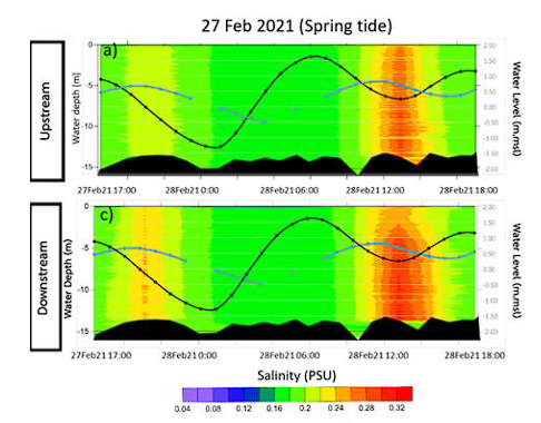
Salinity intrusion is one of a major problem in the Chao Phraya River during dry season. It affects salinity condition for water consumption and other uses. The pumping station of MWA is located at Sumlae station, Pathumthani Province, Thailand, about 80 km from Chao Phraya River mouth. During dry season when the freshwater is low the salinity can be intruded and affected the salinity level at this station. The salinity concentration becomes higher than the safe range for drinking water. The one-dimensional salinity forecasting model has been developed using 1D Mike11 AD model. The model has been setup operationally providing 7 days salinity forecast. When the salinity is forecasted to be higher than accepted range, freshwater will be released from the reservoir to flush the salt water out of the river. Although the overall accuracy is well satisfied, the water losses due to local abstraction along the river is still causing problem to the computed results. Therefore, the model has been setup to simulate the discharge losses into 4 cases; No loss, 40%, 50% and 60%, respectively. The forcing at the upstream river comprised of the release from main reservoirs and gates while at the river mouth, the boundary was adapted using the salinity forecast from HYCOM. The model results have been validated with the results from salinity survey during spring and neap tides in February 2021. The results were found that 60% loss of discharge provide the nearest results compared to the observation from salinogarpher and salinity at gauge station. This is confirmed that there is water loss along the river that need to be included in water flushing plan as well as in the model. The discharge station is recommended to install at Samelae station to measure the exact river discharge that may vary over time. This will improve the accuracy of salinity forecast model as well as the water management for salinity intrusion in Chao Phraya River.
References
S. Vongvisessomjai and S. Rojanakamthorn, "Analytical Model of Tide and River Flow Interaction," Thammasat Int. J. Sci. Technol., vol. 5, 01/01 2000.
D. K. Katsuhiko Nakamuro, Monthip Tabucanon, Wattana Sukasem, "A STUDY ON WATER QUALITY EVALUATION OF THE CHAO PHRAYA RIVER," Journal of The Science Society of Thailand : ScienceAsia, vol. 8, pp. 175-191, 1982.
S. Wongsa, "Impact of Climate Change on Water Resources Management in the Lower Chao Phraya Basin, Thailand," Journal of Geoscience and Environment Protection, vol. 03, pp. 53-58, 01/01 2015.
K. C. T. Charoensuk, N. Luangdilok, W. Thanathanphon, A. Mooktaree, T. Lolupiman, K. K. Kyaw and P. Sisomphon, "The study of the salinity intrusion behavior in the Chao Phraya River," National Conference on Water Resources Engineering, vol. 8, 2021 (in Thai).
K. C. T. Charoensuk, W. Thanathanphon and P. Sisomphon, "Monitor and Analyzing Salinity intrusion using Salinity Intrusion Forecast System in the Chao Phraya River During Tropical Pabuk 2019," (in Thai), The National Convention on Civil Engineering, vol. 25, 15-17 July 2020.
E. Metzger et al., "Validation Test Report for the Global Ocean Forecast System V3.0 - 1/12 deg HYCOM-NCODA: Phase II," pp. 74, 23 February 2010.
N. L. W. Thanathanphon, K. Chettanawanit, P. Sisomphon, "Storm Surge Forecasting and Inundation Estimation During Tropical Strom Pabuk 2019 in the Southern Coast of Thailand," the proceedings of the 22nd Congress of the International Association for Hydro-Environment Engineering and Research-Asia Pacific Division, vol. 22, 2020.

Downloads
Published
How to Cite
Issue
Section
License

This work is licensed under a Creative Commons Attribution-NonCommercial-NoDerivatives 4.0 International License.


