Spatiotemporal Change for Agricultural Distribution from Local Administrative to Provincial Scales-based Spatial Clustering Analysis
Keywords:
agricultural distribution, spatiotemporal analysis, spatial clustering analysisAbstract
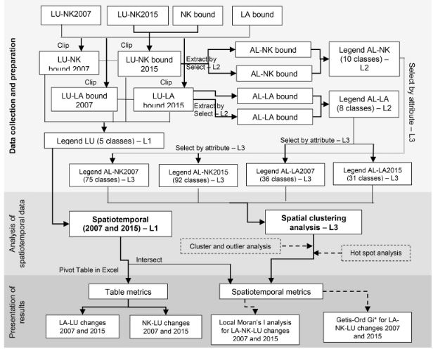
Nowadays, agricultural diversities and productions in Thailand have high competition in all scales. Therefore, this paper would like to study spatiotemporal change for agricultural distribution of from municipal to provincial scales-based spatial clustering analysis in case study of Nakhon Ratchasima (NK) province, Thailand. In this methodology, we presented a GIS-based spatiotemporal analysis with ArcGIS program that was used for spatiotemporal analysis in land use and spatial clustering models (using cluster and outlier and hot spots analysis) of agricultural distribution. This study used land use data between 2007 and 2015 from Land Development Department (LDD) through reference of land use classification system. As results, overall of land use between 2007 and 2015 in both municipal (298.21 km2) and provincial (20,727.35 km2) scale, was found that agricultural land was the highest number (> 50%), mostly paddy fields. Agricultural change in all municipal areas in NK decreased from 2007 to 2015 (1.62 km2 or 0.54%) while overall NK province increased (46.23 km2 or 0.22%). For spatial clustering analysis, cluster and outlier results showed the difference of municipal (two groups: HH clusters and HL outliers) and provincial areas (four groups: two clusters (HH and LL) and two outliers: (HL and LH). Interesting, high-density of agricultural lands (HH clusters) was found as active paddy fields in both municipalities and province were seen in more nearby locations in 2015, located in north, south-eastern and middle-west areas. In hot spots-based Gi* analysis, hot-spot areas in both municipal and provincial areas in 2015 were more increased than 2007 that indicated highly agricultural area density. Moreover, we found that such density of agricultural area included diversity of agricultural classification based on 3rd level of LDD classification system as same, i.e. ., sugarcane, corn, cassava, custard apple, pasture. Conversely, the decreased change of cold-spot areas in 2007 and 2015 was found that was paddy field, was happened in the south-eastern locations. Consequently, these obtained results will be able to support and contribute for national security policy 2015-2021, focuses on policy no. 12: strengthening energy and food security through adaptation or survival from climate change. Especially, in food security, it will response (1) to support the active participation of the private sector or social entrepreneurship organizations and (2) to contribute market access and agricultural value chains for smallholders.
Downloads
References
Alatorre, L. C., & Begueria, S., (2010). Analysis of Spatial and Temporal Evolution of the NDVI on Vegetated and Degraded Areas in The Central Spanish Pyrenees. Int. Arch. Photogramm. Remote Sens. Spatial Inf. Sci., XXXVIII-Part7A, 7-12.
Asadi, S. S., Vuppala, P., & Anji Reddy, M. (2007). Remote sensing and GIS techniues for evaluation of groundwater quality in municipal corporation of Hyderabad (zone-v). International Journal of Environmental Research Public Health, 4(1), 45-52.
Alexandratos, N., & Bruinsma, J. (2012). World agriculture towards 2030/2050: the 2012 revision. Retrieved on July 6, 2019, from http://www.fao.org/3/a-ap106e.pdf
Barow, I., Megenta, M., & Megento, T. (2019). Spatiotemporal analysis of urban expansion using GIS and remote sensing in Jigjiga town of Ethiopia. Applied Geomatics, 11(2), 121-127.
Bil, M., Andrasik, R., & Sedonik, J. (2019). A detailed spatiotemporal analysis of traffic crash hotspots.Applied Geography, 107, 82-90.
Dadhich, A. P., Coyal, R., & Dadhich, P. N. (2018). Assessment of spatio-temporal variations in air quality of Jaipur city, Rajasthan, India. The Egyptian Journal of Remote Sensing and Space Sciences, 21, 173-181.
ESRI. (2018a). Cluster and Outlier Analysis (Anselin Local Moran’s I). Retrieved May 18, 2019, from http://desktop.arcgis.com/en/arcmap/10.3/tools/spatial-statistics-toolbox/cluster-and-outlier-analysis-anselin-local-moran-s.htm
ESRI. (2018b). Hot Spot Analysis (Getis-Ord GI*). Retrieved May 18, 2019, from http://desktop.arcgis.com/en/arcmap/10.3/tools/spatial-statistics-toolbox/hot-spot-analysis.htm
Fortin, M. J., & Dale, M. (2005). Spatial Analysis: A Guide for Ecologists. Chapter 6 In “Spatiotemporal Analysis” Cambridge University Press, 256-316.
Furberg, D., & Ban, Y. (2012). Satellite monitoring of urban sprawl and assessment of its potential environmental impact in the Greater Toronto Area between 1985 and 2005. Environmental management, 50(6), 1068-1088.
Haas, J., & Ban, Y. (2014). Urban growth and environmental impacts in Jing-Jin-Ji, the Yangtze, River Delta and the Pearl River Delta. International Journal of Applied Earth Observation and Geoinformation, 30, 42-55.
Haas, J., & Ban, Y. (2015). Synergy of Sentenel-1A SAR and Sentenel-2A MSI data for urban ecosystem service mapping. Paper presented at the 35th EARSeL Symposium - European Remote Sensing: Progress, Challenges and Opportunities, Stockholm, Sweden, June 15-18 2015.
Han, J., Kamber, M., & Tung, A. K. H. (2001). Spatial Clustering Methods in Data Mining: A Survey. Retrieved on July 15, 2019, from https://www.comp.nus.edu.sg/~atung/publication/gkdbk01.pdf
Jantakat, Y., Juntakut, P., Plaiklang, S., Arree, W., & Jantakat, C. (2019). Spatiotemporal change of urban agriculture using Google Earth Imagery: A Case of Municipality of Nakhonratchasima City, Thailand. The International Archives Photogrammetry Remote Sensing Spatial Information Sciences, XLII-2/W13, 1307-1312.
Jantakat, Y., Juntakut, P., & Kranka, S. (2018). Applied Geo-Informatics Technology to Urban Green Space Management on Role of Stormwater Runoff Reducing and Increasing of Subsurface Water. Sirindhorn Conference on Geoinformatics (SCGI), 15-24.
Jantakat, Y., & Juntakut, P. (2017). Final report: Applied GeopInfomatics Teachnology to Urban Green Space Management on Role of Stormwater Runoff Reducing and Increasing of Subsurface Water in Nakhonratchasima City Municipality. Thailand: Rajamangala University of Technology ISAN.
Jin, C. Xu, J., & Huang, Z. (2019). Spatiotemporal analysis of regional tourism development: A semiparametric Geogaphically Weighted Regression model approach. Habitat International, 87, 1-10.
Juntakut, P., & Jantakat, Y. (2019). Impact of Urbanization on Quality and Quantity of Groundwater in Nakhon-Nayok Province, Thailand. BUILT, 13 (1), 83-95.
Land development Department (LDD). (2018). Land Use in North-Eastern Region. Retrieved September 10, 2019, from http://www1.ldd.go.th/WEB_OLP/report_research_NE.html
Mugiraneza, T., Haas, J., & Ban, Y., (2017).Spatiotemporal Analysis of Urban Land Cover Changes in Kigali, Rwanda using Multitemporal Landsat Data and Landscape Metrics. Int. Arch. Photogramm. Remote Sens. Spatial Inf. Sci., XLII-3/W2, 137-144.
Neethu, C. V. & Surendran, S. (2013). Review of Spatial Clustering Methods. International Journal of Information Technology Infrastructure, 2(3), 15-24.
Peeters, A., Zude, M., Kathner, J., Unlu, M., Kanber, R., Hetzroni, A. Gebbers, R., & Ben-Gal, A. (2015). Getis-Ord’s hot-and cold-spot statistics as a basis for multivariate spatial clustering of orchard tree data. Computers and Electonics in Agriculture, 111(1), 140-150.
Thitiprassert, W., Ratanasatien, Chitrakon, S., Watanesk, O., Chotechuen, S., Forrer, V. S., Sommut, W., Somsri, S., Samitaman, P., & Changtragoon, S. (2007). Country Report on The State of Plant Genetic Resources for Food and Agriculture in Thailand (1997-2004). Retrieved on July 8, 2019, from http://www.fao.org/3/i1500e/Thailand.pdf
Varghese, B. M., Unnikrishnan, A., & Poulose Jacob, K. (2013). Spatial Clustering Algorithms – An Overview. Asian Journal of Computer Science and Information Technology, 3(1), 1-8.
Downloads
Published
How to Cite
Issue
Section
License
Copyright (c) 2019 International Journal of Building, Urban, Interior and Landscape Technology (BUILT)

This work is licensed under a Creative Commons Attribution-NonCommercial-NoDerivatives 4.0 International License.