Assessing Green City-based Tree Cover Change in Nakhonratchasima City Municipality
Keywords:
Green city, Tree cover change, Spatial and temporal change, Google Earth imageryAbstract
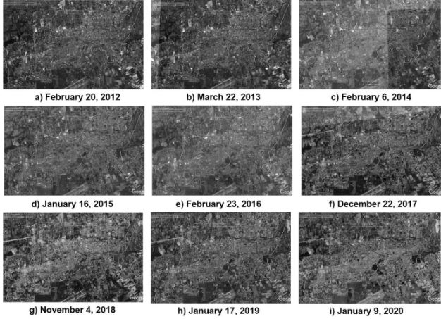
Many cities has set goal of green city with tree increasing. The objective of this study is to assess green city-based tree cover change in Nakhonratchasima City Municipality (NCM). In analysis, Google Earth (GE) imagery during 2012-2020 was used for visual interpretation but the result of Urban Tree Canopy (UTC) cover interpretation on GE image in year 2020 only was evaluated accuracy in field and was used to be the base map for supporting GE photo-interpretation in the past (2012-2019). The result of annually UTC cover layers would be taken to estimate air pollutants ((CO, NO2, O3, PM10, M2.5 and SO2) via i-Tree Canopy on web. As results, the accuracy assessment of UTC cover map in year 2020 is 96.5517%. Tree cover change during the varying periods were found that there were ranged from dramatic reduction in percent tree cover of 17.2873% in year 2013 (because of built-up areas’ increasing in that time) and slight reducing 0.0561% in year 2015 to an increase in percent tree cover of 0.3122% in year 2016 and 0.0488% in year 2017 while percent tree cover has been gradually decreased between 2018 and 2020. At the same time, NCM’s UTC cover included the highest total removal value of CO (17.0 x 10⁻⁷ % per year) in year 2017; of NO2 (74.0 x 10⁻⁷ % per year) in year 2013, 2014 and 2017; of O3 (711.0 x 10⁻⁷ % per year) in year 2015; of PM10 (240.0 x 10⁻⁷ % per year) in year 2013 and 2014; of PM2.5 (38.0 x 10⁻⁷ % per year) in year 2017; of SO2 (48.0 x 10⁻⁷ % per year) in year 2013 and 2014. This assessment of such pollutant removal should not only be considered by tree cover but also the concerned factors (i.e., pollution concentrate, length of in-leaf season, amount of precipitation, and other meteorological variables). The mentioned results above, they will be used for spatial information for planning green city in area of NCM and guiding other green cities. Consequently, this study suggests for next work as: (1) study relationship between tree cover and land use/land cover and (2) study other related factors for UTC cover change.
Downloads
References
Anchang, J. Y., Prihodko, L., Ji, W., Kumar, S. S., Ross, C. W., Yu, Q., Lind, B., Sarr, M. A., Diouf, A. A. & Hanan, N. P. (2020). Toward operational mapping of woody canopy cover in tropical savannas using Google Earth Engine. Frontiers in Environmental Science, 8(4), 1-17. doi:10.3389/fenvs.2020.00004
Baldocchi, D., (1988). A multi-layer model for estimating sulfur dioxide deposition to a deciduous oak forest canopy. Atmospheric Environment, 22, 869–884. doi:10.1016/0004-6981(88)90264-8
Baldocchi, D.D., Hicks, B.B., Camara, P., (1987). A canopy stomatal resistance model for gaseous deposition to vegetated surfaces. Atmospheric Environment, 21, 91–101. doi:10.1016/0004-6981(87)90274-5
Batten, J. & Edwads, C. (2015). Sustainable Cities Index 2015. Retrieved from https://www.arcadis.com/media/E/F/B/%7BEFB74BBB-D788-42EF-A761-4807D69B6F70%7D9185R_Arcadis_whitepaper_2015.pdf
Beatley, T. (2012). Green Cities of Europe. Washington, United States of America: Island Press.
Bidwell, R.G.S.& Fraser, D.E. (1972). Carbon monoxide uptake and metabolism by leaves. Canadian Journal of Botany, 50, 1435–1439.
Blackman, R. & Yuan, F. (2020). Detecting long-term urban forest cover change and impacts of natural disasters using high-resolution aerial images and LIDAR data. Remote Sensing, 12, 1820. doi:10.3390/rs12111820
Center for Watershed Protection. (2018). Urban tree canopy. Retrieved from https://www.cwp.org/urban-tree-canopy/
Edmond. (2017). What is urban tree canopy? Retrieved from http://edmondok.com/1403/What-is-Urban-Tree-Canopy
Ellis, E. A. & Mathews, A. J. (2019). Object-based delineation of urban tree canopy: assessing change in Oklahoma City, 2006-2013. Computers, Environment and Urban Systems, 73, 85-94. doi:10.1016/j.compenvurbsys.2018.08.006
Elmes, A., Rogan, J., Williams, C., Ratick, S., Nowak, D. & Martin, D. (2017). Effect of urban tree canopy loss on land surface temperature magnitude and timing. ISPRS Journal of Photogrammetry and Remote Sensing, 128, 338-353. doi:10.1016/j.isprsjprs.2017.04.011
Fitzpatrick-Lins, K. (1981). Comparison of Sampling Procedure and Data Analysis for a Land-use and Land-cover Map. Photogrammetric Engineering & Remote Sensing, 55(4), 475-478.
Food and Agriculture Organization of the United Nations (FAO). (2018). Forests and sustainable cities: Inspiring stories from around the world. Retrieved from http://www.fao.org/3/I8838EN/i8838en.pdf
Hirabayashi, S., Nowak, D., Maco, S., Endreny, T. & Kroll, C.(2011). : i-Tree: tools to assess and manage structure, function, and value of community forests. Retrieved from https://www.researchgate.net/publication258458756_i-Tree_Tools_to_assess_and_manage_structure_function_and_value_of_community_forests/link0f317537a0775b47f0000000/download
Hwang, W. H. & Wiseman, P. E. (2020). Geospatial methods for tree canopy assessment: A case study of an urbanized college campus. Arboriculture & Urban Forestry, 46(1), 51-65.
Hwang, W. H. (2013). i-Tree Canopy, a web-based Tool for Rapid UTC Analysis and Planning. Retrieved from https://www.urbanforestry.frec.vt.edu/UTC/documents/iTreeCanopy.pdf
Jantakat, Y. & Juntakut, P. (2020). Application of Geographic Information System for Monitoring Land Use Changes in Nakhonratchasima City Municipality. Proceedings of The 5th Regional Conference on Graduate Research on 18 January 2020 at Sripatum University, Khon Kaen Campus, Khon Kaen, Thailand, 217-224.
Jensen. J. R. (2007). Remote Sensing of the Environment: An Earth Resource Perspective. (The 2nd Edition). New Jersey, United States: Practice Hall.
Kokubu, Y., Hara, S. & Tani, A. (2020). Mapping seasonal tree canopy cover and leaf area using worldview-2/3 satellite imagery: a megacity-scale case study in Tokyo urban area. Remote Sensing, 12, 1505. doi:10.3390/rs12091505
Konda, M. C., Mueller, N., Locke, D. H., Roman, L. A., Rojas- Rueda, D., Schinasi, L. H., Gascon, M., & Nieuwenhuijsen, M. J. (2020). Health impact assessment of Philadephia’s 2025 tree canopy cover goals. Retrieved from https://www.thelancet.com/action/showPdf?pii=S2542-5196%2820%2930058-9
Lovett, G.M. (1994). Atmospheric deposition of nutrients and pollutants in North America: an ecological perspective. Ecological Applications 4, 629–650.
Lowry, J. H., Baker, M. E. & Ramsey, R. D. (2012). Determinants of urban tree canopy in residential neighborhoods: Household characteristics, urban form, and the geophysical landscape. Urban Ecosystem, 15, 247-266. doi:10.007/s11252-011-0185-4
Malarvizhi, K., Vasantha Kumar, S. & Porchelvan, P. (2016). Use of High Resolution Google Earth Satellite Imagery in Landuse Map Prepration for Urban Related Applications. Procedia Technology, 24, 1835-1842. doi:10.1016/j.protcy.2016.05.231
Nowak, D. J. & Greenfield, E. J. (2020). The increase of impervious cover and decrease of tree cover within urban areas globally (2012-2017). Urban Forestry & Urban Greening, 49, 126638. doi:10.1016/j.ufug.2020.126638
Norwak, D. J., Hoehn, R. E., Bodine, A. R., Greenfield, E. J. & O’Neil-Dunne, J. (2013a). Urban forest structure, ecosystem services and change in Syracuse, NY. Retrieved from https://www.fs.fed.us/nrs/pubs/jrnl/2013/nrs_2013_nowak_003.pdf
Nowak, D. J., Hirabayashi, S., Bodine, A. & Hoehn, R. (2013b). Modeled PM2.5 removal by trees in ten U.S. cities and associated health effects. Environmental Pollution, 178, 395-402. doi:10.1016/j.envpol.2013.03.050
Nowak, D. J., Hoehn, R. E., Crane, D. E., Stevens, J. C., Cumming, J., Mohen, S. & Cumming, A. B. (2012). Assessing urban forest effects and values: Morgantown’s urban forest. Retrieved from https://www.nrs.fs.fed.us/pubs/42367
Nowak, D. & Greenfield, E. J. (2012a). Tree and impervious cover change in U.S. cities. Urban Forestry & Urban Greening, 11, 21-30. doi:10.1016/j.ufug2011.11.005
Nowak, D. & Greenfield, E. J. (2012b). Tree and impervious cover in the United States. Landscape and Urban Planning, 107, 21-30. doi:10.1016/j.landurbplan.2012.04.005
Nowak, D. J., Crane, D. E., & Stevens, J. C. (2006). Air pollution removal by urban trees and in the United States. Urban Forestry & Urban Greening, 4, 115-123. doi:10.1016/j.ufug.2006.01.007
Poracsky, J. & Banis, D. (2005). Street Trees in the Urban Forest Canopy: Portland, Oregon. Retrieved from https://pdxscholar.library.pdx.edu/cgi/viewcontent.cgi?article=1023&context=geog_fac
Potz, H. & Bleuze, P. (2013). Urban green-blue grids for sustainable and dynamic cities. Retrieved from https://www.gebiedsontwikkeling.nu/artikelen/urban-green-blue-grids-for-sustainable-and-dynamic-cities/
Shen, Z., Huang, L., Peng, K. & Pai, J. (2018). Green City Planning and Practices in Asian Cities. Zurich, Switzerland: Springer International Publishing.
Shields, Katherine & Langer, H. (2009). European Green City Index. Retrieved from https://assets.new.siemens.com/siemens/assets/api/uuid:fddc99e7-5907-49aa-92c4-610c0801659e/european-green-city-index.pdf
Snedecor, G.W. & Cochran, W.G. (1967). Statistical methods. 6th Edition. Iowa, USA: The Iowa State University Press.
Stein, R., Vorisek, D. & Hussaini, N. (2011). US and Canada Green City Index. Retrieved from https://grist.org/wp-content/uploads/2011/07/northamerican-gci-report-e.pdf
Tangprasit, P. (2010). Korat floods: Repetitive problems are not solved. Retrieved from https://www.posttoday.com/politic/report/57467
THAIRATH online, 2017, Flood in 8 districts of Korat and flash flood in 3 districts: the governor feared a new storm repeatedly collapsed, Available Source: https://www.thairath.co.th/news/local/northeast/1018965
THAIRATH online, 2010, Floods in many areas in Korat, worst severe in 50 years, Available Source: https://www.thairath.co.th/content/119277
Thai PBS NEWS, 2010, Korat-Prachin floods are still a crisis, Available Source: https://news.thaipbs.or.th/content/218475
Tirla, M.-L., Manea, G., Vijulie, I., Matei, E. & Cocos, O. (2014). Green Cities – Urban Planning Models of the Future. Retrieved from https://www.researchgate.net/publication/294580768_Green_Cities_-_Urban_Planning_Models_for_the_Future/link/5de686c4a6fdcc2837033cd3/download
Urban Forestry Research Group. (2020). Step-by-step guide to conducting an i-Tree Canopy study. Retrieved from https://www.forestresearch.gov.uk/documents/7230/i-Tree_Canopy_-_Ward_Project_-_User_Guide_-_April_2020B.pdf
USDA Forest Service, Davey Tree Expert Company, the Arbor Day Foundation, Society of Municipal Arborists, the International Society of Arboriculture and Casey Trees. (2006). I-Tree Streets: User’s Manual. Retrieved from https://www.itreetools.org/support/resources-overview/i-tree-manuals-workbooks
World Health Organization (WHO), (2020). Urban population growth. Retrieved from https://www.who.int/gho/urban_health/situation_trends/urban_population_growth_text/en/
World Health Organization (WHO). (2009). Healthy Transport in Developing Cities. Retrieved from https://www.who.int/heli/risks/urban/transportpolicybrief2010.pdf?ua=1
Yan-Tao, G., Xiao-Mei, Z., Teng-Fei, L., Wei-Li, J., Guo-Jin, H., Ran-Yu, Y. & Yun-Yun, D. (2020). China forest cover extraction based on Google Earth Engine. The International Archives of the Photogrammetry, Remote Sensing and spatial Information Sciences, XLII-3/W10, 855-862. doi:10.5194/isprs-archives-XLII-3-W10-855-2020
Zhao, J. & Zhao, X. (2020). Observed canopy evapotranspiration enhancement of green patches in Chinese metropolis. Retrieved from https://ui.adsabs.harvard.edu/abs/2020EGUGA..22.4494Z/abstract
Zinke, P.J. (1967). Forest interception studies in the United States. In W.E. Sopper, & H.W. Lull (Eds.), Forest Hydrology. (pp. 137–161). Pergamon Press, Oxford.
Downloads
Published
How to Cite
Issue
Section
License
Copyright (c) 2020 International Journal of Building, Urban, Interior and Landscape Technology (BUILT)

This work is licensed under a Creative Commons Attribution-NonCommercial-NoDerivatives 4.0 International License.