Assessment and Prediction of Land Use/Land Cover Change in the National Capital of Burundi Using Multi-temporary Landsat Data and Cellular Automata-Markov Chain Model 10.32526/ennrj/19/202100023
Article Sidebar
Main Article Content
Abstract
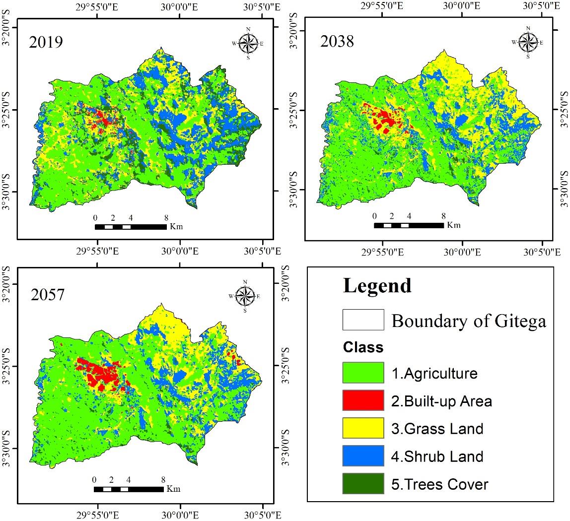
Gitega District has experienced significant land use and land cover changes due to human activity. This has increased land degradation and environmental issues. However, there is no data on LULC change to guide land-use planning. This study assessed the rate and magnitude of LULC change over the last 35 years and also simulated future scenarios using Geoinformatics. In the first step, five LULC classes were extracted from satellite images from 1984, 2002, and 2019 using the supervised classification method. Overall accuracy and Kappa statistics of more than 85% and 82% respectively were achieved with 30 reference samples. Change analysis highlighted by Land Change Modeler (1984-2019) indicated a significant increase in Agriculture of 94 km2, a slight increase in Shrub Land and Built-up Area of 5.5 km2 and 2 km2, respectively; and a steep decrease in Trees Cover and Grass Land of 62.5 km2 and 39 km2, respectively. Markov Chain and CA-Markov models were further calibrated to simulate LULC changes in 2038 and 2057 using the 2019 base map. Evaluation and analysis of 2019-2057 simulation results showed a moderate agreement of 75% for Kappa and the same trends of LULC change: Trees Cover, Grass Land, and Shrub Land will decrease by 11.5 km2, 13 km2, 11.5 km2 respectively, whereas Agriculture and Built-up Area will increase by 30 km2 and 6 km2 respectively in 2057. These study outcomes can support decision-making towards restoration measures of land degradation and long-term environmental conservation in the region.
Article Details
Published articles are under the copyright of the Environment and Natural Resources Journal effective when the article is accepted for publication thus granting Environment and Natural Resources Journal all rights for the work so that both parties may be protected from the consequences of unauthorized use. Partially or totally publication of an article elsewhere is possible only after the consent from the editors.
References
Alawamy JS, Balasundram SK, Hanif AHM, Sung CTB. Detecting and analyzing land use and land cover changes in the region of Al-Jabal Al-Akhdar, Libya using time-series landsat data from 1985 to 2017. Sustainability 2020;12(11):4490.
Anderson JR. A Land Use and Land Cover Classification System for Use with Remote Sensor Data. US Government Printing Office; 1976.
Bai ZG, Dent DL, Olsson L, Schaepman ME. Proxy global assessment of land degradation. Soil Use and Management 2008;24(3):223-34.
Baker WL. A review of models of landscape change. Landscape Ecology 1989;2(2):111-33.
Berakhi RO. Implication of Human Activities on Land Use Land Cover Dynamics in Kagera Catchment, East Africa [dissertation]. Southern Illinois University Carbondale; 2013.
Boissière M, Sheil D, Basuki I, Wan M, Le H. Can engaging local people’s interests reduce forest degradation in Central Vietnam? Biodiversity and Conservation 2009;18(10): 2743-57.
Borana S, Yadav S. Comparison of model validation techniques for land cover dynamics in Jodhpur City. International Journal of Emerging Trends and Technology in Computer Science. 2017;6(5):215-9.
Burrell AL, Evans JP, Liu Y. The impact of dataset selection on land degradation assessment. Journal of Photogrammetry and Remote Sensing 2018;146:22-37.
Dewan AM, Yamaguchi Y. Using remote sensing and GIS to detect and monitor land use and land cover change in Dhaka Metropolitan of Bangladesh during 1960-2005. Environmental Monitoring and Assessment 2009;150(1-4):237.
Eastman JR. Idrisi Taiga guide to GIS and image processing [Internet]. 2009 [cited 2020 Oct 15]. Available from: http://web.pdx.edu/~nauna/resources/TaigaManual.pdf.
El-Hassanin A, Labib T, Gaber E. Effect of vegetation cover and land slope on runoff and soil losses from the watersheds of Burundi. Agriculture, Ecosystems and Environment 1993;43(3-4):301-8.
Food and Agriculture Organization (FAO). State of the world's forests, 2016: Forests and agriculture: Land use challenges and opportunities [Internet]. 2016 [cited 2021 Mar 7]. Available from: http://www.fao.org/3/a-i5588e.pdf.
Ghosh P, Mukhopadhyay A, Chanda A, Mondal P, Akhand A, Mukherjee S, et al. Application of cellular automata and markov-chain model in geospatial environmental modeling: A review. Remote Sensing Applications: Society and Environment 2017;5:64-77.
Gómez C, White JC, Wulder MA. Optical remotely sensed time series data for land cover classification: A review. ISPRS Journal of Photogrammetry and Remote Sensing. 2016; 116:55-72.
Guichaoua A. Population migrante et types de mobilité au Burundi. Les Cahiers d'Outre-Mer 1982;35(138):141-59 (in French).
Gupta R, Sharma LK. Efficacy of spatial land change modeler as a forecasting indicator for anthropogenic change dynamics over five decades: A case study of Shoolpaneshwar Wildlife Sanctuary, Gujarat, India. Ecological Indicators 2020;112:106171.
Halmy MWA, Gessler PE, Hicke JA, Salem BB. Land use/land cover change detection and prediction in the north-western coastal desert of Egypt using markov-CA. Applied Geography 2015;63:101-12.
Henry M, Maniatis D, Gitz V, Huberman D, Valentini R. Implementation of REDD+ in sub-Saharan Africa: State of knowledge, challenges and opportunities. Environment and Development Economics 2011;16(4):381-404.
Intergovernmental Science-Policy Platform on Biodiversity and Ecosystem Services (IPBES). Summary for policymakers of the assessment report on land degradation and restoration [Internet]. 2018 [cited 2021 Mar 10]. Available from: https://www.ipbes.net/system/tdf/spm_3bi_ldr_digital.pdf?file=1&type=node&id=28335.
Intergovernmental Panel on Climate Change (IPCC). Climate Change and Land: An IPCC Special Report on Climate Change, Desertification, Land Degradation, Sustainable Land Management, Food Security, and Greenhouse Gas Fluxes in Terrestrial Ecosystems. IPCC; 2019.
Islam K, Jashimuddin M, Nath B, Nath TK. Land use classification and change detection by using multi-temporal remotely sensed imagery: The case of Chunati wildlife sanctuary, Bangladesh. The Egyptian Journal of Remote Sensing and Space Science 2018;21(1):37-47.
Kamungi PM, Oketch JS, Huggins C. Land access and the return and resettlement of IDPs and refugees in Burundi: From the Ground Up. Project Relationships between Land Rights, Conflict and Peace in Sub-Sahara Africa. Pretoria: Institute for Security Studies; 2005 p. 195-267.
Kumar M, Mukherjee N, Sharma GP, Raghubanshi A. Land use patterns and urbanization in the holy city of Varanasi, India: A scenario. Environmental Monitoring and Assessment 2010;167(1):417-22.
Kundel HL, Polansky M. Measurement of observer agreement. Radiology 2003;228(2):303-8.
Lambin EF, Rounsevell MD, Geist HJ. Are agricultural land-use models able to predict changes in land-use intensity? Agriculture, Ecosystems and Environment 2000;82(1-3): 321-31.
Liu Q, Shi T. Spatiotemporal differentiation and the factors of ecological vulnerability in the Toutun River Basin based on remote sensing data. Sustainability 2019;11(15):4160.
Maingi J, Kepner S, Edmonds W. Accuracy assessment of 1992 landsat-MSS derived land cover for the Upper San Pedro Watershed (US/Mexico). Las Vegas: Environmental Protection Agency; 2002.
Marathianou M, Kosmas C, Gerontidis S, Detsis V. Land-use evolution and degradation in Lesvos (Greece): A historical approach. Land Degradation and Development 2000; 11(1):63-73.
Meyer WB, Turner BL. Changes in Land Use and Land Cover: A Global Perspective. United Kingdom: Cambridge University Press; 1994.
Mishra VN, Rai PK, Mohan K. Prediction of land use changes based on land change modeler (LCM) using remote sensing: A case study of Muzaffarpur (Bihar), India. Journal of the Geographical Institute Jovan Cvijic SASA 2014;64(1):111-27.
Mondal MS, Sharma N, Garg P, Kappas M. Statistical independence test and validation of CA markov land use land cover (LULC) prediction results. The Egyptian Journal of Remote Sensing and Space Science 2016;19(2):259-72.
Moore ML. An Examination of Contributing Factors to Land Use/Land Cover Change in Southern Belize and the Use of Satellite Image Analysis to Track Changes [dissertation]. Ames, Iowa State University; 2007.
Nadoushan MA, Soffianian A, Alebrahim A. Modeling land use/cover changes by the combination of markov chain and cellular automata markov (CA-Markov) models. Journal of Earth, Environment and Health Sciences 2015;1(1):16.
Ndzabandzaba C. Data Sharing for Sustainable Development in Less Developed and Developing Countries. Global Sustainable Development Report; 2015.
Nijimbere G, Lizana CR, Riveros РЛК. Assessment of soil erosion of Burundi using remote sensing and GIS by RUSLE model. RUDN Journal of Ecology and Life Safety 2019;27(1):17-28.
Niyogi D, Mahmood R, Adegoke JO. Land-use/land-cover change and its impacts on weather and climate. Boundary Layer Meteorology 2009;133(3):297.
Niyuhire MC. Integrated Soil Fertility Management for Bean-Maize Based Farming Systems in Gitega Province, Burundi: Understanding and Enhancing the Agronomic and Economic Benefits of Organic and Mineral Inputs [dissertation]. Belgium, KU Leuven; 2018.
Nzabakenga A, Feng LX, Yaqin H. Agricultural income determinants among smallholder farmers: Case of northern part of Burundi. Asian Journal of Agriculture and Rural Development 2013;3(11):780-7.
Patel SK, Verma P, Singh GS. Agricultural growth and land use land cover change in peri-urban India. Environmental Monitoring and Assessment 2019;191(9):1-17.
Patil MB, Desai CG, Umrikar BN. Image classification tool for land use/land cover analysis: A comparative study of maximum likelihood and minimum distance method. International Journal of Geology, Earth and Environmental Sciences 2012;2(3):189-96.
Pijanowski BC, Brown DG, Shellito BA, Manik GA. Using neural networks and GIS to forecast land use changes: A land transformation model. Computers, Environment and Urban Systems 2002;26(6):553-75.
Poursanidis D, Chrysoulakis N, Mitraka Z. Landsat 8 vs. Landsat 5: A comparison based on urban and peri-urban land cover mapping. International Journal of Applied Earth Observation and Geoinformation 2015;35:259-69.
Pulighe G, Baiocchi V, Lupia F. Horizontal accuracy assessment of very high resolution google earth images in the city of Rome, Italy. International Journal of Digital Earth 2016;9(4):342-62.
Rwanga SS, Ndambuki JM. Accuracy assessment of land use/land cover classification using remote sensing and GIS. International Journal of Geosciences 2017;8(04):611.
Sang L, Zhang C, Yang J, Zhu D, Yun W. Simulation of land use spatial pattern of towns and villages based on CA-markov model. Mathematical and Computer Modelling 2011;54(3-4):938-43.
Serneels S, Lambin EF. Proximate causes of land-use change in Narok District, Kenya: A spatial statistical model. Agriculture, Ecosystems an Environment 2001;85(1-3):65-81.
Shen L. Multi-Layer Perceptron-Markov Chain Based Geospatial Analysis of Land Use and Land Cover Change: A Case Study of Stoney Creek Watershed, BC, Canada [dissertation]. China, North China Electric Power University; 2019.
Singh AK. Modelling Land Use Land Cover Changes Using Cellular Automata in a Geo-Spatial Environment [dissertation]. Netherlands, ITC; 2003.
Song C, Woodcock CE, Seto KC, Lenney MP, Macomber SA. Classification and change detection using Landsat TM data: When and how to correct atmospheric effects? Remote Sensing of Environment 2001;75(2):230-44.
Surabuddin M, Sharma N, Kappas M, Garg P. Modeling of spatio-temporal dynamics of land use and land cover in a part of Brahmaputra River basin using Geoinformatic techniques. Geocarto International 2013;28(7):632-56.
Tilahun A, Islam Z. Google earth for land use land cover change detection in the case of Gish Abbay Sekela, West Gojjam, Amhara state, Ethiopia. International Journal of Society and Humanities 2015;3:80-7.
Torrens PM. How Cellular Models of Urban Systems Work (1. Theory). Centre for Advanced Spatial Analysis, UK: University College London; 2000.
Turner BL, Lambin EF, Reenberg A. The emergence of land change science for global environmental change and sustainability. Proceedings of the National Academy of Sciences 2007;104(52):20666-71.
Twisa S, Buchroithner MF. Land use and land cover change detection in Wami River Basin, Tanzania. Land 2019; 8(9):136.
United Nations Data Retrieval System (UNdata). A world of information [Internet]. 2020 [cited 2021 Mar 5]. Available from: https://data.un.org/en/iso/bi.html.
van Vliet J, Bregt AK, Hagen-Zanker A. Revisiting kappa to account for change in the accuracy assessment of land use change models. Ecological Modelling 2011;222(8):1367-75.
Vassolo S, Neukum C, Tiberghien C, Heckmann M, Hahne K, Baranyikwa D. Hydrogeology of a weathered fractured aquifer system near Gitega, Burundi. Hydrogeology Journal 2019;27(2):625-37.
Verburg PH. Simulating feedbacks in land use and land cover change models. Landscape Ecology 2006;21(8):1171-83.
Verma P, Raghubanshi A. Rural development and land use land cover change in a rapidly developing agrarian South Asian landscape. Remote Sensing Applications: Society and Environment 2019;14:138-47.
Vila JPS, Barbosa P. Post-fire vegetation regrowth detection in the Deiva Marina region (Liguria-Italy) using landsat TM and ETM+ data. Ecological Modelling. 2010;221(1):75-84.
Wang SW, Munkhnasan L, Lee WK. Land use and land cover change detection and prediction in Bhutan's high altitude city of Thimphu, using cellular automata and markov chain. Environmental Challenges 2021;2:100017.
