Analysis of Landslide Occurrence using DTM-Based Weighted Overlay: A Case Study in Tropical Mountainous Forest of Cameron Highlands, Malaysia 10.32526/ennrj/19/202100069
Article Sidebar
Main Article Content
Abstract
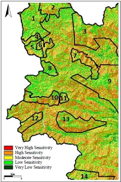
Landslides are massive natural disasters all around the world. In general, our society is only concerned with the landslides that can cause economic distress and impact human life. Landslides in remote areas such as mountainous forests have often been neglected. Referring to the historical disaster event, forest landslides have vast potential to cause unexpected ecological and social damage. This study reveals the terrain characteristics of the complex mountainous forest area of Cameron Highlands (CH), Malaysia, and demonstrates an approach to evaluate the terrain sensitivity of CH. Terrain assessment can be a powerful tool to prevent or reduce the risk of landslides. In this study, terrain features; elevation, slope gradient, aspect, topography wetness index (TWI), and length-slope factor (LS Factor) were extracted using a Digital Terrain Model (DTM) at 10 m resolution. The selected terrain features were incorporated using weighted overlay analysis to derive a terrain sensitivity map (TSM) using SAGA GIS software. The map identified five types of terrain sensitivity classified as very high sensitivity, high sensitivity, moderate sensitivity, low sensitivity, and very low sensitivity; these areas have a coverage of 0.78 km2, 114.31 km2, 107.50 km2, 102.99 km2, and 0.65 km2, respectively. The findings suggest that the sensitive areas are scattered throughout all of the mountainous forests of CH; thus, this enhanced the risk of landslide. Results showed 79.25% accuracy, which is satisfactory to be a guideline for forest management planning and assist decision making in the respective region.
Article Details
Published articles are under the copyright of the Environment and Natural Resources Journal effective when the article is accepted for publication thus granting Environment and Natural Resources Journal all rights for the work so that both parties may be protected from the consequences of unauthorized use. Partially or totally publication of an article elsewhere is possible only after the consent from the editors.
References
Abdullah AF, Aimrun W, Nasidi NM, Hazari SAF, Sidek M, Zalilah S. Modeling erosion and landslides induced by farming activities at hilly areas, Cameron Highlands, Malaysia. Jurnal Teknologi 2019;81(6):195-204.
Acharya TD, Yang IT, Lee DH. GIS-based landslide susceptibility mapping Bhotang, Nepal using frequency ration and statistical index methods. Journal of Korean Society of Surveying, Geodesy, Photogrammetry and Cartography 2017;35(5):357-64.
Ahmed F, Rao KS. Application of DEM and GIS in terrain analysis: A case study of Tuirini River Basin, NE India. International Journal of Geology and Earth Sciences 2019;5(1):1-20.
Anbalagan R. Landslide hazard evaluation and zonation mapping in mountainous terrain. Engineering Geology 1992;32:269-77.
Azita AZ, Muhammad-Shafeeq S, Thinaraj B, Paul L. Terrain characterization of mountainous forest area in Cameron Highland. The Malaysian Forester 2019;82(2):445-54.
Azlini R, Sharifah NSS, Suriyani A, Sarva MP, Emilia ZA. Land use change in highland area and its impact on river water quality: A review of case studies in Malaysia. Ecological Processes 2018a;7(19):1-17.
Azlini R, Sharifah NSS, Suriyani A, Sarva MP, Emilia ZA. Heavy metals contamination and potential health risk in highland river watershed (Malaysia). Malaysian Journal of Medicine and Health Sciences 2018b;14(2):45-55.
Battistini A, Rosi A, Segoni S, Lagomarsino D, Catani F, Casagli N. Validation of landslide hazard models using a semantic engine on online news. Applied Geography 2017;82:59-65.
Beaven PJ, Lawrance CJ. The Application of Terrain Evaluation to Road Engineering. Malaysia: Institution of Engineers, Public Works Department; 1973.
Chaudhari ARV, Lal BD, Dutta CS, Umrikar B, Halder ES. Weighted overlay analysis for delineation of ground water potential zone: A case study of Pirangut River basin. International Journal of Remote Sensing and Geoscience 2018;7(1):1-7.
Colby JD, Dobson JG. Flood modeling in the coastal plains and mountains: Analysis of terrain resolution. Natural Hazard Review 2010;11(1):19-25.
Conrad O, Bechtel B, Bock M, Dietrich H, Fischer E, Gerlitz L, et al. System for Automated Geoscientific Analyses (SAGA) v. 2.1.4. Geoscientific Model Development 2015;8:1991-2007.
Cruden DM. A simple definition of a landslide. Bulletin of the International Association of Engineering Geology 1991; 43(1):27-9.
DeGraff JV, Romesburg HC. Regional landslide-susceptibility assessment for wildland management. In: Coats DR, Vitek JD, editors. Thresholds in Geomorphology. London: George Allen and Unwin; 1980. p. 401-14.
Dermawan A. Findings of investigations into Jalan Bukit Kukus landslide tragedy must be made public-NGOs [Internet]. 2019 [cited 2019 Apr 24]. Available from: https://bit.ly/2FFMflb.
Dou J, Dieu TB, Yunus AP, Jia K, Song X, Revhaug I, et al. Optimization of causative factors for landslide susceptibility evaluation using remote sensing and GIS data in parts of Niigata, Japan. PLoS ONE 2015;10(7):1-29.
Fisher R, Hobgen S, Mandaya I, Kaho NR, Zulkarnain. Satellite Image Analysis and Terrain Modelling: A Practical Manual for Natural Resource Management, Disaster Risk and Development Planning Using Free Geospatial Data and Software. Charles Darwin University and Universitas Nusa Cendana dan Universitas Halu Oleo; 2017.
Forest Practices Code of British Columbia. Mapping and assessing terrain stability guidebook [Internet]. 1999 [cited 2020 Jan 12]. Available from: https://bit.ly/2FuruJh.
Froude MJ, Petley DN. Global fatal landslide occurrence from 2004 to 2016. Natural Hazards and Earth System Sciences 2018;18:2161-81.
Gong WF, Wang HB, Wang XF, Fan WY, Stott P. Effect of terrain on landscape patterns and ecological effects by a gradient-based RS and GIS Analysis. Journal of Forestry Research 2017;28:1061-72.
Gutierrez-Martin A, Herrada MA, Yenes JI, Castedo R. Development and validation of the terrain stability model for assessing landslide instability during heavy rain infiltration. Natural Hazards and Earth System Sciences 2019;19:721-36.
Jabatan Ukur dan Pemetaan Malaysia (JUPEM). How to get the JUPEM digital data? [Internet]. 2019 [cited 2019 Jun 12]. Available from: https://www.jupem.gov.my/soalan-lazim.
Jerkins E. Summary of weather in the Cameron Highlands-2nd edition. Regional Environmental Awareness Cameron Highland [Internet]. 2014 [cited 2019 Dec 18]. Available from: http://reach.org.my/2014/?p=709.
Kalimuthu H, Tan WN, Lim SL, Mohammad FAF. Assessing frequency ratio method for landslide susceptibility mapping in Cameron Highlands, Malaysia. Proceedings of the 2015 Institute of Electrical and Electronics Engineers Student Conference on Research and Development; 2015 Dec 13-14; Kuala Lumpur: Malaysia; 2015.
Kamilia S, Simon N, Rodeano R. Regional assessment on the influence of land use related factor on landslide occurrences in Kundasang, Sabah. Proceedings of the Universiti Kebangsaan Malaysia, Faculty of Science and Technology 2016 Postgraduate Colloquium; 2016 Apr 13-14; Universiti Kebangsaan Malaysia, Selangor: Malaysia; 2016.
Kavitha MNC, Viswanath R, Kavibharathi P, Aakash K, Balajimanikandan M. A comparative study of conventional surveying techniques with total station and GPS. International Journal of Civil Engineering and Technology 2018;9(1):440-6.
Kim H, Kang Y, Kim J. Evaluation of wind resource potential in mountainous region considering morphometric terrain characteristics. Wind Engineering 2017;41(2):114-23.
Kouhestani S, Eslamian SS, Abedi-Koupai J, Besalatpour AA. Projection of climate change impacts on precipitation using soft-computing techniques: A case study in Zayandeh-rud basin, Iran. Global and Planetary Change 2016;144:158-70.
Kumaran S, Ainuddin AN. Forest, water and climate of Cameron Highlands. In: Chan NW, editor. Cameron Highland: Issues and Challenges in Sustainable Development. Pulau Pinang: School of Humanities, Universiti Sains Malaysia; 2006. p. 1-11.
Larsen MC, Simon A. A rainfall intensity-duration threshold for landslides in a humid-tropical environment, Puerto Rico. Geografiska Annaler: Series A, Physical Geography 1993;75(1-2):13-23.
Li W, Hsu CY. Automated terrain feature identification from remote sensing imagery: A deep learning approach. International Journal of Geographical Information Science 2020;34(4):637-60.
Matori AN, Basith A, Harahap I. Study of regional monsoonal effects on landslide hazard zonation in Cameron Highlands, Malaysia. Arabian Journal of Geosciences 2011;5(5):1-16.
Mohamed K, Yoshino K, Setiawan Y. Assessment and mapping of soil erosion risk by water in Tunisia using time series MODIS data. Paddy and Water Environment 2012;10(1):59-73.
Mohd SS, Amir N, Noorbaya MS, Roslan ZA, Nirwani DM, Abdul HY. Landslide occurrences in Malaysia based on soil series and lithology factors. International Journal of Advances Science and Technology 2019;28(18):1-26.
Moses AN. GIS-based determination of RUSLE’S ‘LS’ factor for River Nzoia Basin in Kenya. International Journal of Innovative Research and Advanced Studies 2017;4(11):441-4.
Muhammad IMH, Solemon B, Omar R, Roslan R, Warishah AW, Intan NZB, et al. Landslide susceptibility assessment for Cameron Highland using analytical hierarchy process. International Journal of Engineering and Advanced Technology 2019;9(1):3494-9.
Ostad-Ali-Askari K, Shayannejad M. Quantity and quality modeling of groundwater to manage water resources in Isfahan-Borkhar Aquifer. Environment, Development and Sustainability 2021;23(3):1-17.
Ostad-Ali-Askari K, Kharazi HG, Shayannejad M, Zareian MJ. Effect of climate change on precipitation patterns in an arid region using GCM models: Case study of Isfahan-Borkhar plain. Natural Hazard Review 2020;21(2):1-6.
Panikkar S, Subramaniyan V. Landslide hazard analysis of the area around Dehra Dun and Mussoorie, Uttar Pradesh. Curricular Science 1997;73:1117-23.
Pirnazar M, Hasheminasab H, Qasemy Z, Hamedani MH, Mohri-Esfahani E, Eslamian S, et al. The evaluation of the usage of the fuzzy algorithms in increasing the accuracy of the extracted land use maps. International Journal of Global Environmental Issues 2018;17(4):307-21.
Pourghasemi HR, Jirandeh AG, Pradhan B, Chong X, Gokceoglu C. Landslide susceptibility mapping using support vector machine and GIS at the Golestan Province, Iran. Journal of Earth System Science 2013;122(2):349-69.
Putra AN, Nita I, Jauhary MRA, Nurhutami SR, Ismail MH. Landslide risk analysis on agriculture area in Pacitan Regency in East Java Indonesia using geospatial techniques. Environment and Natural Resources Journal 2021;19(2):141-52.
Quinn P, Beven K, Chevallier P, Planchon O. The prediction of hillslope flow paths for distributed hydrological modeling using digital terrain models. Hydrological Processes 1991;5:59-79.
Roback K, Clark MK, Joshua AW, Zekkos D, Li G, Gallen SF, et al. The size, distribution, and mobility of landslides caused by the 2015 Mw 7.8 Gorkha earthquake, Nepal. Geomorphology 2018;301:121-38.
Sabah Environment Protection Department. Environmental Impact Assessment (EIA): Guidelines for Construction on Hill Slopes. Sabah, Malaysia: Environment Protection Department; 2012.
Sharir K, Roslee R, Lee KE, Simon N. Landslide factors and susceptibility mapping on natural and artificial slopes in Kundasang, Sabah. Sains Malaysiana 2017;46(9):1531-40.
Shit PK, Bhunia GS, Maiti R. Potential landslide susceptibility mapping using weighted overlay model (WOM). Modelling Earth System and Environment 2016;2(21):2-10
Sim LL, Chan A, Trisha N. Malaysia among countries especially prone to landslides [Internet]. 2018 [cited 2019 Feb 22]. Available from: https://bit.ly/36FCRKv.
Simon N, Roslee R, Goh TL. Temporal landslide susceptibility assessment using landslide density technique. Geological Behaviour 2017;1(2):10-3.
Statuto D, Cillis G, Picuno P. Using historical maps within a GIS to analyze two centuries of rural landscape changes in Southern Italy. Land 2017;6(3):65.
Taghizadeh-Mehrjardi R, Bawa A, Kumar S, Zeraatpisheh M, Amirian-Chakan A, Akbarzadeh A. Soil erosion spatial prediction using digital soil mapping and RUSLE methods for Big Sioux River Watershed. Soil System 2019;3(43):1-15.
Tarolli P, Tarboton DG. A new method for determination of most likely landslide initiation points and the evaluation of digital terrain model scale in terrain stability mapping. Hydrology and Earth System Sciences 2006;10(5):663-77.
Tas E. Flood risk potential assessment in Akarcay Sinanpasa Subbasin using GIS Techniques. Proceedings of the 3rd International Conference of Geography, Environment and GIS, for Students and Young Researches; 2016 May 19-21; Targoviste: Romania; 2016.
Tay JE, Selaman OS. A study on the rainfall and landslides along Sarawak road using the antecedent rainfall analysis. UNIMAS E-Journal of Civil Engineering 2011;2(1):1-6.
Teh AY. Malaysians among 40 tourists trapped in deadly Lombok landslide [Internet]. 2019 [cited 2019 Feb 22]. Available from: https://bit.ly/2QYZFhH.
The Star Online. Ampang’s hill of death [Internet]. 2008 [cited Apr 16]. Available from: https://bit.ly/30aj7vV.
Tongkul F. The 2015 Ranau earthquake: Cause and impact. Sabah Society Journal 2015;32:1-28.
University of Cincinnati. Nobody wins in a landslide [Internet]. 2018 [cited 2019 Jun 20]. Available from: https://bit.ly/ 2Ta6q30.
Wang Q, Li W, Chen W, Bai H. GIS-based assessment of landslide susceptibility using certainty factor and index of entropy models for the Qianyang Country of Baoji City, China. Journal of Earth System Science 2015;124(7):1399-415.
Wawer R, Nowocien E. Application of SINMAP terrain stability model to Grodarz stream watershed. Electronic Journal of Polish Agricultural Universities 2003;6(1):1-17.
Wong PM. Making new projects safe [Internet]. 2014 [cited 2019 Mar 21]. Available from: https://bit.ly/35FLKSK.
Wu CY, Qiao JP, Wang M. Landslides and slope aspect in the Three Gorges Reservoir area based on GIS and information value model. Wuhan University Journal of Natural Sciences 2006;11(4):773-9.
Zaini H, Che YA, Ahmad S, Khalik AW. Quantifying soil erosion and deposition rates in tea plantation area, Cameron Highlands, Malaysia using 137Cs. Malaysian Journal of Analytical Sciences 2014;18(1):94-106.
Zainuddin MY, Nur AA, Haslinda N, Nik NND, Azlan AA. Engineering geological of an active slope in KM46 Simpang Pulai, Perak. Malaysian Journal of Civil Engineering 2016;28(1):35-41.
Zakaria A, Ooi JB, Thomas RL, Craig AL. Malaysia [Internet]. 2019 [cited 2019 Nov 12]. Available from: https://bit.ly/2N9JhKb.
Zakiah K, Lim R, Chung C, Liew JX. 26,000 new hotspots on watch list [Internet]. 2019 [cited 2020 Jan 4]. Available from: https://bit.ly/2s8SnPU.
Zhang S, Zhang LM, Glade T. Characteristics of earthquake and rain-induced landslides near the epicenter of Wenchuan earthquake. Engineering Geology 2014;175:57-73.
Zhou JX, Zhu CY, Zheng JM, Wang XH, Liu ZH. Landslide disaster in the loess area of China. Journal of Forestry Research 2002;13:157-61.
