
Assessing Vegetation Change from 2005 to 2024 Using Remote Sensing and Geographic Information Systems: A Case Study of the Phung River Basin, Sakon Nakhon Province
Keywords:
NDVI, Remote Sensing, Landsat Imagery, GIS, Vegetation Change DetectionAbstract
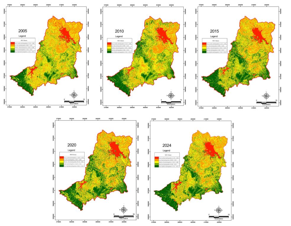
This study enhances the detection of vegetation changes in Thailand’s Phung River Basin, Sakon Nakhon province, by applying the Normalized Difference Vegetation Index (NDVI) within a GIS and remote sensing framework from 2005 to 2024. NDVI, a globally recognized indicator of vegetation health and ecological conditions, was calculated using multi-temporal Landsat imagery. The analysis classified vegetation into five density categories across five time points—2005, 2010, 2015, 2020, and 2024—revealing significant ecological shifts. Dense vegetation increased notably from 11.39% to 20.58%, while areas with moderate and sparse vegetation declined. These changes aligned with demographic trends, including population growth from 2005 to 2020 and a sharp 24% decrease from 2020 to 2024, as well as the implementation of stricter land-use policies. By integrating NDVI-derived analysis, GIS-based spatial modeling, and NDVI change detection, the study substantially improved the monitoring of vegetation dynamics. This approach enabled precise identification of degradation and regeneration zones, offering a practical model for sustainable land management. The methodology presents a scalable tool for other tropical watersheds, supporting regional sustainability strategies across Southeast Asia. The results indicate that vegetation dynamics within the Phung River Basin are closely associated with human-driven activities, notably agricultural expansion and the implementation of land-use regulations. These findings provide essential baseline information to support the development of effective and sustainable forest management policies moving forward.
References
K. Mehmood et al., "Analyzing vegetation health dynamics across seasons and regions through NDVI and climatic variables," Scientific Reports, vol. 14, no. 11775, May 2024.
Visual Capitalist, "Which Countries Have the Largest Forests?" [Online]. Available: https://www.visualcapitalist.com/which-countries-have-the-largest-forests/. (Accessed: December 20, 2024).
Seub Nakhasathien Foundation, "Forest and environmental situation 2023" [Online]. Available: https://www.seub.or.th/forest-environmental-2023/. (Accessed: December 20, 2024).
G. Aziz, N. Minallah, A. Saeed, J. Frnda, and W. Khan, "Remote sensing based forest cover classification using machine learning," Scientific Reports, vol. 14, no. 69, January 2024.
M. Konatowska, A. Młynarczyk, W. Kowalewski, and P. Rutkowski, "NDVI as a potential tool for forecasting changes in geographical range of sycamore (Acer pseudoplatanus L.)," Scientific Reports, vol. 13, no. 19818, November 2023.
C. Suwanprasit and N. Shahnawaz, "Mapping burned areas in Thailand using Sentinel-2 imagery and OBIA techniques," Scientific Reports, vol. 14, no. 9609, April 2024.
W. Han et al., "Assessment of vegetation drought loss and recovery in Central Asia considering a Comprehensive Vegetation Index," Remote Sensing of Environment, vol. 16, no. 22, p. 4189, November 2024.
K. Kulesza and A. Hościło, "Influence of climatic conditions on Normalized Difference Vegetation Index variability in forest in Poland (2002–2021)," Meteorological Applications, vol. 30, no. 5, September 2023.
J. Mašek, J. Tumajer, J. Lange, R. Kaczka, P. Fišer, and V. Treml, "Variability in tree-ring width and NDVI responses to climate at a landscape level," Ecosystems, vol. 26, no. 5, pp. 1144–1157, January 2023.
P. Hajek et al., "Quantifying the influence of tree species richness on community drought resistance using drone-derived NDVI and ground-based measures of Plant Area Index and leaf chlorophyll in a young tree diversity experiment," European Journal of Forest Research, vol. 143, no. 1, pp. 141–155, October 2023.
Thai Meteorological Department, "Thai Meteorological Department: Sakon Nakhon Province Weather" [Online]. Available: https://www.tmd.go.th/weather/province/sakon-nakhon. (Accessed: December 20, 2024).
D. Udoma-Michaels and O. Akinola, "Analysis of Vegetation Index of Protected Forests in Akwa Ibom State, Nigeria between 2000 and 2021," OALib, vol. 09, no. 06, pp. 1–17, January 2022.
E. Rahimi, P. Dong, and C. Jung, "Global NDVI-LST Correlation: Temporal and Spatial Patterns from 2000 to 2024," Environments, vol. 12, no. 2, pp. 67, February 2025.
J. D. Stamford, S. Vialet-Chabrand, I. Cameron, and T. Lawson, "Development of an accurate low cost NDVI imaging system for assessing plant health," Plant Methods, vol. 19, no. 9, January 2023.
S. Erasmi, M. Klinge, C. Dulamsuren, F. Schneider, and M. Hauck, "Modelling the productivity of Siberian larch forests from Landsat NDVI time series in fragmented forest stands of the Mongolian forest-steppe," Environmental Monitoring and Assessment, vol. 193, no. 4, March 2021.
F. Maselli, M. A. Gilabert, and C. Conese, "Integration of high and low resolution NDVI data for monitoring vegetation in Mediterranean environments," Remote Sensing of Environment, vol. 63, no. 3, pp. 208–218, March 1998.
T. T. Wahelo, D. A. Mengistu, and T. M. Merawi, "Spatiotemporal trends and drivers of forest cover change in Metekel Zone forest areas, Northwest Ethiopia," Environmental Monitoring and Assessment, vol. 196, no. 12, November 2024.
E. Vera et al., "Change of vegetation cover and land use of the Pómac forest historical sanctuary in northern Peru," International Journal of Environmental Science and Technology, vol. 21, no. 14, pp. 8919–8930, April 2024.
J. Doornbos, Ö. Babur, and J. Valente, "Evaluating Generalization of Methods for Artificially Generating NDVI from UAV RGB Imagery in Vineyards," Remote Sensing, vol. 17, no. 3, p. 512, February 2025.
L. F. Lopes, F. S. Dias, P. M. Fernandes, and V. Acácio, "A remote sensing assessment of oak forest recovery after postfire restoration," European Journal of Forest Research, vol. 143, no. 3, pp. 1001–1014, March 2024.
A. M. Khutuev, A. Kh. Zanilov, D. A. Tutukova, and I. Yu. Savin, "NDVI of crops as a remote indicator of arable soils quality," Dokuchaev Soil Bulletin, no. 121, pp. 70–85, December 2024.
R. Prăvălie et al., "NDVI-based ecological dynamics of forest vegetation and its relationship to climate change in Romania during 1987–2018," Ecological Indicators, vol. 136, p. 108629, February 2022.
M. T. Bhatti, H. Gilani, M. Ashraf, M. S. Iqbal, and S. Munir, "Field validation of NDVI to identify crop phenological signatures," Precision Agriculture, vol. 25, no. 5, pp. 2245–2270, July 2024.
S. Xu, D. Wang, S. Liang, Y. Liu, and A. Jia, "Assessment of gridded datasets of various near surface temperature variables over Heihe River Basin: Uncertainties, spatial heterogeneity and clear-sky bias," International Journal of Applied Earth Observation and Geoinformation, vol. 120, p. 103347, May 2023.
S. Ehsan and D. Kazem, "Analysis of land use-land covers changes using normalized difference vegetation index (NDVI) differencing and classification methods," African Journal of Agricultural Research, vol. 8, no. 37, pp. 4614–4622, September 2013.
B. Mishra and T. B. Shahi, "Deep learning-based framework for spatiotemporal data fusion: an instance of Landsat 8 and Sentinel 2 NDVI," Journal of Applied Remote Sensing, vol. 15, no. 03, September 2021.
S. Desai, M. Mattoo, A. M. Deshpande, A. Dey, and S. Akiwate, "Vegetation change detection through NDVI analysis using Landsat-8 data," in Proceedings of the IEEE International Conference on Computing, Communication, and Information Technology (C3IT), Adisaptagram, Kolkata, India, March 9–10, 2024, pp. 1–6.
S. Eskandari and S. K. Bordbar, "Provision of land use and forest density maps in semi-arid areas of Iran using Sentinel-2 satellite images and vegetation indices," Advances in Space Research, vol. 75, no. 3, February 2025.
F. Ghilardi, S. De Petris, V. Torti, C. Giacoma, and E. Borgogno-Mondino, "A possible role of NDVI time series from Landsat Mission to characterize lemurs habitats degradation in Madagascar," The Science of the Total Environment, vol. 974, p. 179243, March 2025.
R. G. Congalton and K. Green, Assessing the Accuracy of Remotely Sensed Data, 3rd ed. Boca Raton, FL, USA: CRC Press, 2019.
Z. Zhu and C. E. Woodcock, "Object-based cloud and cloud shadow detection in Landsat imagery," Remote Sensing of Environment, vol. 118, pp. 83–94, December 2011.
S. Foga et al., "Cloud detection algorithm comparison and validation for operational Landsat data products," Remote Sensing of Environment, vol. 194, pp. 379–390, April 2017.
Z. Zhu, S. Wang, and C. E. Woodcock, "Improvement and expansion of the Fmask algorithm: cloud, cloud shadow, and snow detection for Landsats 4–7, 8, and Sentinel 2 images," Remote Sensing of Environment, vol. 159, pp. 269–277, January 2015.
U.S. Geological Survey, "Landsat Surface Reflectance" [Online]. Available: https://www.usgs.gov/landsat-missions/landsat-surface-reflectance. (Accessed: October 23, 2024).
N. Gorelick, M. Hancher, M. Dixon, S. Ilyushchenko, D. Thau, and R. Moore, "Google Earth Engine: Planetary-scale geospatial analysis for everyone," Remote Sensing of Environment, vol. 202, pp. 18–27, July 2017.
Forest Research and Development Office, "Forestry in Thailand" [Online]. Available: https://forprod.forest.go.th/forprod/ebook/การป่าไม้ในประเทศไทย/Forest%20in%20thailand%20eng.pdf. (Accessed: April 14, 2025).
NASA, "Landsat Satellites" [Online]. Available: https://landsat.gsfc.nasa.gov/satellites/. (Accessed: May 14, 2025).
Downloads
Published
How to Cite
Issue
Section
Categories
License
Copyright (c) 2025 NKRAFA JOURNAL OF SCIENCE AND TECHNOLOGY

This work is licensed under a Creative Commons Attribution-NonCommercial-NoDerivatives 4.0 International License.
- Content and information in articles published in NKRAFA Journal of Science and Technology are comment and responsibility of authors of articles directly. Journal editorial do no need to agree or share any responsibility.
- NKRAFA Journal of Science and Technology Articles holds the copyright of the content, pictures, images etc. which published in it. If any person or agency require to reuse all or some part of articles, the permission must be obtained from the NKRAFA Journal of Science and Technology.