
Bathymetric Resolution Analysis of the Gulf of Thailand
Article Sidebar
Main Article Content
Abstract
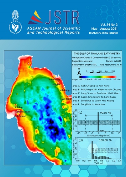
The GEBCO30 bathymetric data resolution 0.5 nautical miles in the Gulf of Thailand were corrected by comparison with the digitized Navigation Charts data from 47 charts in total that were surveyed and published between 1991 and 2005. The correction of bathymetric data and modification of map resolution from 926 meters to 200 and 50 meters were done by using scripts of the Generic Mapping Tools (GMT) programming. The result showed that the corrected GEBCO30 data in the Gulf of Thailand resolution 50 meters had 27,704,202 data and depth ranges (-97.99) – (2.51) meters. 99.07% of the data showed the discrepant depths with total horizontal uncertainty within 95% confidence level of ±10 meters. All of the data showed the discrepant depths with total vertical uncertainty within 95% confidence level of ±1.3685 meters and the value of Standard Deviation (SD) of 0.1945 that was better than the resolution 926 and 200 meters, respectively. The corrected GEBCO30 bathymetric data and adjusted resolution to 50 meters had the confidence following the standard of the International Hydrographic Organization, and all data also showed SD less than 1% of water depth.
Article Details

This work is licensed under a Creative Commons Attribution-NonCommercial-NoDerivatives 4.0 International License.
References
Buranapratheprat, A., & Bunpapong, M. (1998). A two-dimension hydrodynamic model for the Gulf of Thailand. In The IOC/WESTPAC Fourth International Scientific Symposium, 469–478. February 2-7, 1998, Okinawa: Japan.
Yanagi, T., Sachoemar, S.I., Takao, T., & Fujiwara, S. (2001). Seasonal variation of stratification in the Gulf of Thailand. Journal of Oceanography, 57, 461–470.
Jintasaeranee, P. (1998). Circulation of deep water masses in the Gulf of Thailand using natural Radium-226 and Radium-228 radiotracers. Graduate Thesis. Chulalongkorn University. (in Thai)
Phaksopa, J., & Sojisuporn, P. (2006). Storm surge in the Gulf of Thailand generated by Typhoon Linda in 1997 using Princeton Ocean Model (POM). Kasetsart Journal (Natural Science), 40, 260–268.
Cheevaporn, V., & Menasveta, P. (2003). Water pollution and habitat degradation in the Gulf of Thailand. Marine Pollution Bulletin, 47, 43–51.
Wattayakorn, G. (2012). Petroleum pollution in the Gulf of Thailand: A historical review. Coastal Marine Science, 35(1), 234–245.
General Bathymetric Chart of the Oceans (2010). The GEBCO_08 Grid. version 20100927 (On line). Retrieved 25 October 2010 from https://www.gebco.net/data_and_products/gridded_bathymetry_data/documents/gebco_08.pdf.
Marks, K.M., & Smith, W.H.F. (2005). 2,500 m isobath from satellite bathymetry: Accuracy assessment in light of IHO S-44 standards. International Hydrographic Review, 6(2), 1–11.
Sandwell, D.T., Smith, W.H.F., Gille, S., Kappel, E., Jayne, S., Soofi, K., Coakley, B., & Geli, L. (2006). Bathymetry from space: Rationale and requirements for a new, high-resolution altimetric mission. C.R. Geoscience, 338, 1049–1062.
Jintasaeranee, P. (2012). Accuracy of the general bathymetry (GEBCO 30 arc-second) in the Upper Gulf of Thailand. Burapha Science Journal, 17(1), 69–76. (in Thai).
International Hydrographic Bureau (2008). IHO standards for hydrographic surveys, 5th Edition, February 2008. Monaco: International Hydrographic Bureau.
Beyer, A., Schenke, H.W., Klenke, M., & Niederjasper, F. (2003). High resolution bathymetry of the eastern slope of the Porcupine Seabight. Marine Geology, 198, 27–54.
Beyer, A., Rathlau, R., & Schenke, H.W. (2005). Multibeam bathymetry of the Hakon Mosby mud volcano. Marine Geophysical Researches, 26, 61–75.
Jintasaeranee, P. (2018). A high resolution bathymetric data for the inner Gulf of Thailand. Burapha Science Journal, 23(3), 1559–1570. (in Thai)
Jintasaeranee, P., & Buranapratheprat, A. (2017). A correction of the general bathymetric data in the Gulf of Thailand. Burapha Science Journal, 22(2), 118–134. (in Thai)
Smith, W.H.F., & Sandwell, D.T. (2004). Conventional bathymetry, bathymetry from space, and geodetic altimetry. Oceanography, 17(1), 8–23.
Wessel, P., & Smith, W.H.F. (1998). New improved version of generic mapping tools release. EOS Transactions American Geophysical Union, 79(47), 579.
